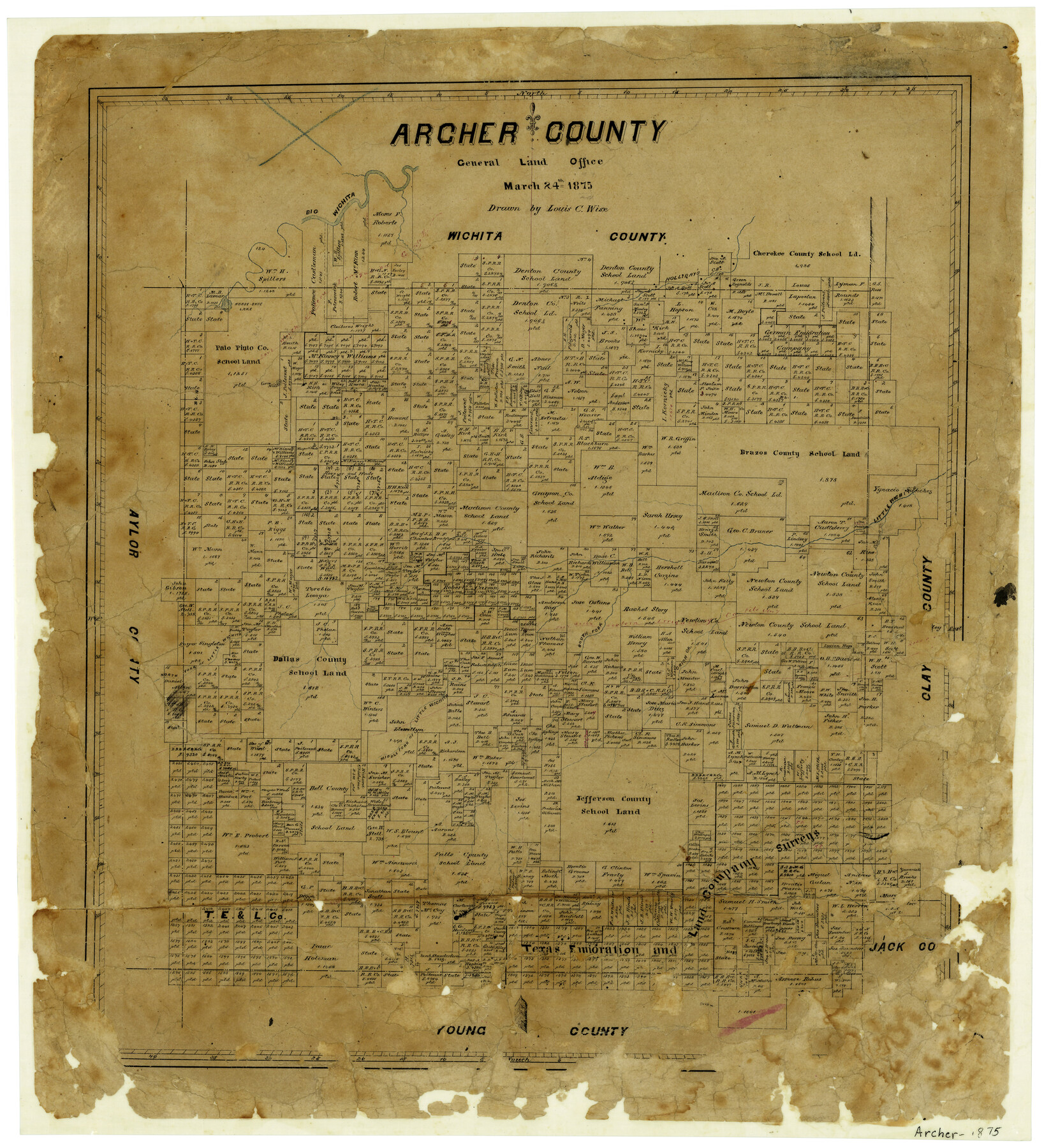
Archer County
-
Map/Doc
3238
-
Collection
General Map Collection
-
Object Dates
3/24/1875 (Creation Date)
-
People and Organizations
Texas General Land Office (Publisher)
Louis C. Wise (Draftsman)
-
Counties
Archer
-
Subjects
County
-
Height x Width
24.2 x 21.7 inches
61.5 x 55.1 cm
-
Features
Holliday's Creek
Big Wichita
Horse-shoe [sic] Lake
Little Wichita River
North Fork of Little Wichita River
South fork of Little Wichita River
Onion Creek
Middle Fork of Little Wichita River
Bob's Creek
Corn Hill
Post Oak Creek
Part of: General Map Collection
Brazoria County NRC Article 33.136 Sketch 24

Print $24.00
Brazoria County NRC Article 33.136 Sketch 24
2025
Map/Doc 97504
Flight Mission No. CRC-3R, Frame 48, Chambers County

Print $20.00
- Digital $50.00
Flight Mission No. CRC-3R, Frame 48, Chambers County
1956
Size 18.7 x 22.4 inches
Map/Doc 84821
Flight Mission No. BRA-17M, Frame 12, Jefferson County

Print $20.00
- Digital $50.00
Flight Mission No. BRA-17M, Frame 12, Jefferson County
1953
Size 18.5 x 22.3 inches
Map/Doc 85793
Baylor County

Print $20.00
- Digital $50.00
Baylor County
1961
Size 40.6 x 33.0 inches
Map/Doc 77209
La Salle County Rolled Sketch 14B

Print $20.00
- Digital $50.00
La Salle County Rolled Sketch 14B
Size 20.7 x 23.0 inches
Map/Doc 6578
Gaines County Working Sketch 8

Print $20.00
- Digital $50.00
Gaines County Working Sketch 8
1951
Size 21.8 x 24.8 inches
Map/Doc 69308
San Saba County Working Sketch 6

Print $20.00
- Digital $50.00
San Saba County Working Sketch 6
1959
Size 17.5 x 23.4 inches
Map/Doc 63794
Flight Mission No. CLL-1N, Frame 198, Willacy County

Print $20.00
- Digital $50.00
Flight Mission No. CLL-1N, Frame 198, Willacy County
1954
Size 18.4 x 22.1 inches
Map/Doc 87068
Polk County Sketch File 3

Print $10.00
- Digital $50.00
Polk County Sketch File 3
1848
Size 8.5 x 7.6 inches
Map/Doc 34122
Harris County Rolled Sketch 86

Print $40.00
- Digital $50.00
Harris County Rolled Sketch 86
Size 50.4 x 43.9 inches
Map/Doc 73581
Edwards County Rolled Sketch 16A

Print $20.00
- Digital $50.00
Edwards County Rolled Sketch 16A
1944
Size 25.0 x 19.0 inches
Map/Doc 5805
Aransas County Rolled Sketch 27E

Print $20.00
- Digital $50.00
Aransas County Rolled Sketch 27E
1958
Size 30.2 x 30.9 inches
Map/Doc 8419
You may also like
Flight Mission No. DAG-26K, Frame 63, Matagorda County

Print $20.00
- Digital $50.00
Flight Mission No. DAG-26K, Frame 63, Matagorda County
1953
Size 18.5 x 22.2 inches
Map/Doc 86583
Map of the International and Great Northern Railroad between Austin and San Antonio, Texas

Print $40.00
- Digital $50.00
Map of the International and Great Northern Railroad between Austin and San Antonio, Texas
1881
Size 43.2 x 96.0 inches
Map/Doc 64777
Wise County Sketch File 16 and 17

Print $4.00
- Digital $50.00
Wise County Sketch File 16 and 17
1856
Size 13.1 x 8.3 inches
Map/Doc 40551
Dickens County Sketch File 19a

Print $23.00
- Digital $50.00
Dickens County Sketch File 19a
Size 9.6 x 7.8 inches
Map/Doc 21031

Fisher County Sketch File A2

Print $20.00
- Digital $50.00
Fisher County Sketch File A2
1901
Size 35.8 x 31.0 inches
Map/Doc 10450
Central Plains 'Holiness' College Grounds

Print $20.00
- Digital $50.00
Central Plains 'Holiness' College Grounds
1906
Size 17.2 x 30.8 inches
Map/Doc 92124
[I. Killough and Hiram Cates surveys and vicinity]
![91851, [I. Killough and Hiram Cates surveys and vicinity], Twichell Survey Records](https://historictexasmaps.com/wmedia_w700/maps/91851-1.tif.jpg)
Print $20.00
- Digital $50.00
[I. Killough and Hiram Cates surveys and vicinity]
Size 27.5 x 9.2 inches
Map/Doc 91851

Presidio County Sketch File 88

Print $6.00
- Digital $50.00
Presidio County Sketch File 88
Size 14.5 x 8.8 inches
Map/Doc 34751
[Blk. B, Secs. 111-114 and vicinity]
![90340, [Blk. B, Secs. 111-114 and vicinity], Twichell Survey Records](https://historictexasmaps.com/wmedia_w700/maps/90340-1.tif.jpg)
Print $20.00
- Digital $50.00
[Blk. B, Secs. 111-114 and vicinity]
Size 31.3 x 38.7 inches
Map/Doc 90340
Yates Pool, Pecos County, Texas

Print $20.00
- Digital $50.00
Yates Pool, Pecos County, Texas
1920
Size 17.5 x 15.7 inches
Map/Doc 91564