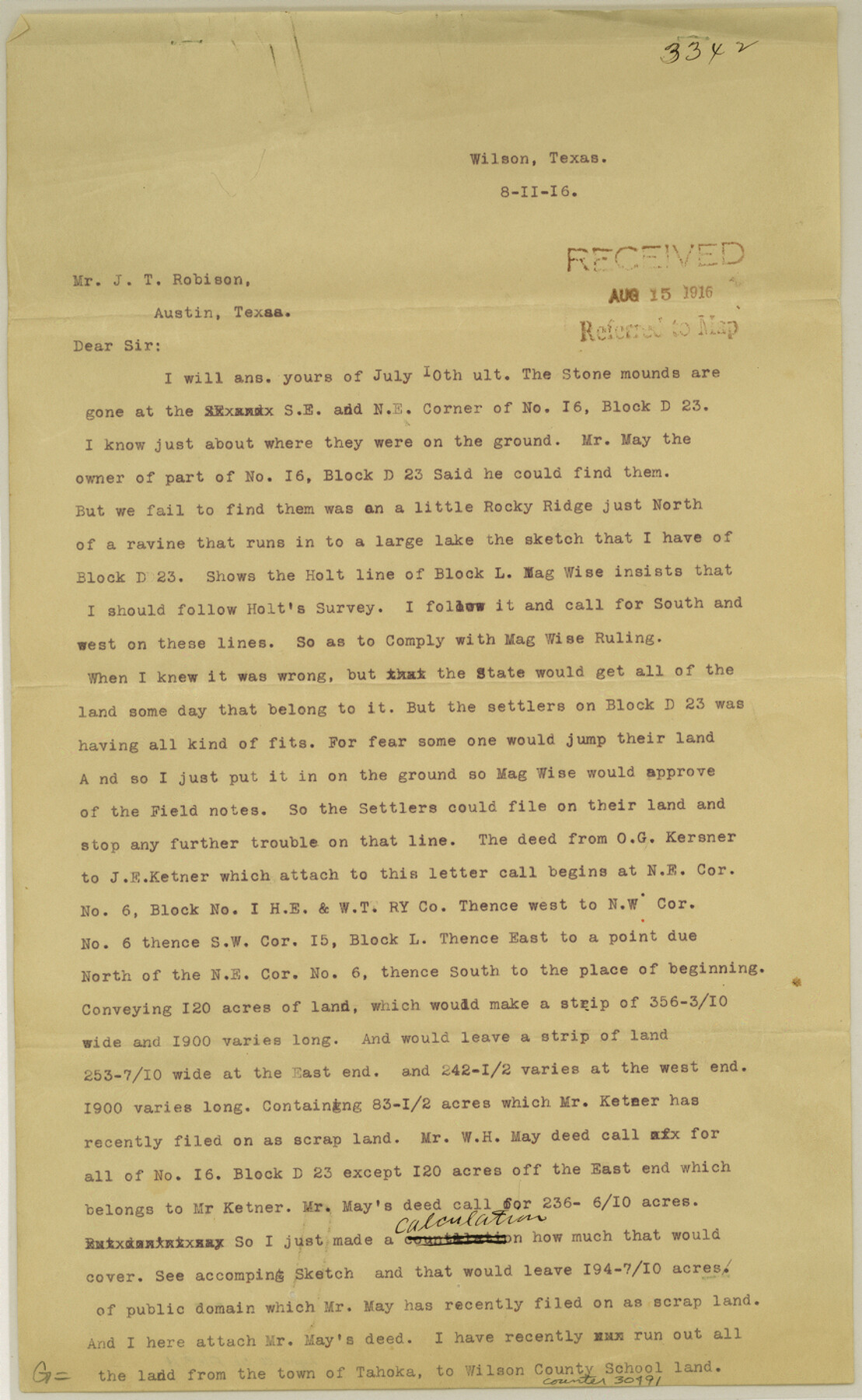
Lynn County Sketch File 14
[Letter from W. R. Standefer to J. T. Robison]
-
Map/Doc
30491
-
Collection
General Map Collection
-
Object Dates
8/11/1916 (Creation Date)
8/15/1916 (File Date)
8/11/1916 (Correspondence Date)
1/1878 (Survey Date)
5/1878 (Survey Date)
-
People and Organizations
W.R. Standefer (Surveyor/Engineer)
J.H. Ramsey (Surveyor/Engineer)
W.D. Twichell (Surveyor/Engineer)
-
Counties
Lynn Borden
-
Subjects
Surveying Sketch File
-
Height x Width
14.1 x 8.7 inches
35.8 x 22.1 cm
-
Medium
paper, print
-
Features
Tahoka
Double Lakes
Graham
Midia Kong Peak
Part of: General Map Collection
Zavala County Rolled Sketch 14

Print $20.00
- Digital $50.00
Zavala County Rolled Sketch 14
1887
Size 28.1 x 40.8 inches
Map/Doc 10175
Concho County Boundary File 3

Print $10.00
- Digital $50.00
Concho County Boundary File 3
Size 8.5 x 3.9 inches
Map/Doc 51820
[Map of Terrell County]
![4074, [Map of Terrell County], General Map Collection](https://historictexasmaps.com/wmedia_w700/maps/4074.tif.jpg)
Print $20.00
- Digital $50.00
[Map of Terrell County]
Size 38.0 x 24.0 inches
Map/Doc 4074
Map of the State of Texas Showing Original Land Districts

Print $20.00
- Digital $50.00
Map of the State of Texas Showing Original Land Districts
1891
Size 42.2 x 42.4 inches
Map/Doc 2138
Floyd County Boundary File 1

Print $30.00
- Digital $50.00
Floyd County Boundary File 1
Size 8.9 x 4.2 inches
Map/Doc 53445
Harris County Boundary File 39 (20)

Print $4.00
- Digital $50.00
Harris County Boundary File 39 (20)
Size 10.1 x 8.0 inches
Map/Doc 54363
[Sketch showing the Rio Grande with towns and features annotated]
![72896, [Sketch showing the Rio Grande with towns and features annotated], General Map Collection](https://historictexasmaps.com/wmedia_w700/maps/72896.tif.jpg)
Print $20.00
- Digital $50.00
[Sketch showing the Rio Grande with towns and features annotated]
1854
Size 24.1 x 18.2 inches
Map/Doc 72896
Upton County Rolled Sketch 16

Print $20.00
- Digital $50.00
Upton County Rolled Sketch 16
1927
Size 18.9 x 37.7 inches
Map/Doc 8071
A Topographical Map of the Government Tract adjoining the City of Austin

Print $20.00
- Digital $50.00
A Topographical Map of the Government Tract adjoining the City of Austin
1840
Size 41.9 x 37.8 inches
Map/Doc 2180

Marion County Sketch File 7

Print $40.00
- Digital $50.00
Marion County Sketch File 7
1866
Size 16.2 x 12.0 inches
Map/Doc 30573
Montgomery County Sketch File 25

Print $4.00
- Digital $50.00
Montgomery County Sketch File 25
1839
Size 13.8 x 8.2 inches
Map/Doc 31869
You may also like
[H. E. & W. T. Block 9, L. S. & V. Block 1, Public School Land Block C-40, Portion of Block H]
![91354, [H. E. & W. T. Block 9, L. S. & V. Block 1, Public School Land Block C-40, Portion of Block H], Twichell Survey Records](https://historictexasmaps.com/wmedia_w700/maps/91354-1.tif.jpg)
Print $20.00
- Digital $50.00
[H. E. & W. T. Block 9, L. S. & V. Block 1, Public School Land Block C-40, Portion of Block H]
Size 27.0 x 33.3 inches
Map/Doc 91354
Plan of the town of Austin

Print $20.00
- Digital $50.00
Plan of the town of Austin
Size 18.4 x 13.0 inches
Map/Doc 94117

San Augustine County Working Sketch 12

Print $20.00
- Digital $50.00
San Augustine County Working Sketch 12
1951
Size 29.0 x 21.0 inches
Map/Doc 63700
Calhoun County Aerial Photograph Index Sheet 1

Print $20.00
- Digital $50.00
Calhoun County Aerial Photograph Index Sheet 1
1953
Size 23.7 x 19.7 inches
Map/Doc 83670

Brazoria County Sketch File 49

Print $20.00
- Digital $50.00
Brazoria County Sketch File 49
Size 14.2 x 8.7 inches
Map/Doc 15112
Sabine Pass and Lake

Print $20.00
- Digital $50.00
Sabine Pass and Lake
1945
Size 46.5 x 27.3 inches
Map/Doc 69822
Polk County Sketch File 24

Print $20.00
- Digital $50.00
Polk County Sketch File 24
Size 14.3 x 30.8 inches
Map/Doc 12193
Maverick County Sketch File 19

Print $4.00
- Digital $50.00
Maverick County Sketch File 19
1887
Size 12.8 x 9.0 inches
Map/Doc 31128
Cottle County Sketch File 2

Print $20.00
- Digital $50.00
Cottle County Sketch File 2
1882
Size 32.9 x 19.6 inches
Map/Doc 76757
Flight Mission No. BRE-1P, Frame 25, Nueces County

Print $20.00
- Digital $50.00
Flight Mission No. BRE-1P, Frame 25, Nueces County
1956
Size 18.6 x 22.4 inches
Map/Doc 86620