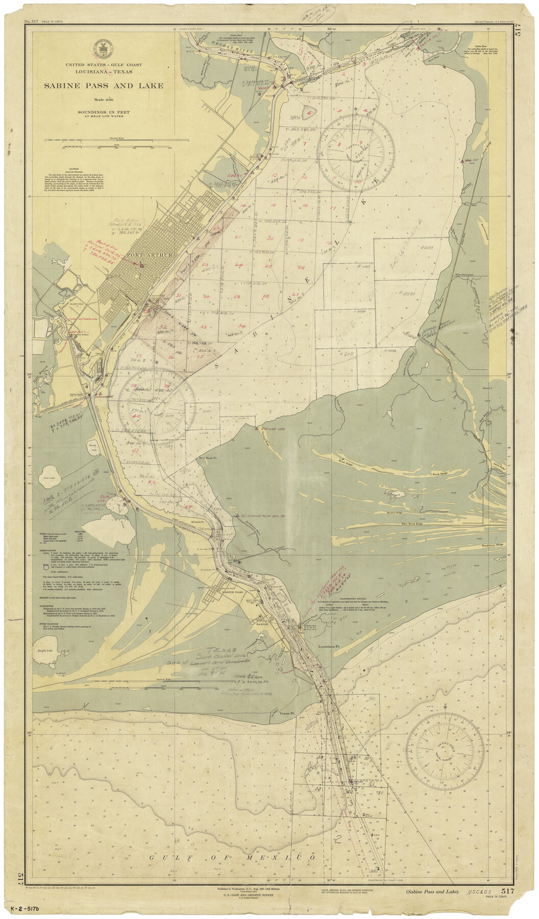
Sabine Pass and Lake
K-2-517a
-
Map/Doc
69822
-
Collection
General Map Collection
-
Object Dates
11/17/1945 (Creation Date)
-
Counties
Orange Jefferson
-
Subjects
Nautical Charts
-
Height x Width
46.5 x 27.3 inches
118.1 x 69.3 cm
Part of: General Map Collection
Edwards County Working Sketch 80

Print $20.00
- Digital $50.00
Edwards County Working Sketch 80
1963
Size 23.4 x 23.2 inches
Map/Doc 68956
Outer Continental Shelf Leasing Maps (Texas Offshore Operations)

Print $20.00
- Digital $50.00
Outer Continental Shelf Leasing Maps (Texas Offshore Operations)
Size 21.0 x 15.2 inches
Map/Doc 75840
Flight Mission No. DAG-23K, Frame 172, Matagorda County

Print $20.00
- Digital $50.00
Flight Mission No. DAG-23K, Frame 172, Matagorda County
1953
Size 18.6 x 16.0 inches
Map/Doc 86510

Garza County Sketch File J

Print $20.00
- Digital $50.00
Garza County Sketch File J
1911
Size 26.5 x 7.5 inches
Map/Doc 11555
Zavala County Sketch File 49

Print $10.00
- Digital $50.00
Zavala County Sketch File 49
1955
Size 14.5 x 9.1 inches
Map/Doc 41441
Hudspeth County Rolled Sketch 59

Print $40.00
- Digital $50.00
Hudspeth County Rolled Sketch 59
Size 69.2 x 42.8 inches
Map/Doc 9224
Wharton County Working Sketch 23

Print $20.00
- Digital $50.00
Wharton County Working Sketch 23
1919
Size 22.0 x 36.0 inches
Map/Doc 72487
Stonewall County Working Sketch 2

Print $20.00
- Digital $50.00
Stonewall County Working Sketch 2
1915
Size 22.7 x 15.2 inches
Map/Doc 63996
[Map of Terrell County]
![4074, [Map of Terrell County], General Map Collection](https://historictexasmaps.com/wmedia_w700/maps/4074.tif.jpg)
Print $20.00
- Digital $50.00
[Map of Terrell County]
Size 38.0 x 24.0 inches
Map/Doc 4074
Coke County Boundary File 4

Print $44.00
- Digital $50.00
Coke County Boundary File 4
Size 14.3 x 8.7 inches
Map/Doc 51593
Galveston County NRC Article 33.136 Location Key Sheet

Print $20.00
- Digital $50.00
Galveston County NRC Article 33.136 Location Key Sheet
1994
Size 27.0 x 21.8 inches
Map/Doc 77019
You may also like
Nautical Chart 518-SC: Galveston Bay Entrance

Print $20.00
- Digital $50.00
Nautical Chart 518-SC: Galveston Bay Entrance
1971
Size 19.2 x 19.1 inches
Map/Doc 75909
Presidio County Working Sketch 112

Print $20.00
- Digital $50.00
Presidio County Working Sketch 112
1979
Size 41.7 x 35.6 inches
Map/Doc 71789
Ochiltree County Working Sketch 6

Print $20.00
- Digital $50.00
Ochiltree County Working Sketch 6
1962
Size 31.1 x 22.9 inches
Map/Doc 71319
Nueces County Sketch File 48

Print $20.00
- Digital $50.00
Nueces County Sketch File 48
1978
Size 14.1 x 8.5 inches
Map/Doc 32663
[Surveys in Vehlein's Colony along Long King's Creek]
![83, [Surveys in Vehlein's Colony along Long King's Creek], General Map Collection](https://historictexasmaps.com/wmedia_w700/maps/83.tif.jpg)
Print $20.00
- Digital $50.00
[Surveys in Vehlein's Colony along Long King's Creek]
Size 13.3 x 19.0 inches
Map/Doc 83
Flight Mission No. DCL-7C, Frame 148, Kenedy County

Print $20.00
- Digital $50.00
Flight Mission No. DCL-7C, Frame 148, Kenedy County
1943
Size 17.3 x 22.5 inches
Map/Doc 86105
Real County Working Sketch 62

Print $20.00
- Digital $50.00
Real County Working Sketch 62
1966
Size 26.4 x 23.2 inches
Map/Doc 71954
Zavala County Sketch File 36

Print $6.00
- Digital $50.00
Zavala County Sketch File 36
1889
Size 10.9 x 8.2 inches
Map/Doc 41399
Right of Way and Track Map - Houston & Texas Central R.R. operated by the T. and N. O. R.R. Co. - Main Line

Print $40.00
- Digital $50.00
Right of Way and Track Map - Houston & Texas Central R.R. operated by the T. and N. O. R.R. Co. - Main Line
1918
Size 25.2 x 57.8 inches
Map/Doc 82859
Crockett County Working Sketch 1

Print $20.00
- Digital $50.00
Crockett County Working Sketch 1
Size 20.7 x 16.7 inches
Map/Doc 68334
Mills County Boundary File Index

Print $2.00
- Digital $50.00
Mills County Boundary File Index
Size 8.8 x 8.9 inches
Map/Doc 57258
Bird's Eye View of the City of Galveston Texas

Print $20.00
Bird's Eye View of the City of Galveston Texas
1871
Size 20.4 x 30.8 inches
Map/Doc 89086