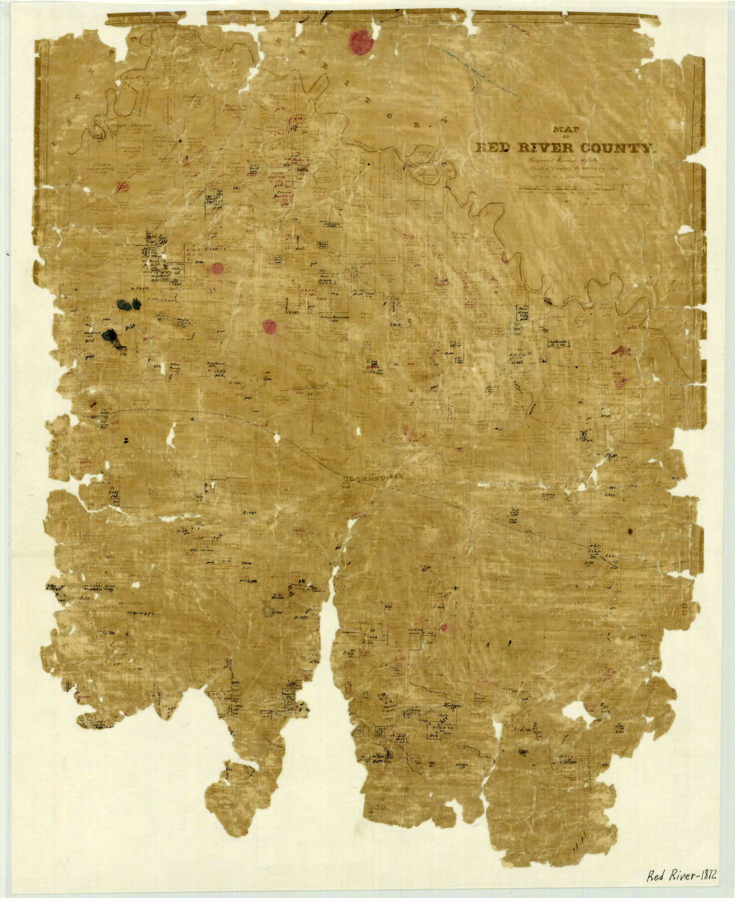
Map of Red River County
-
Map/Doc
3979
-
Collection
General Map Collection
-
Object Dates
1872 (Creation Date)
-
People and Organizations
Texas General Land Office (Publisher)
Herman Lungkwitz (Draftsman)
Louis Klappenbach (Draftsman)
-
Counties
Red River
-
Subjects
County
-
Height x Width
21.6 x 17.7 inches
54.9 x 45.0 cm
-
Features
South Fork of Pecan Bayou
Mill Creek
Cany Creek
Burris Bayou
Slapham Creek
Daton Road
Kickapoo Creek
Bruton Creek
Clarksville
Hamilton's Bayou
Little Creek
Shaw's Ferry
White Oak Fork of Pecan Bayou
Slingland
Haslett's Lake
Pine Creek
Red River
Atkinson's Lake
Part of: General Map Collection
Jefferson County Sketch File 51

Print $10.00
- Digital $50.00
Jefferson County Sketch File 51
Size 10.0 x 6.7 inches
Map/Doc 28249
Houston County Working Sketch 24

Print $40.00
- Digital $50.00
Houston County Working Sketch 24
1983
Size 43.9 x 77.2 inches
Map/Doc 66254
Brewster County Working Sketch 105

Print $40.00
- Digital $50.00
Brewster County Working Sketch 105
1980
Size 42.5 x 77.6 inches
Map/Doc 67705
Panola County Working Sketch 27

Print $20.00
- Digital $50.00
Panola County Working Sketch 27
1956
Map/Doc 71436
Glasscock County Sketch File 25

Print $20.00
- Digital $50.00
Glasscock County Sketch File 25
1951
Size 28.8 x 20.6 inches
Map/Doc 11566
Austin County Sketch File 8

Print $40.00
- Digital $50.00
Austin County Sketch File 8
1894
Size 19.3 x 19.9 inches
Map/Doc 10873
Nueces County Working Sketch 11

Print $20.00
- Digital $50.00
Nueces County Working Sketch 11
1965
Size 20.2 x 44.1 inches
Map/Doc 71313
Newton County Rolled Sketch 21

Print $40.00
- Digital $50.00
Newton County Rolled Sketch 21
1957
Size 29.9 x 52.5 inches
Map/Doc 9582
Tom Green County Sketch File 14

Print $20.00
- Digital $50.00
Tom Green County Sketch File 14
Size 34.8 x 45.7 inches
Map/Doc 10401
Pecos County Working Sketch 67
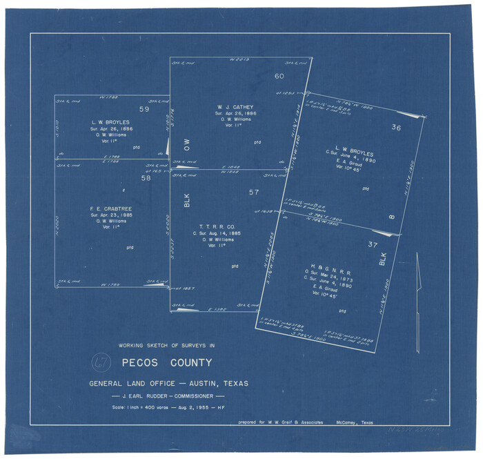
Print $20.00
- Digital $50.00
Pecos County Working Sketch 67
1955
Size 17.7 x 18.7 inches
Map/Doc 71539
Map of Lamar County

Print $20.00
- Digital $50.00
Map of Lamar County
1849
Size 25.7 x 26.8 inches
Map/Doc 1236
Kaufman County

Print $20.00
- Digital $50.00
Kaufman County
1896
Size 44.0 x 28.0 inches
Map/Doc 3751
You may also like
Brewster County Sketch File 43

Print $4.00
- Digital $50.00
Brewster County Sketch File 43
Size 8.8 x 11.3 inches
Map/Doc 16309
Floyd County Working Sketch 1

Print $20.00
- Digital $50.00
Floyd County Working Sketch 1
1949
Size 24.5 x 24.1 inches
Map/Doc 69180
Lampasas County Sketch File 9

Print $4.00
- Digital $50.00
Lampasas County Sketch File 9
1873
Size 9.4 x 7.3 inches
Map/Doc 29408
Corpus Christi Pass

Print $20.00
- Digital $50.00
Corpus Christi Pass
Size 45.7 x 41.2 inches
Map/Doc 78454
Calhoun County Sketch File 4

Print $14.00
- Digital $50.00
Calhoun County Sketch File 4
1908
Size 11.0 x 6.9 inches
Map/Doc 35901
Flight Mission No. BRA-16M, Frame 120, Jefferson County

Print $20.00
- Digital $50.00
Flight Mission No. BRA-16M, Frame 120, Jefferson County
1953
Size 18.4 x 22.6 inches
Map/Doc 85730
Map of Brett Ranch situated in McMullen & La Salle Counties

Print $20.00
- Digital $50.00
Map of Brett Ranch situated in McMullen & La Salle Counties
Size 20.0 x 22.3 inches
Map/Doc 5068
Flight Mission No. DAG-21K, Frame 87, Matagorda County

Print $20.00
- Digital $50.00
Flight Mission No. DAG-21K, Frame 87, Matagorda County
1952
Size 18.5 x 22.4 inches
Map/Doc 86416
Chambers County Sketch File 18b

Print $15.00
- Digital $50.00
Chambers County Sketch File 18b
1901
Size 9.2 x 8.1 inches
Map/Doc 17571
Guadalupe County Sketch File 11

Print $4.00
- Digital $50.00
Guadalupe County Sketch File 11
Size 8.0 x 12.8 inches
Map/Doc 24681
Tyler County Sketch File 28

Print $46.00
- Digital $50.00
Tyler County Sketch File 28
1960
Size 9.8 x 8.6 inches
Map/Doc 38699
Goliad County Working Sketch 4

Print $20.00
- Digital $50.00
Goliad County Working Sketch 4
1920
Size 30.5 x 30.0 inches
Map/Doc 63194