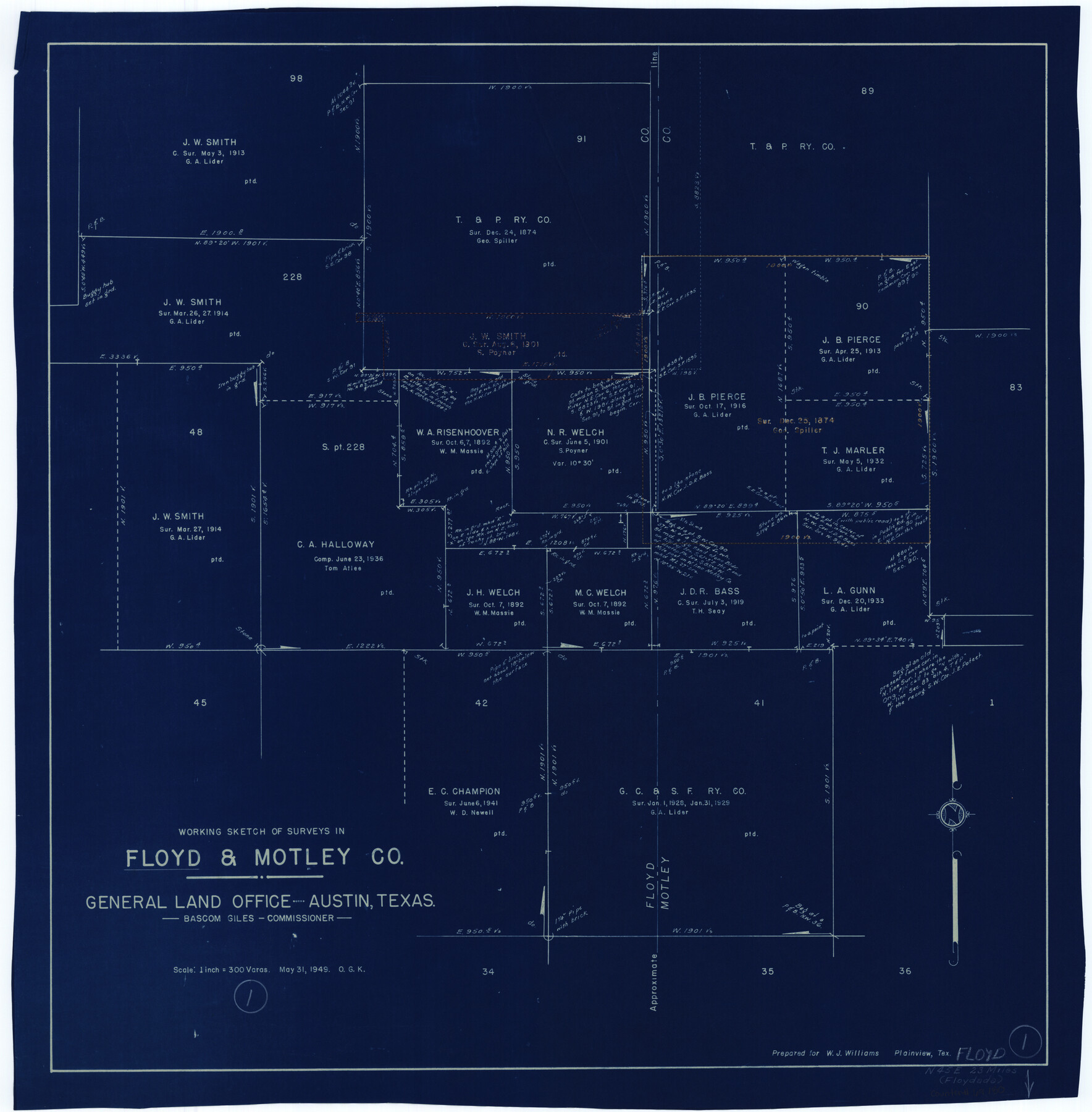
Floyd County Working Sketch 1
-
Map/Doc
69180
-
Collection
General Map Collection
-
Object Dates
5/31/1949 (Creation Date)
-
People and Organizations
Otto G. Kurio (Draftsman)
-
Counties
Floyd Motley
-
Subjects
Surveying Working Sketch
-
Height x Width
24.5 x 24.1 inches
62.2 x 61.2 cm
-
Scale
1" = 300 varas
Part of: General Map Collection
Bosque County Working Sketch 19

Print $20.00
- Digital $50.00
Bosque County Working Sketch 19
1976
Size 28.7 x 27.7 inches
Map/Doc 67452

Gregg County Boundary File 3

Print $8.00
- Digital $50.00
Gregg County Boundary File 3
Size 14.1 x 8.5 inches
Map/Doc 53988

Crockett County Sketch File 57

Print $22.00
- Digital $50.00
Crockett County Sketch File 57
Size 12.2 x 8.9 inches
Map/Doc 19832
Flight Mission No. CUG-1P, Frame 26, Kleberg County

Print $20.00
- Digital $50.00
Flight Mission No. CUG-1P, Frame 26, Kleberg County
1956
Size 18.6 x 22.2 inches
Map/Doc 86116
Flight Mission No. BQR-9K, Frame 46, Brazoria County

Print $20.00
- Digital $50.00
Flight Mission No. BQR-9K, Frame 46, Brazoria County
1952
Size 18.7 x 22.3 inches
Map/Doc 84050
Map of Carson County

Print $20.00
- Digital $50.00
Map of Carson County
1898
Size 40.7 x 37.6 inches
Map/Doc 4904
Current Miscellaneous File 24a

Print $8.00
- Digital $50.00
Current Miscellaneous File 24a
1949
Size 11.0 x 8.6 inches
Map/Doc 73893
Sketch Showing surveys on Harbor Island in Nueces County

Print $20.00
- Digital $50.00
Sketch Showing surveys on Harbor Island in Nueces County
1951
Size 45.7 x 34.6 inches
Map/Doc 1915
Sutton County Rolled Sketch 67

Print $20.00
- Digital $50.00
Sutton County Rolled Sketch 67
Size 25.4 x 37.3 inches
Map/Doc 7902
Atascosa County Working Sketch 16

Print $20.00
- Digital $50.00
Atascosa County Working Sketch 16
1943
Size 16.3 x 20.2 inches
Map/Doc 67212
You may also like
[Spade and Ellwood Lands in Lubbock and Hale Counties]
![91072, [Spade and Ellwood Lands in Lubbock and Hale Counties], Twichell Survey Records](https://historictexasmaps.com/wmedia_w700/maps/91072-1.tif.jpg)
Print $20.00
- Digital $50.00
[Spade and Ellwood Lands in Lubbock and Hale Counties]
Size 18.0 x 17.8 inches
Map/Doc 91072
Working Sketch Archer County

Print $20.00
- Digital $50.00
Working Sketch Archer County
1924
Size 26.6 x 20.5 inches
Map/Doc 90257
Wharton County Sketch File 3

Print $4.00
- Digital $50.00
Wharton County Sketch File 3
1875
Size 9.1 x 8.3 inches
Map/Doc 39915
Austin County Rolled Sketch 6

Print $20.00
- Digital $50.00
Austin County Rolled Sketch 6
1951
Size 25.5 x 34.0 inches
Map/Doc 5108
General Highway Map. Detail of Cities and Towns in Tarrant County, Texas [Fort Worth and vicinity]
![79252, General Highway Map. Detail of Cities and Towns in Tarrant County, Texas [Fort Worth and vicinity], Texas State Library and Archives](https://historictexasmaps.com/wmedia_w700/maps/79252-GC.tif.jpg)
Print $20.00
General Highway Map. Detail of Cities and Towns in Tarrant County, Texas [Fort Worth and vicinity]
1940
Size 24.9 x 18.2 inches
Map/Doc 79252
Sherman County Rolled Sketch 6

Print $20.00
- Digital $50.00
Sherman County Rolled Sketch 6
1919
Size 37.3 x 36.0 inches
Map/Doc 10731
Potter County Boundary File 1b

Print $8.00
- Digital $50.00
Potter County Boundary File 1b
Size 14.4 x 8.4 inches
Map/Doc 57948
McLennan County Working Sketch 2

Print $20.00
- Digital $50.00
McLennan County Working Sketch 2
1941
Size 21.8 x 30.0 inches
Map/Doc 70695
Wheeler County Working Sketch 20

Print $20.00
- Digital $50.00
Wheeler County Working Sketch 20
1989
Size 40.4 x 32.6 inches
Map/Doc 72509
Limestone County Boundary File 59

Print $34.00
- Digital $50.00
Limestone County Boundary File 59
Size 7.4 x 8.7 inches
Map/Doc 56299
Comanche County Working Sketch 2

Print $20.00
- Digital $50.00
Comanche County Working Sketch 2
1918
Size 15.0 x 21.5 inches
Map/Doc 68136
