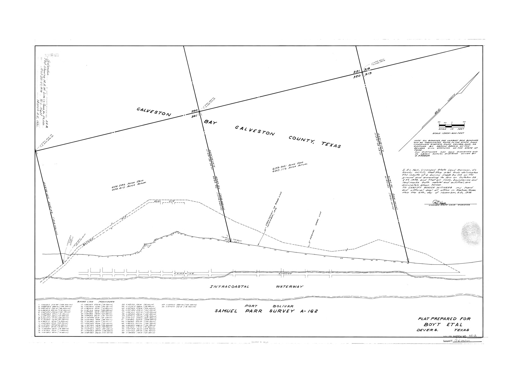
Galveston County Rolled Sketch 34A
[Plat showing M.H.W. line in Cause No. 116,660]
-
Map/Doc
5967
-
Collection
General Map Collection
-
Object Dates
1981/3/25 (File Date)
1978/11/6 (Creation Date)
-
People and Organizations
R.L. Hall (Surveyor/Engineer)
-
Counties
Galveston
-
Subjects
Surveying Rolled Sketch
-
Height x Width
30.2 x 40.9 inches
76.7 x 103.9 cm
-
Medium
mylar, print
-
Scale
1" = 400 feet
Part of: General Map Collection
Calhoun County NRC Article 33.136 Sketch 1

Print $42.00
- Digital $50.00
Calhoun County NRC Article 33.136 Sketch 1
2000
Size 16.8 x 21.7 inches
Map/Doc 61556

Rains County Sketch File 11

Print $20.00
- Digital $50.00
Rains County Sketch File 11
Size 21.1 x 15.5 inches
Map/Doc 12204
Central Part of Jeff Davis Co.

Print $40.00
- Digital $50.00
Central Part of Jeff Davis Co.
1982
Size 56.3 x 43.9 inches
Map/Doc 95543
Upton County Rolled Sketch 46

Print $20.00
- Digital $50.00
Upton County Rolled Sketch 46
1955
Size 22.5 x 35.0 inches
Map/Doc 8082
Nueces County Rolled Sketch 4

Print $20.00
- Digital $50.00
Nueces County Rolled Sketch 4
1910
Size 39.8 x 38.5 inches
Map/Doc 9583
Webb County Sketch File B2

Print $4.00
- Digital $50.00
Webb County Sketch File B2
1909
Size 13.9 x 8.1 inches
Map/Doc 39656
Coryelle County

Print $20.00
- Digital $50.00
Coryelle County
1855
Size 18.6 x 23.1 inches
Map/Doc 51904
McMullen County Sketch File 15

Print $4.00
- Digital $50.00
McMullen County Sketch File 15
1876
Size 10.0 x 8.0 inches
Map/Doc 31363
Brewster County Working Sketch 53

Print $20.00
- Digital $50.00
Brewster County Working Sketch 53
1951
Size 32.1 x 16.5 inches
Map/Doc 67587
Nueces County Rolled Sketch 57

Print $48.00
Nueces County Rolled Sketch 57
1979
Size 18.9 x 24.6 inches
Map/Doc 6897
Map of Corpus Christi Bay in Nueces County Showing Subdivision Thereof for Mineral Development

Print $20.00
- Digital $50.00
Map of Corpus Christi Bay in Nueces County Showing Subdivision Thereof for Mineral Development
1940
Size 23.3 x 34.7 inches
Map/Doc 2941
You may also like
[Drawings of individual counties for Pressler and Langermann's 1879 Map of Texas]
![[Drawings of individual counties for Pressler and Langermann's 1879 Map of Texas]](https://historictexasmaps.com/wmedia_w700/maps/4863.tif.jpg)
Print $20.00
- Digital $50.00
[Drawings of individual counties for Pressler and Langermann's 1879 Map of Texas]
1878
Size 38.8 x 26.8 inches
Map/Doc 4863
General Highway Map, Houston County, Texas

Print $20.00
General Highway Map, Houston County, Texas
1961
Size 24.7 x 18.2 inches
Map/Doc 79525
Sterling County Rolled Sketch X

Print $117.00
- Digital $50.00
Sterling County Rolled Sketch X
Size 15.3 x 9.6 inches
Map/Doc 49097
Flight Mission No. CRC-3R, Frame 56, Chambers County

Print $20.00
- Digital $50.00
Flight Mission No. CRC-3R, Frame 56, Chambers County
1956
Size 18.6 x 22.3 inches
Map/Doc 84828
Hutchinson County Sketch File 51

Print $18.00
- Digital $50.00
Hutchinson County Sketch File 51
1993
Size 14.2 x 8.6 inches
Map/Doc 27440
Flight Mission No. DQN-2K, Frame 88, Calhoun County

Print $20.00
- Digital $50.00
Flight Mission No. DQN-2K, Frame 88, Calhoun County
1953
Size 18.6 x 22.3 inches
Map/Doc 84278
Flight Mission No. DAH-10M, Frame 43, Orange County

Print $20.00
- Digital $50.00
Flight Mission No. DAH-10M, Frame 43, Orange County
1953
Size 18.6 x 22.6 inches
Map/Doc 86878
Flight Mission No. DCL-6C, Frame 128, Kenedy County

Print $20.00
- Digital $50.00
Flight Mission No. DCL-6C, Frame 128, Kenedy County
1943
Size 18.6 x 22.3 inches
Map/Doc 85958

Martin County Working Sketch 1

Print $20.00
- Digital $50.00
Martin County Working Sketch 1
1922
Size 21.8 x 16.9 inches
Map/Doc 70819
[Surveys in the Bexar District along the Frio River]
![315, [Surveys in the Bexar District along the Frio River], General Map Collection](https://historictexasmaps.com/wmedia_w700/maps/315.tif.jpg)
Print $2.00
- Digital $50.00
[Surveys in the Bexar District along the Frio River]
1847
Size 15.8 x 9.2 inches
Map/Doc 315
Harris County Working Sketch 31

Print $20.00
- Digital $50.00
Harris County Working Sketch 31
1936
Size 27.7 x 22.0 inches
Map/Doc 65923