Rains County Sketch File 11
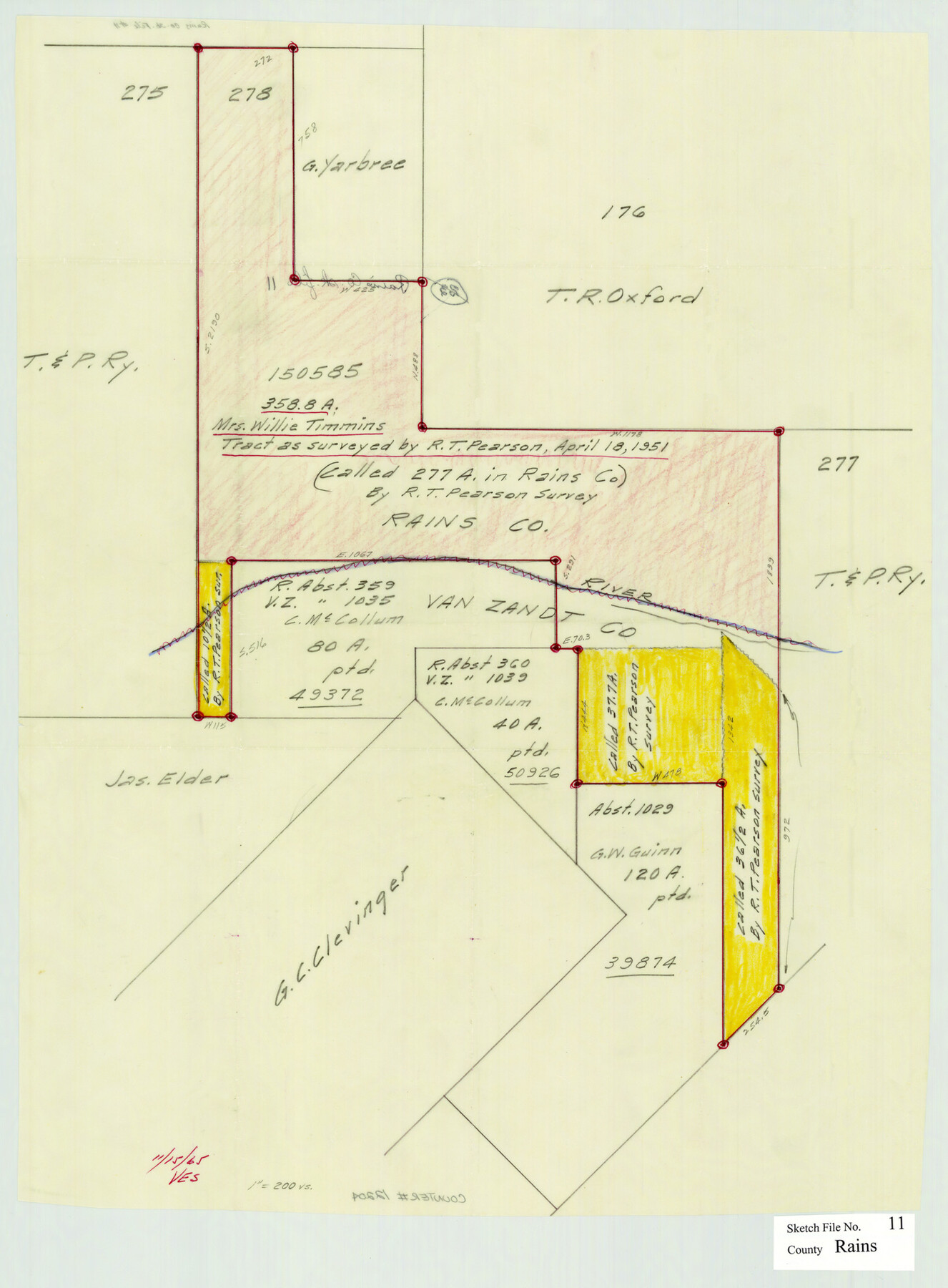
[Sketch showing survey 278 and surrounding area in the south part of Rains County and extending into Van Zandt County]
-
Map/Doc
12204
-
Collection
General Map Collection
-
Object Dates
4/18/1951 (Survey Date)
-
People and Organizations
R.T. Pearson (Surveyor/Engineer)
-
Counties
Rains Van Zandt
-
Subjects
Surveying Sketch File
-
Height x Width
21.1 x 15.5 inches
53.6 x 39.4 cm
-
Medium
paper, manuscript
-
Scale
1" = 200 varas
-
Features
[Sabine] River
Part of: General Map Collection
McLennan County Sketch File 43

Print $4.00
- Digital $50.00
McLennan County Sketch File 43
1873
Size 10.0 x 8.1 inches
Map/Doc 31333
Lee County Working Sketch 11

Print $20.00
- Digital $50.00
Lee County Working Sketch 11
1980
Size 25.2 x 25.7 inches
Map/Doc 70390
Texas Gulf Coast, from the Sabine River to the Rio Grande as Subdivided for Mineral Development; Aransas, Nueces, Kleberg, Kenedy, Willacy, and Cameron Counties

Print $40.00
- Digital $50.00
Texas Gulf Coast, from the Sabine River to the Rio Grande as Subdivided for Mineral Development; Aransas, Nueces, Kleberg, Kenedy, Willacy, and Cameron Counties
1976
Size 118.0 x 43.0 inches
Map/Doc 1940
Foard County Working Sketch 2

Print $20.00
- Digital $50.00
Foard County Working Sketch 2
1911
Size 26.3 x 41.4 inches
Map/Doc 69192
Freestone County Boundary File 30

Print $8.00
- Digital $50.00
Freestone County Boundary File 30
Size 10.7 x 8.3 inches
Map/Doc 53588
Starr County Sketch File 22

Print $20.00
- Digital $50.00
Starr County Sketch File 22
1922
Size 16.4 x 35.9 inches
Map/Doc 12331
Harris County Working Sketch 88

Print $20.00
- Digital $50.00
Harris County Working Sketch 88
1972
Size 30.3 x 38.4 inches
Map/Doc 65980
Fayette County

Print $40.00
- Digital $50.00
Fayette County
1978
Size 42.5 x 54.7 inches
Map/Doc 73146
El Paso County Rolled Sketch 50

Print $40.00
- Digital $50.00
El Paso County Rolled Sketch 50
Size 19.7 x 76.0 inches
Map/Doc 76430
Live Oak County Working Sketch 21

Print $20.00
- Digital $50.00
Live Oak County Working Sketch 21
1964
Size 30.8 x 33.9 inches
Map/Doc 70606
Texas Gulf Coast Map from the Sabine River to the Rio Grande as subdivided for mineral development

Print $40.00
- Digital $50.00
Texas Gulf Coast Map from the Sabine River to the Rio Grande as subdivided for mineral development
1948
Size 48.9 x 38.0 inches
Map/Doc 2910
Outer Continental Shelf Leasing Maps (Louisiana Offshore Operations)

Print $20.00
- Digital $50.00
Outer Continental Shelf Leasing Maps (Louisiana Offshore Operations)
1955
Size 8.8 x 10.0 inches
Map/Doc 76091
You may also like
Brewster County Rolled Sketch 28

Print $20.00
- Digital $50.00
Brewster County Rolled Sketch 28
1910
Size 25.6 x 29.4 inches
Map/Doc 5215
Llano County Boundary File 1

Print $10.00
- Digital $50.00
Llano County Boundary File 1
Size 8.7 x 4.0 inches
Map/Doc 56425
Uvalde County Working Sketch 67

Print $20.00
- Digital $50.00
Uvalde County Working Sketch 67
2016
Size 24.4 x 36.6 inches
Map/Doc 94082
Culberson County Sketch File 26

Print $8.00
- Digital $50.00
Culberson County Sketch File 26
1949
Size 11.2 x 8.8 inches
Map/Doc 20262
[Atlas A, Table of Contents, part 2]
![82085, [Atlas A, Table of Contents, part 2], General Map Collection](https://historictexasmaps.com/wmedia_w700/maps/82085.tif.jpg)
Print $2.00
- Digital $50.00
[Atlas A, Table of Contents, part 2]
Size 7.0 x 11.8 inches
Map/Doc 82085
Map of Goliad County

Print $20.00
- Digital $50.00
Map of Goliad County
1853
Size 30.7 x 24.2 inches
Map/Doc 3585
Colorado River, Pinoak Creek Sheet

Print $6.00
- Digital $50.00
Colorado River, Pinoak Creek Sheet
1941
Size 27.5 x 35.2 inches
Map/Doc 65312
Ward County Working Sketch 41

Print $20.00
- Digital $50.00
Ward County Working Sketch 41
1969
Size 45.3 x 31.7 inches
Map/Doc 72347
Maps of Gulf Intracoastal Waterway, Texas - Sabine River to the Rio Grande and connecting waterways including ship channels

Print $20.00
- Digital $50.00
Maps of Gulf Intracoastal Waterway, Texas - Sabine River to the Rio Grande and connecting waterways including ship channels
1966
Size 14.6 x 22.2 inches
Map/Doc 61971
Flight Mission No. BQR-4K, Frame 69, Brazoria County

Print $20.00
- Digital $50.00
Flight Mission No. BQR-4K, Frame 69, Brazoria County
1952
Size 18.7 x 22.4 inches
Map/Doc 84002
Ward County Working Sketch 23

Print $40.00
- Digital $50.00
Ward County Working Sketch 23
1953
Size 29.1 x 59.5 inches
Map/Doc 72329
Red River County Working Sketch 38

Print $20.00
- Digital $50.00
Red River County Working Sketch 38
1965
Size 24.0 x 24.9 inches
Map/Doc 72021