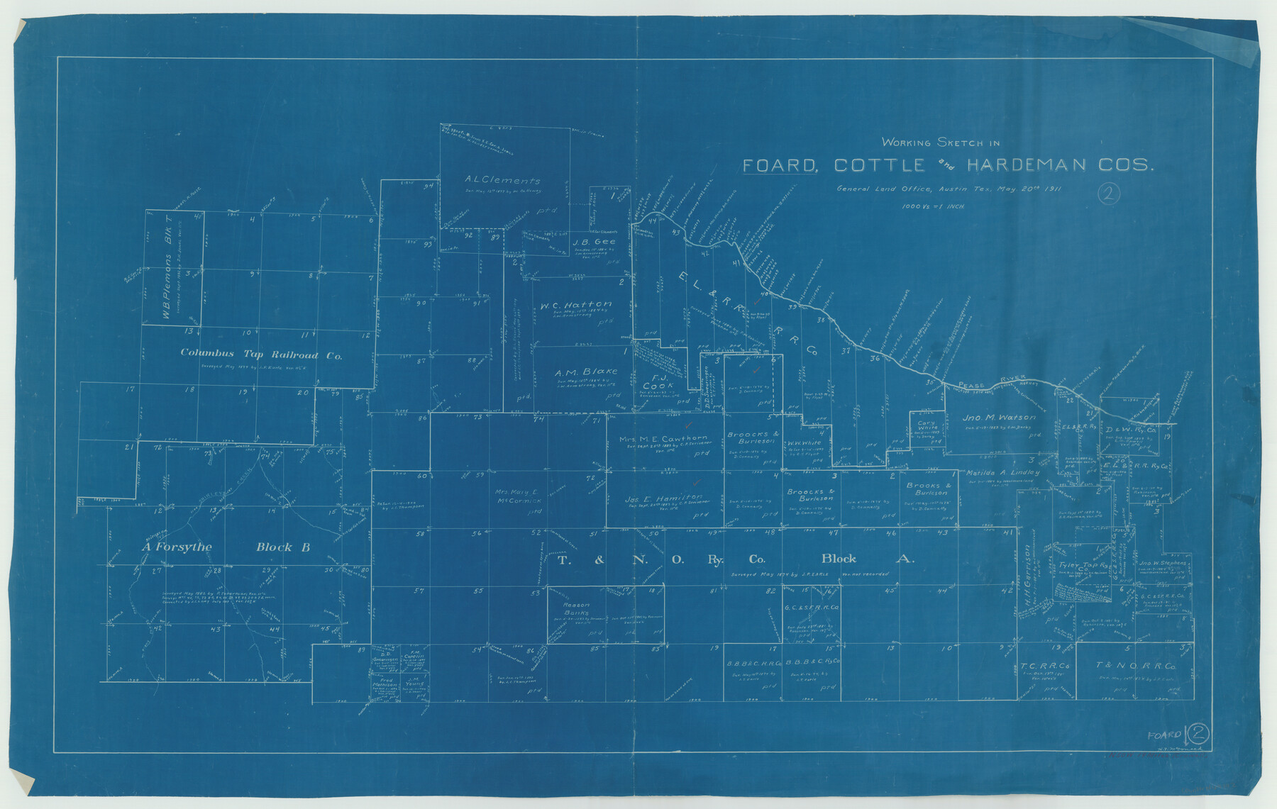
Foard County Working Sketch 2
-
Map/Doc
69192
-
Collection
General Map Collection
-
Object Dates
5/20/1911 (Creation Date)
-
People and Organizations
H.F. McDonald (Draftsman)
-
Counties
Foard Cottle Hardeman
-
Subjects
Surveying Working Sketch
-
Height x Width
26.3 x 41.4 inches
66.8 x 105.2 cm
-
Scale
1" = 1000 varas
Part of: General Map Collection
King County Working Sketch 9

Print $20.00
- Digital $50.00
King County Working Sketch 9
1955
Size 34.1 x 22.7 inches
Map/Doc 70173
Victoria County Rolled Sketch 9

Print $20.00
- Digital $50.00
Victoria County Rolled Sketch 9
Size 24.1 x 36.1 inches
Map/Doc 95400
[Map of Hardin County]
![3630, [Map of Hardin County], General Map Collection](https://historictexasmaps.com/wmedia_w700/maps/3630-2.tif.jpg)
Print $20.00
- Digital $50.00
[Map of Hardin County]
1862
Size 18.0 x 22.0 inches
Map/Doc 3630
Bowie County Sketch File 6d

Print $4.00
- Digital $50.00
Bowie County Sketch File 6d
1927
Size 11.4 x 9.0 inches
Map/Doc 14850
Field Notes for the Remonumentation of the Northwest Corner of the State of Texas by the Department of the Interior

Print $38.00
Field Notes for the Remonumentation of the Northwest Corner of the State of Texas by the Department of the Interior
1991
Map/Doc 81687
Medina County Sketch File 1

Print $4.00
- Digital $50.00
Medina County Sketch File 1
Size 12.5 x 8.1 inches
Map/Doc 31437
Fisher County Sketch File 3

Print $56.00
- Digital $50.00
Fisher County Sketch File 3
1886
Size 8.9 x 5.8 inches
Map/Doc 22549
Calhoun County Rolled Sketch 8

Print $40.00
- Digital $50.00
Calhoun County Rolled Sketch 8
1921
Size 25.6 x 53.4 inches
Map/Doc 5364
Flight Mission No. CLL-1N, Frame 191, Willacy County

Print $20.00
- Digital $50.00
Flight Mission No. CLL-1N, Frame 191, Willacy County
1954
Size 18.3 x 22.0 inches
Map/Doc 87061
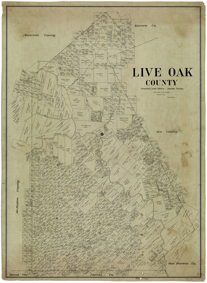
Live Oak County
Print $40.00
- Digital $50.00
Live Oak County
1899
Size 51.5 x 38.4 inches
Map/Doc 5018
Terry County Sketch File 3

Print $20.00
- Digital $50.00
Terry County Sketch File 3
1948
Size 16.2 x 39.0 inches
Map/Doc 10390
Briscoe County Sketch File H-1

Print $40.00
- Digital $50.00
Briscoe County Sketch File H-1
Size 21.7 x 18.2 inches
Map/Doc 11006
You may also like
Pecos County Working Sketch 120

Print $20.00
- Digital $50.00
Pecos County Working Sketch 120
1973
Size 34.7 x 29.1 inches
Map/Doc 71593
Flight Mission No. DCL-7C, Frame 46, Kenedy County

Print $20.00
- Digital $50.00
Flight Mission No. DCL-7C, Frame 46, Kenedy County
1943
Size 15.4 x 15.3 inches
Map/Doc 86034
General Highway Map, Moore County, Texas

Print $20.00
General Highway Map, Moore County, Texas
1961
Size 18.1 x 24.5 inches
Map/Doc 79604
Bird's Eye View of the City of Brenham, Washington County, Texas

Print $20.00
Bird's Eye View of the City of Brenham, Washington County, Texas
1881
Size 19.4 x 26.7 inches
Map/Doc 89076
Caldwell County Sketch File 5

Print $8.00
- Digital $50.00
Caldwell County Sketch File 5
Size 14.1 x 8.6 inches
Map/Doc 35843
Loving County Working Sketch 16

Print $40.00
- Digital $50.00
Loving County Working Sketch 16
1973
Size 33.3 x 54.1 inches
Map/Doc 70649
Pecos County Sketch File 93

Print $46.00
- Digital $50.00
Pecos County Sketch File 93
1955
Size 9.6 x 8.3 inches
Map/Doc 33990
Edwards County

Print $40.00
- Digital $50.00
Edwards County
1900
Size 56.3 x 59.5 inches
Map/Doc 66810
Dallam County Working Sketch 3

Print $20.00
- Digital $50.00
Dallam County Working Sketch 3
1960
Size 13.8 x 30.5 inches
Map/Doc 68588
Flight Mission No. BRA-16M, Frame 129, Jefferson County

Print $20.00
- Digital $50.00
Flight Mission No. BRA-16M, Frame 129, Jefferson County
1953
Size 18.4 x 22.7 inches
Map/Doc 85739
Travis County Rolled Sketch 34

Print $20.00
- Digital $50.00
Travis County Rolled Sketch 34
1949
Size 22.9 x 25.2 inches
Map/Doc 8035
Travis County Appraisal District Plat Map 2_3215

Print $20.00
- Digital $50.00
Travis County Appraisal District Plat Map 2_3215
Size 21.5 x 26.4 inches
Map/Doc 94222