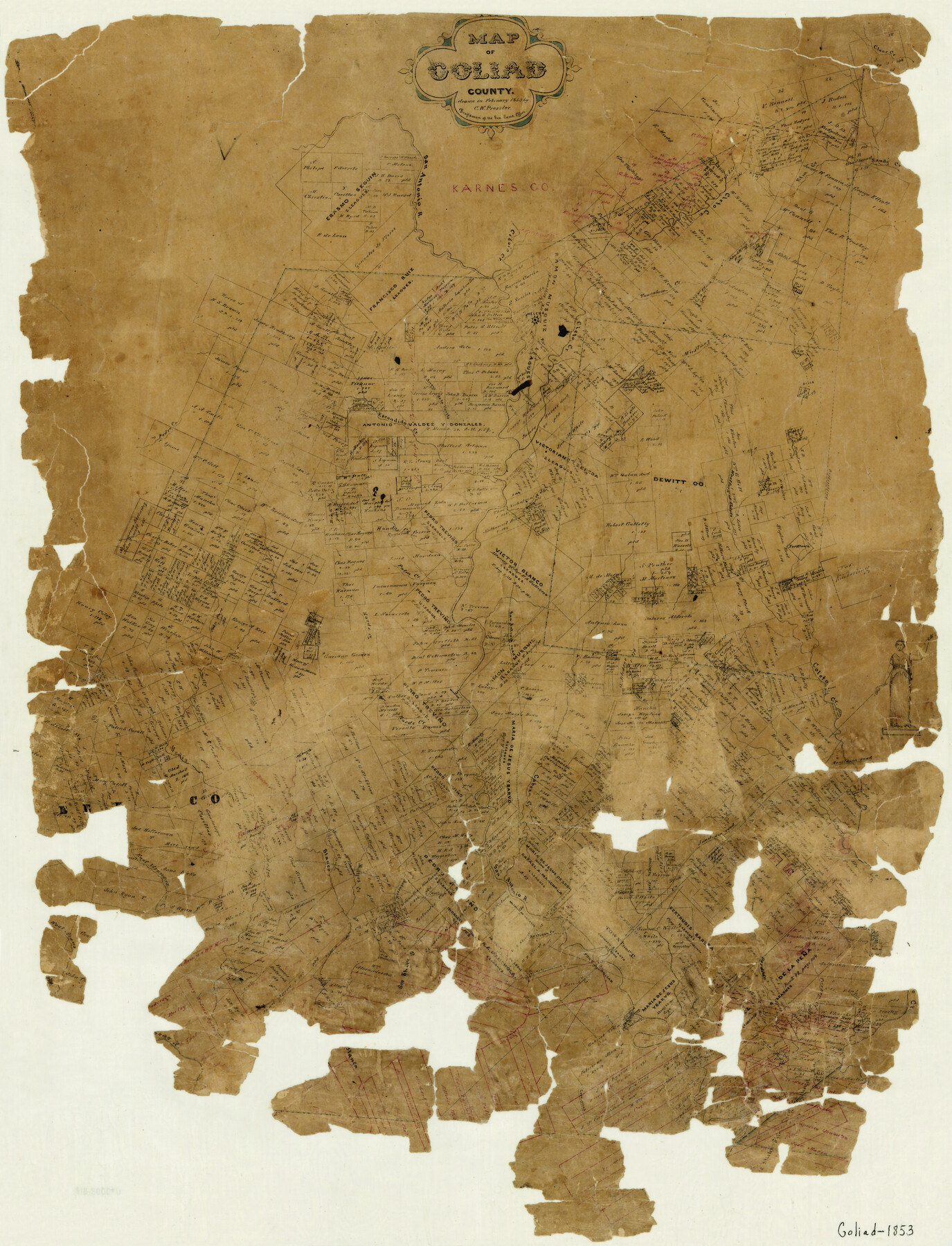
Map of Goliad County
-
Map/Doc
3585
-
Collection
General Map Collection
-
Object Dates
2/1853 (Creation Date)
-
People and Organizations
Chas. W. Pressler (Draftsman)
-
Counties
Goliad
-
Subjects
County
-
Height x Width
30.7 x 24.2 inches
78.0 x 61.5 cm
-
Features
Mocorera Creek
Middle Creek
Hords Creek
Perdido Creek
Turkey Creek
Wintergreen
Espiritu Santo Mission
Fort Goliad
Goliad
Goliad
Rosario Mission
Martinez Creek
Matamoros [Road]
Mier Road
Medio Creek
Millers Creek
Coleto Creek
Richland Bayou
East Aransas River
West Aransas River
[Aran]sas River
Blanco River
Sarco Creek
Copano Road
Chain Creek
Pestosk Creek
Fish Creek
Victoria Road
Escondido Creek
Cleto Creek
Elm Creek
Clear Creek
Sandy Creek
Toncahua Creek
Timber Creek
Cibolo Creek
Helena
Arroyo de la Parite
Strickland Creek
Mustang Creek
East Fork of Coleto Creek
Ojo de Agua Creek
San Antonio River
Hondo Creek
Panther Branch of Escondido Creek
Pedro Creek
Kard's Creek
Palm Creek
San Antonio Road
Jane Creek
Yorktown
Anastasia Road
West Fork of Coleto Creek
Goat Creek
Cabeza Creek
Purista Creek
Part of: General Map Collection
Jasper County Sketch File 19

Print $6.00
- Digital $50.00
Jasper County Sketch File 19
1890
Size 14.2 x 8.8 inches
Map/Doc 27815
Central America II. Including Texas, California and the Northern States of Mexico

Print $20.00
- Digital $50.00
Central America II. Including Texas, California and the Northern States of Mexico
1842
Size 14.1 x 16.7 inches
Map/Doc 93927
Wilbarger County Working Sketch 14

Print $20.00
- Digital $50.00
Wilbarger County Working Sketch 14
1955
Size 24.8 x 21.7 inches
Map/Doc 72552

Medina County Working Sketch 33

Print $20.00
- Digital $50.00
Medina County Working Sketch 33
2006
Size 34.5 x 40.0 inches
Map/Doc 83607
San Luis Pass to East Matagorda Bay

Print $20.00
- Digital $50.00
San Luis Pass to East Matagorda Bay
1964
Size 34.7 x 46.6 inches
Map/Doc 69964
Flight Mission No. DCL-7C, Frame 20, Kenedy County

Print $20.00
- Digital $50.00
Flight Mission No. DCL-7C, Frame 20, Kenedy County
1943
Size 15.5 x 15.1 inches
Map/Doc 86012
Duval County Rolled Sketch 32

Print $20.00
- Digital $50.00
Duval County Rolled Sketch 32
Size 38.5 x 37.3 inches
Map/Doc 8817
Fannin County Working Sketch 9

Print $20.00
- Digital $50.00
Fannin County Working Sketch 9
1973
Size 28.1 x 21.9 inches
Map/Doc 69163
Map of Austin County

Print $20.00
- Digital $50.00
Map of Austin County
1863
Size 25.7 x 29.8 inches
Map/Doc 3253
Menard County Working Sketch 4

Print $20.00
- Digital $50.00
Menard County Working Sketch 4
1914
Size 19.8 x 16.2 inches
Map/Doc 70951
Maps of Gulf Intracoastal Waterway, Texas - Sabine River to the Rio Grande and connecting waterways including ship channels

Print $20.00
- Digital $50.00
Maps of Gulf Intracoastal Waterway, Texas - Sabine River to the Rio Grande and connecting waterways including ship channels
1966
Size 14.5 x 22.4 inches
Map/Doc 61951
You may also like
Zavala County Rolled Sketch 12

Print $20.00
- Digital $50.00
Zavala County Rolled Sketch 12
Size 33.4 x 21.0 inches
Map/Doc 8320
Map of the city of San Antonio, Bexar County, Texas including suburbs both north and south

Print $20.00
Map of the city of San Antonio, Bexar County, Texas including suburbs both north and south
1924
Size 37.0 x 24.5 inches
Map/Doc 93556
Flight Mission No. BRA-3M, Frame 122, Jefferson County

Print $20.00
- Digital $50.00
Flight Mission No. BRA-3M, Frame 122, Jefferson County
1953
Size 18.7 x 22.3 inches
Map/Doc 85396
Presidio County Rolled Sketch 83B

Print $20.00
- Digital $50.00
Presidio County Rolled Sketch 83B
Size 16.6 x 23.0 inches
Map/Doc 2061
General Highway Map Bailey County, Texas

Print $20.00
- Digital $50.00
General Highway Map Bailey County, Texas
1948
Size 18.7 x 25.8 inches
Map/Doc 92533
Erath County Sketch File 22

Print $4.00
- Digital $50.00
Erath County Sketch File 22
1853
Size 8.4 x 8.4 inches
Map/Doc 22304
Cass County Rolled Sketch 5B

Print $20.00
- Digital $50.00
Cass County Rolled Sketch 5B
1949
Size 23.5 x 16.4 inches
Map/Doc 5412
Map of Sherman County

Print $20.00
- Digital $50.00
Map of Sherman County
1902
Size 40.9 x 36.6 inches
Map/Doc 16815
Bravo Deed, Instrument 24, Tract A and Tract B

Print $3.00
- Digital $50.00
Bravo Deed, Instrument 24, Tract A and Tract B
Size 10.6 x 13.2 inches
Map/Doc 91478
Baylor County Sketch File A3

Print $14.00
- Digital $50.00
Baylor County Sketch File A3
1899
Size 11.4 x 8.7 inches
Map/Doc 14077
Starr County Working Sketch 11

Print $20.00
- Digital $50.00
Starr County Working Sketch 11
1944
Size 18.1 x 17.7 inches
Map/Doc 63927
Henderson County Working Sketch 20

Print $20.00
- Digital $50.00
Henderson County Working Sketch 20
1947
Size 31.6 x 18.9 inches
Map/Doc 66153