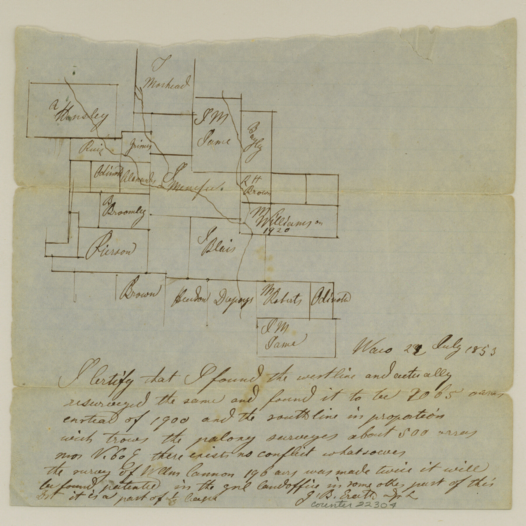
Erath County Sketch File 22
[Sketch of surveys around the Menefee survey]
-
Map/Doc
22304
-
Collection
General Map Collection
-
Object Dates
1853/7/29 (Creation Date)
-
People and Organizations
J.B. Erath (Surveyor/Engineer)
-
Counties
Erath
-
Subjects
Surveying Sketch File
-
Height x Width
8.4 x 8.4 inches
21.3 x 21.3 cm
-
Medium
paper, manuscript
Part of: General Map Collection
[Bastrop District]
![83006, [Bastrop District], General Map Collection](https://historictexasmaps.com/wmedia_w700/maps/83006-1.tif.jpg)
Print $40.00
- Digital $50.00
[Bastrop District]
1895
Size 71.8 x 52.3 inches
Map/Doc 83006
Jefferson County Sketch File 19

Print $20.00
- Digital $50.00
Jefferson County Sketch File 19
1872
Size 15.0 x 20.1 inches
Map/Doc 11870
Runnels County Working Sketch 30b

Print $20.00
- Digital $50.00
Runnels County Working Sketch 30b
Size 23.2 x 25.3 inches
Map/Doc 63627
Foard County Working Sketch 9

Print $20.00
- Digital $50.00
Foard County Working Sketch 9
1977
Size 47.0 x 27.2 inches
Map/Doc 69200
Reagan County Working Sketch 27

Print $20.00
- Digital $50.00
Reagan County Working Sketch 27
1960
Size 33.0 x 42.5 inches
Map/Doc 71869
Central America Past and Present

Central America Past and Present
1986
Size 20.6 x 31.6 inches
Map/Doc 96839
Presidio County Sketch File 35B

Print $20.00
- Digital $50.00
Presidio County Sketch File 35B
1906
Size 11.8 x 20.7 inches
Map/Doc 11714
Falls County Boundary File 1a

Print $56.00
- Digital $50.00
Falls County Boundary File 1a
1888
Size 14.6 x 9.2 inches
Map/Doc 53253
Cottle County Rolled Sketch 7

Print $20.00
- Digital $50.00
Cottle County Rolled Sketch 7
Size 36.8 x 33.0 inches
Map/Doc 8675
Flight Mission No. DIX-5P, Frame 143, Aransas County

Print $20.00
- Digital $50.00
Flight Mission No. DIX-5P, Frame 143, Aransas County
1956
Size 17.0 x 17.1 inches
Map/Doc 83804
Map of the State of Texas

Print $40.00
- Digital $50.00
Map of the State of Texas
1879
Size 102.7 x 57.6 inches
Map/Doc 93383
Presidio County Working Sketch 25

Print $20.00
- Digital $50.00
Presidio County Working Sketch 25
1945
Size 22.8 x 18.9 inches
Map/Doc 71701
You may also like
Liberty County Sketch File 68

Print $24.00
- Digital $50.00
Liberty County Sketch File 68
Size 11.0 x 8.5 inches
Map/Doc 94021
Concho County Working Sketch 3

Print $20.00
- Digital $50.00
Concho County Working Sketch 3
1918
Size 24.0 x 22.2 inches
Map/Doc 68185
Smith's Atlas designed to accompany the Geography

Print $352.00
- Digital $50.00
Smith's Atlas designed to accompany the Geography
1850
Size 12.2 x 10.0 inches
Map/Doc 93881
[Rio Grande & Eagle Pass - Stockdale to Cuero]
![64049, [Rio Grande & Eagle Pass - Stockdale to Cuero], General Map Collection](https://historictexasmaps.com/wmedia_w700/maps/64049.tif.jpg)
Print $40.00
- Digital $50.00
[Rio Grande & Eagle Pass - Stockdale to Cuero]
Size 19.1 x 98.7 inches
Map/Doc 64049
Comanche County Sketch File 7

Print $6.00
- Digital $50.00
Comanche County Sketch File 7
1852
Size 9.9 x 8.1 inches
Map/Doc 19063
Rusk County Sketch File 19

Print $4.00
Rusk County Sketch File 19
Size 13.0 x 8.2 inches
Map/Doc 35526
Travis County Working Sketch 44

Print $20.00
- Digital $50.00
Travis County Working Sketch 44
1974
Size 22.3 x 26.4 inches
Map/Doc 69428
Map of Cooke County

Print $20.00
- Digital $50.00
Map of Cooke County
1857
Size 34.1 x 37.9 inches
Map/Doc 1973
Jackson County Rolled Sketch 6

Print $20.00
- Digital $50.00
Jackson County Rolled Sketch 6
1914
Size 23.6 x 26.6 inches
Map/Doc 6341
Brazoria County Sketch File 28

Print $6.00
- Digital $50.00
Brazoria County Sketch File 28
1889
Size 8.8 x 14.2 inches
Map/Doc 15030
Flight Mission No. DAG-19K, Frame 63, Matagorda County

Print $20.00
- Digital $50.00
Flight Mission No. DAG-19K, Frame 63, Matagorda County
1952
Size 16.1 x 16.1 inches
Map/Doc 86390
Blanco County Boundary File 1

Print $20.00
- Digital $50.00
Blanco County Boundary File 1
Size 11.6 x 23.1 inches
Map/Doc 50539