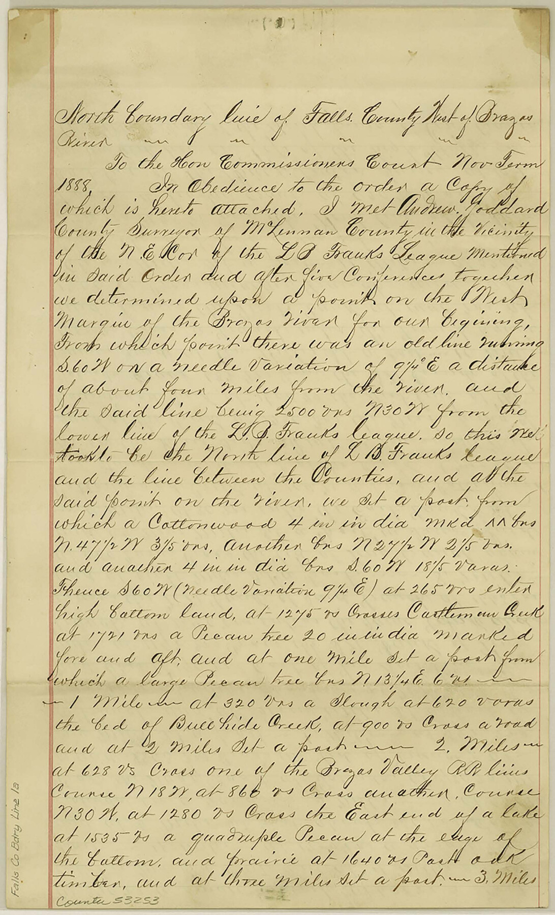
Falls County Boundary File 1a
County line between Falls, Fannin and Grayson Counties
-
Map/Doc
53253
-
Collection
General Map Collection
-
Object Dates
1888/11/12 (Creation Date)
1889/3/3 (File Date)
-
People and Organizations
Robt. S. Hunnicutt (Surveyor/Engineer)
-
Counties
Fannin Grayson Falls
-
Subjects
County Boundaries
-
Height x Width
14.6 x 9.2 inches
37.1 x 23.4 cm
-
Medium
paper, manuscript
Part of: General Map Collection
Orange County Working Sketch Graphic Index - sheet A

Print $20.00
- Digital $50.00
Orange County Working Sketch Graphic Index - sheet A
1921
Size 24.4 x 29.3 inches
Map/Doc 76658
Sutton County Working Sketch 68
Print $40.00
- Digital $50.00
Sutton County Working Sketch 68
1972
Size 61.2 x 37.4 inches
Map/Doc 62411
Aransas County Rolled Sketch 31A

Print $20.00
- Digital $50.00
Aransas County Rolled Sketch 31A
1950
Size 25.1 x 42.4 inches
Map/Doc 77499
The Woodlands, a real hometown for people and companies

The Woodlands, a real hometown for people and companies
Size 39.7 x 26.4 inches
Map/Doc 94288
Angelina County Sketch File 11a

Print $4.00
- Digital $50.00
Angelina County Sketch File 11a
1860
Size 14.4 x 8.3 inches
Map/Doc 12942
Harbor Pass and Bar at Brazos Santiago, Texas

Print $20.00
- Digital $50.00
Harbor Pass and Bar at Brazos Santiago, Texas
1879
Size 18.1 x 27.4 inches
Map/Doc 73002
Trinity County Sketch File 1

Print $4.00
- Digital $50.00
Trinity County Sketch File 1
1855
Size 8.3 x 8.2 inches
Map/Doc 38488
Map of Kendall County

Print $20.00
- Digital $50.00
Map of Kendall County
1862
Size 21.0 x 20.0 inches
Map/Doc 3754
Flight Mission No. BRA-16M, Frame 97, Jefferson County

Print $20.00
- Digital $50.00
Flight Mission No. BRA-16M, Frame 97, Jefferson County
1953
Size 18.5 x 22.4 inches
Map/Doc 85709
Galveston County NRC Article 33.136 Sketch 62

Print $28.00
- Digital $50.00
Galveston County NRC Article 33.136 Sketch 62
2009
Size 24.0 x 36.0 inches
Map/Doc 94596
Gaines County Rolled Sketch 7

Print $40.00
- Digital $50.00
Gaines County Rolled Sketch 7
1915
Size 35.7 x 54.0 inches
Map/Doc 9014
Amistad International Reservoir on Rio Grande 108

Print $20.00
- Digital $50.00
Amistad International Reservoir on Rio Grande 108
1950
Size 28.5 x 40.9 inches
Map/Doc 75539
You may also like
[Surveys in the Jefferson District]
![3177, [Surveys in the Jefferson District], General Map Collection](https://historictexasmaps.com/wmedia_w700/maps/3177.tif.jpg)
Print $2.00
- Digital $50.00
[Surveys in the Jefferson District]
1841
Size 9.8 x 8.0 inches
Map/Doc 3177
Palo Pinto County Boundary File 4a

Print $34.00
- Digital $50.00
Palo Pinto County Boundary File 4a
Size 13.3 x 8.9 inches
Map/Doc 57817
Tom Green County Working Sketch 11
Print $20.00
- Digital $50.00
Tom Green County Working Sketch 11
1968
Size 33.9 x 39.2 inches
Map/Doc 69380
Bowie County Rolled Sketch 1

Print $20.00
- Digital $50.00
Bowie County Rolled Sketch 1
1965
Size 32.0 x 46.1 inches
Map/Doc 8927
Zavala County Rolled Sketch 18

Print $20.00
- Digital $50.00
Zavala County Rolled Sketch 18
Size 39.4 x 27.3 inches
Map/Doc 8322
La Salle County Sketch File 9

Print $4.00
- Digital $50.00
La Salle County Sketch File 9
Size 6.3 x 8.3 inches
Map/Doc 29458
Myrick Farms Lubbock & Hockley Counties

Print $20.00
- Digital $50.00
Myrick Farms Lubbock & Hockley Counties
Size 21.3 x 21.5 inches
Map/Doc 92830
Old Miscellaneous File 34

Print $4.00
- Digital $50.00
Old Miscellaneous File 34
1881
Size 9.8 x 8.0 inches
Map/Doc 75755
Haskell County Working Sketch 3

Print $20.00
- Digital $50.00
Haskell County Working Sketch 3
1920
Size 41.4 x 21.9 inches
Map/Doc 66061
Duval County Working Sketch 33

Print $20.00
- Digital $50.00
Duval County Working Sketch 33
1951
Size 21.9 x 23.3 inches
Map/Doc 68757
Pecos County Sketch File 76

Print $4.00
- Digital $50.00
Pecos County Sketch File 76
1943
Size 11.2 x 8.8 inches
Map/Doc 33907
Shelby County Rolled Sketch 15

Print $40.00
- Digital $50.00
Shelby County Rolled Sketch 15
1948
Size 22.8 x 54.4 inches
Map/Doc 10313