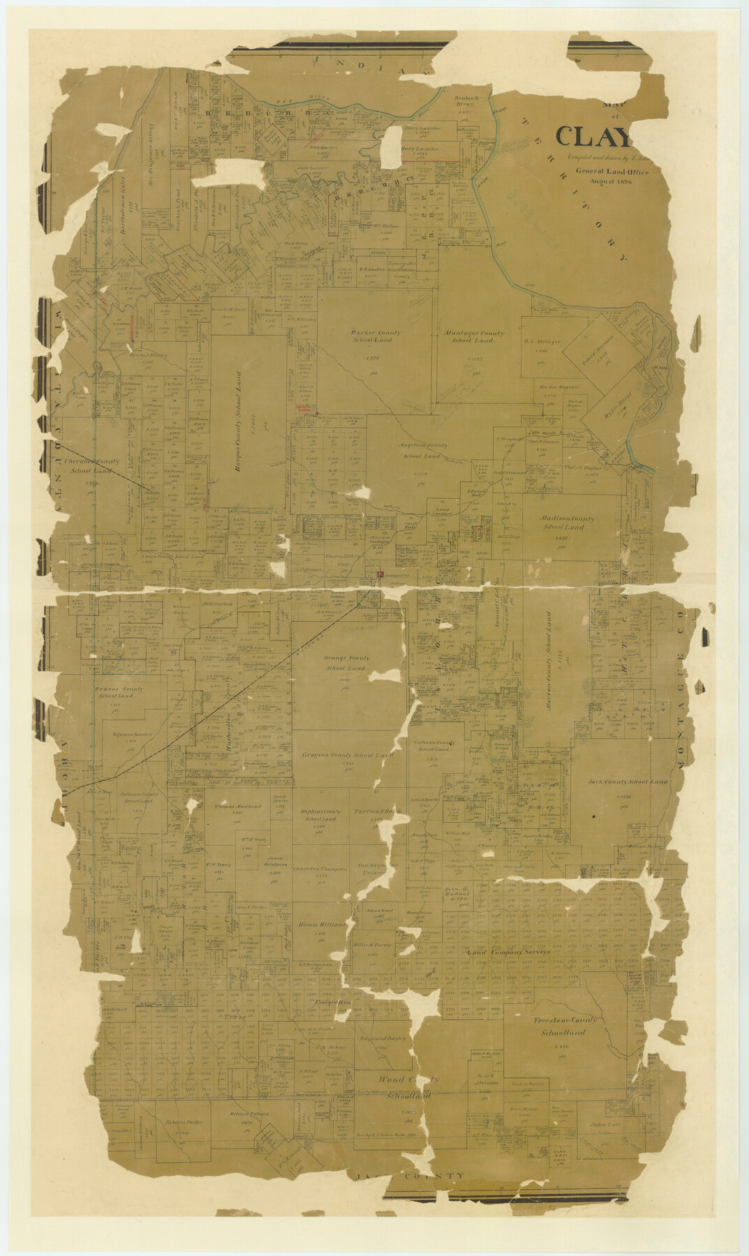
Clay Co.
-
Map/Doc
4745
-
Collection
General Map Collection
-
Object Dates
1924 (Creation Date)
-
People and Organizations
Texas General Land Office (Publisher)
C.C. Morris (Compiler)
C.C. Morris (Draftsman)
-
Counties
Clay
-
Subjects
County
-
Height x Width
53.8 x 34.6 inches
136.7 x 87.9 cm
-
Comments
Conservation funded in 2007 by Friends of the Texas General Land Office.
-
Features
Russell's Creek
WF&O
FW&DC
Dickworsham
Kola
Bellevue
Joy
Blue Grove
Huggins
Halsel
Edwards
Jolly
Charlie
Petrolia
Dean
Red River
Contrary Creek
Freestone Creek
Deer Creek
RR&SW
South fork of Little Wichita River
Duck Creek
Henrietta
Valley Creek
Turkey Creek
South Fork of Valley Creek
Little Wichita River
Byers
Big Wichita River
Part of: General Map Collection
Sabine River, Free Bridge Sheet

Print $40.00
- Digital $50.00
Sabine River, Free Bridge Sheet
1936
Size 27.2 x 50.6 inches
Map/Doc 65143
Hudspeth County Working Sketch 42

Print $20.00
- Digital $50.00
Hudspeth County Working Sketch 42
1981
Size 34.2 x 36.5 inches
Map/Doc 66327
Crockett County Sketch File 84

Print $6.00
- Digital $50.00
Crockett County Sketch File 84
1942
Size 11.4 x 8.9 inches
Map/Doc 19905
Floyd County Sketch File 15

Print $12.00
- Digital $50.00
Floyd County Sketch File 15
1913
Size 10.9 x 7.3 inches
Map/Doc 22736
Potter County

Print $20.00
- Digital $50.00
Potter County
1909
Size 47.3 x 41.0 inches
Map/Doc 66983
Edwards County Rolled Sketch 17

Print $20.00
- Digital $50.00
Edwards County Rolled Sketch 17
1945
Size 27.6 x 19.4 inches
Map/Doc 5806
Brazos River, Washington Sheet

Print $6.00
- Digital $50.00
Brazos River, Washington Sheet
1936
Size 30.4 x 24.7 inches
Map/Doc 65277
Trinity County Sketch File 6

Print $6.00
- Digital $50.00
Trinity County Sketch File 6
Size 16.2 x 10.2 inches
Map/Doc 38508
Travis County Rolled Sketch 56

Print $20.00
- Digital $50.00
Travis County Rolled Sketch 56
1885
Size 16.7 x 23.2 inches
Map/Doc 8047
Edwards County Rolled Sketch 33

Print $20.00
- Digital $50.00
Edwards County Rolled Sketch 33
1890
Size 25.0 x 25.8 inches
Map/Doc 5815
Val Verde County Working Sketch 60

Print $20.00
- Digital $50.00
Val Verde County Working Sketch 60
1958
Size 32.1 x 32.4 inches
Map/Doc 72195
Flight Mission No. DQO-8K, Frame 89, Galveston County

Print $20.00
- Digital $50.00
Flight Mission No. DQO-8K, Frame 89, Galveston County
1952
Size 18.6 x 22.4 inches
Map/Doc 85191
You may also like
Andrews County Working Sketch 14

Print $40.00
- Digital $50.00
Andrews County Working Sketch 14
1957
Size 61.6 x 37.1 inches
Map/Doc 67060
Culberson County Working Sketch 52

Print $20.00
- Digital $50.00
Culberson County Working Sketch 52
1972
Size 37.3 x 39.5 inches
Map/Doc 68506
Fort Bend Co.

Print $20.00
- Digital $50.00
Fort Bend Co.
1931
Size 39.1 x 40.8 inches
Map/Doc 73150

Motley County Working Sketch 3

Print $20.00
- Digital $50.00
Motley County Working Sketch 3
1914
Size 13.2 x 20.4 inches
Map/Doc 71208
Texas, San Antonio Bay, Guadalupe Bay

Print $40.00
- Digital $50.00
Texas, San Antonio Bay, Guadalupe Bay
1934
Size 28.8 x 48.4 inches
Map/Doc 69999
Bandera County Working Sketch 23

Print $20.00
- Digital $50.00
Bandera County Working Sketch 23
1950
Size 35.8 x 29.6 inches
Map/Doc 67619
Milam County Boundary File 6

Print $16.00
- Digital $50.00
Milam County Boundary File 6
Size 8.8 x 14.5 inches
Map/Doc 57240
Pecos County Rolled Sketch 69A

Print $20.00
- Digital $50.00
Pecos County Rolled Sketch 69A
1928
Size 44.3 x 35.9 inches
Map/Doc 9702
Hutchinson County Sketch File 10

Print $40.00
- Digital $50.00
Hutchinson County Sketch File 10
Size 55.8 x 9.2 inches
Map/Doc 10500
Tyler County Boundary File 89

Print $28.00
- Digital $50.00
Tyler County Boundary File 89
Size 9.2 x 7.2 inches
Map/Doc 59495
Burleson County Working Sketch 43

Print $20.00
- Digital $50.00
Burleson County Working Sketch 43
1991
Size 35.8 x 14.1 inches
Map/Doc 67762