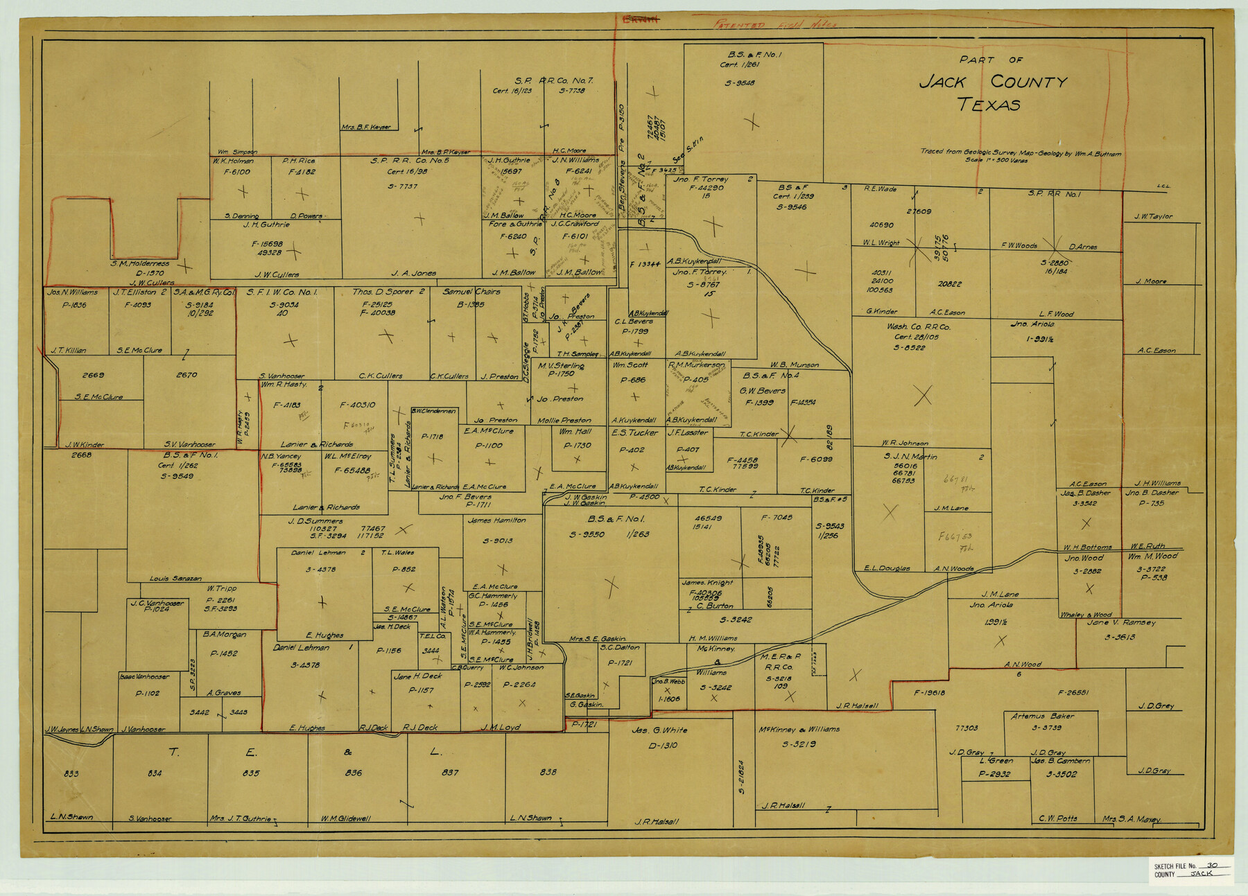
Jack County Sketch File 30
Copy of a part of Geological map of Jack Co.
-
Map/Doc
11829
-
Collection
General Map Collection
-
People and Organizations
William A. Buttram (Surveyor/Engineer)
-
Counties
Jack
-
Subjects
Surveying Sketch File
-
Height x Width
24.9 x 34.7 inches
63.3 x 88.1 cm
-
Medium
paper, manuscript
-
Scale
1:500
Part of: General Map Collection

Nueces County Sketch File 53

Print $4.00
- Digital $50.00
Nueces County Sketch File 53
1903
Size 11.1 x 8.8 inches
Map/Doc 32863
Bexar County Working Sketch 1

Print $20.00
- Digital $50.00
Bexar County Working Sketch 1
1935
Size 36.7 x 47.8 inches
Map/Doc 67317
Webb County Working Sketch 32

Print $20.00
- Digital $50.00
Webb County Working Sketch 32
1937
Size 34.5 x 36.0 inches
Map/Doc 72397
Montgomery County Sketch File 30

Print $20.00
- Digital $50.00
Montgomery County Sketch File 30
Size 37.5 x 41.7 inches
Map/Doc 10549
Andrews County Sketch File 3

Print $46.00
- Digital $50.00
Andrews County Sketch File 3
1928
Size 33.0 x 36.6 inches
Map/Doc 10317
La Salle County Rolled Sketch 27

Print $20.00
- Digital $50.00
La Salle County Rolled Sketch 27
1979
Size 29.0 x 38.2 inches
Map/Doc 6588
Newton County Working Sketch 1

Print $20.00
- Digital $50.00
Newton County Working Sketch 1
Size 25.5 x 25.9 inches
Map/Doc 71247
Panola County Working Sketch 24

Print $20.00
- Digital $50.00
Panola County Working Sketch 24
1957
Map/Doc 71433
Fisher County Rolled Sketch 7

Print $20.00
- Digital $50.00
Fisher County Rolled Sketch 7
1873
Size 47.1 x 43.5 inches
Map/Doc 8891
Bosque County Sketch File 11

Print $4.00
- Digital $50.00
Bosque County Sketch File 11
1863
Size 10.2 x 8.3 inches
Map/Doc 14759
Montgomery County Sketch File 35

Print $8.00
- Digital $50.00
Montgomery County Sketch File 35
1953
Size 14.1 x 8.9 inches
Map/Doc 31908
You may also like
Flight Mission No. CUG-3P, Frame 81, Kleberg County

Print $20.00
- Digital $50.00
Flight Mission No. CUG-3P, Frame 81, Kleberg County
1956
Size 18.3 x 22.1 inches
Map/Doc 86256
Gaines County Rolled Sketch 20

Print $20.00
- Digital $50.00
Gaines County Rolled Sketch 20
1955
Size 30.1 x 37.2 inches
Map/Doc 5936
Flight Mission No. BQY-4M, Frame 36, Harris County

Print $20.00
- Digital $50.00
Flight Mission No. BQY-4M, Frame 36, Harris County
1953
Size 18.6 x 22.3 inches
Map/Doc 85251
Aransas County Aerial Photograph Index Sheet 4

Print $20.00
- Digital $50.00
Aransas County Aerial Photograph Index Sheet 4
1957
Size 23.6 x 16.1 inches
Map/Doc 83662
Pecos County Sketch File 47

Print $8.00
- Digital $50.00
Pecos County Sketch File 47
1935
Size 11.4 x 8.5 inches
Map/Doc 33759
Kerr County Rolled Sketch 19

Print $20.00
- Digital $50.00
Kerr County Rolled Sketch 19
1954
Size 43.4 x 28.4 inches
Map/Doc 6501
Flight Mission No. DAH-9M, Frame 87, Orange County

Print $20.00
- Digital $50.00
Flight Mission No. DAH-9M, Frame 87, Orange County
1953
Size 18.5 x 22.3 inches
Map/Doc 86851
Oldham County Surveyor's Oath of Office

Print $3.00
Oldham County Surveyor's Oath of Office
1881
Size 15.2 x 9.7 inches
Map/Doc 47716
Ward County Rolled Sketch 18

Print $20.00
- Digital $50.00
Ward County Rolled Sketch 18
1949
Size 31.6 x 34.0 inches
Map/Doc 10109
Jefferson County Rolled Sketch 46

Print $3.00
- Digital $50.00
Jefferson County Rolled Sketch 46
Size 15.7 x 10.0 inches
Map/Doc 9304
Trinity River, Crabtree Ferry Sheet

Print $20.00
- Digital $50.00
Trinity River, Crabtree Ferry Sheet
1922
Size 41.9 x 37.8 inches
Map/Doc 65186
[Sections 58 through 95]
![92478, [Sections 58 through 95], Twichell Survey Records](https://historictexasmaps.com/wmedia_w700/maps/92478-1.tif.jpg)
Print $20.00
- Digital $50.00
[Sections 58 through 95]
Size 23.9 x 19.5 inches
Map/Doc 92478