Montgomery County Sketch File 35
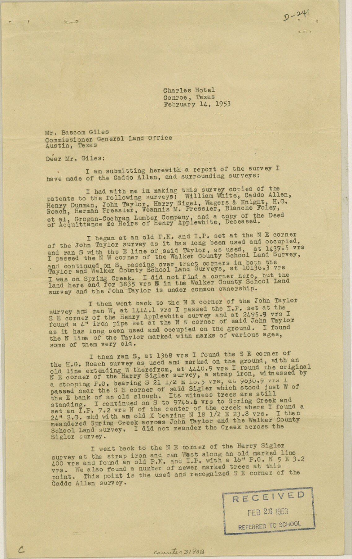
[Surveyor's report regarding the Caddo Allen survey and surrounding area in the south part of the county on Spring Creek]
-
Map/Doc
31908
-
Collection
General Map Collection
-
Object Dates
2/14/1953 (Creation Date)
2/26/1953 (File Date)
-
People and Organizations
R.B. Smitherman (Surveyor/Engineer)
-
Counties
Montgomery Harris
-
Subjects
Surveying Sketch File
-
Height x Width
14.1 x 8.9 inches
35.8 x 22.6 cm
-
Medium
paper, print
-
Comments
See Montgomery County Rolled Sketch 33 (9541).
-
Features
Spring Creek
Bedias Lake
Related maps
Montgomery County Rolled Sketch 33

Print $40.00
- Digital $50.00
Montgomery County Rolled Sketch 33
1953
Size 48.1 x 39.6 inches
Map/Doc 9541
Part of: General Map Collection
Crockett County Working Sketch 52

Print $20.00
- Digital $50.00
Crockett County Working Sketch 52
1941
Size 26.0 x 33.5 inches
Map/Doc 68385
Live Oak County Working Sketch 19

Print $20.00
- Digital $50.00
Live Oak County Working Sketch 19
1962
Size 27.4 x 34.5 inches
Map/Doc 70604
Map of Refugio

Print $20.00
- Digital $50.00
Map of Refugio
1851
Size 27.2 x 25.6 inches
Map/Doc 3989
Brewster County Working Sketch 18

Print $20.00
- Digital $50.00
Brewster County Working Sketch 18
1934
Size 35.9 x 37.8 inches
Map/Doc 67552
Harris County Sketch File AA3

Print $8.00
- Digital $50.00
Harris County Sketch File AA3
Size 8.2 x 8.5 inches
Map/Doc 25326
Hutchinson County Working Sketch 49

Print $20.00
- Digital $50.00
Hutchinson County Working Sketch 49
1988
Size 35.2 x 37.3 inches
Map/Doc 66409
East Part of Jeff Davis Co.

Print $20.00
- Digital $50.00
East Part of Jeff Davis Co.
1977
Size 46.4 x 35.7 inches
Map/Doc 73194
Webb County Working Sketch 85

Print $20.00
- Digital $50.00
Webb County Working Sketch 85
1981
Size 21.1 x 29.0 inches
Map/Doc 72452
Sabine River, Iron Bridge Crossing Sheet

Print $20.00
- Digital $50.00
Sabine River, Iron Bridge Crossing Sheet
1936
Size 33.0 x 40.6 inches
Map/Doc 65139
Tyler County Sketch File 19a

Print $4.00
- Digital $50.00
Tyler County Sketch File 19a
Size 8.1 x 14.1 inches
Map/Doc 38672
Polk County Sketch File 38

Print $20.00
- Digital $50.00
Polk County Sketch File 38
Size 13.9 x 8.8 inches
Map/Doc 34268
Swisher County Working Sketch 2

Print $20.00
- Digital $50.00
Swisher County Working Sketch 2
1950
Size 21.5 x 21.7 inches
Map/Doc 62413
You may also like
Edwards County Working Sketch 93

Print $20.00
- Digital $50.00
Edwards County Working Sketch 93
1966
Size 30.7 x 35.7 inches
Map/Doc 68969
Crockett County Sketch File 98

Print $8.00
- Digital $50.00
Crockett County Sketch File 98
1925
Size 12.5 x 8.9 inches
Map/Doc 19976
Liberty County Working Sketch 67

Print $20.00
- Digital $50.00
Liberty County Working Sketch 67
1971
Size 35.3 x 44.5 inches
Map/Doc 70527
San Saba County Working Sketch 10

Print $40.00
- Digital $50.00
San Saba County Working Sketch 10
1985
Size 33.4 x 52.9 inches
Map/Doc 63798
Andrews County Rolled Sketch 45

Print $40.00
- Digital $50.00
Andrews County Rolled Sketch 45
1946
Size 111.7 x 41.0 inches
Map/Doc 8402
Colorado County Working Sketch 29

Print $20.00
- Digital $50.00
Colorado County Working Sketch 29
1980
Size 15.4 x 12.4 inches
Map/Doc 68129
Flight Mission No. DAG-17K, Frame 143, Matagorda County

Print $20.00
- Digital $50.00
Flight Mission No. DAG-17K, Frame 143, Matagorda County
1952
Size 16.4 x 16.4 inches
Map/Doc 86360
Map of the Paluxy Artesian Reservoirs of the Black and Grand Prairies of Texas including the Eastern and Western Cross Timbers

Print $20.00
- Digital $50.00
Map of the Paluxy Artesian Reservoirs of the Black and Grand Prairies of Texas including the Eastern and Western Cross Timbers
1900
Size 24.8 x 24.4 inches
Map/Doc 75919
Freestone County Working Sketch 22

Print $20.00
- Digital $50.00
Freestone County Working Sketch 22
1981
Size 35.5 x 32.3 inches
Map/Doc 69264
Arizona Chemical Co. Brownfield Plant

Print $20.00
- Digital $50.00
Arizona Chemical Co. Brownfield Plant
Size 28.3 x 19.9 inches
Map/Doc 92892
Right of Way and Track Map Houston & Texas Central R.R. operated by the T. and N. O. R.R. Co., Fort Worth Branch

Print $40.00
- Digital $50.00
Right of Way and Track Map Houston & Texas Central R.R. operated by the T. and N. O. R.R. Co., Fort Worth Branch
1918
Size 31.1 x 57.4 inches
Map/Doc 64540
Flight Mission No. BRA-9M, Frame 63, Jefferson County

Print $20.00
- Digital $50.00
Flight Mission No. BRA-9M, Frame 63, Jefferson County
1953
Size 18.6 x 22.4 inches
Map/Doc 85646