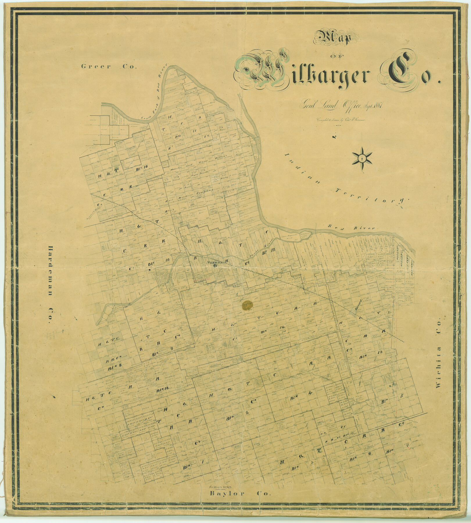
Map of Wilbarger County
-
Map/Doc
16926
-
Collection
General Map Collection
-
Object Dates
1887 (Creation Date)
-
People and Organizations
Texas General Land Office (Publisher)
Charles P. Scrivener (Draftsman)
Charles P. Scrivener (Compiler)
-
Counties
Wilbarger
-
Subjects
County
-
Height x Width
52.2 x 47.0 inches
132.6 x 119.4 cm
-
Comments
Help Save Texas History - Adopt Me!
-
Features
Boggy Creek
Paradise Creek
Red River
South Beaver Creek
South Minnie's Creek
Beaver Creek
Minnie's Creek
Camp Creek
Bluff Creek
Sunflower Creek
Rocky Creek
Jennie's Creek
Turkey Creek
South Fork of Red River
Ennis Creek
West China Creek
Pool Creek
Harrold
FW&DC
Vernon
Farmers Creek
Pease River
Wild Creek
Cottonwood Lake
Wanders Creek
Dirkins Springs
Part of: General Map Collection
Andrews County Rolled Sketch 32

Print $20.00
- Digital $50.00
Andrews County Rolled Sketch 32
1950
Size 26.2 x 16.4 inches
Map/Doc 77176
Terrell County Rolled Sketch 51B

Print $20.00
- Digital $50.00
Terrell County Rolled Sketch 51B
1957
Size 23.0 x 23.8 inches
Map/Doc 7969
El Paso County Boundary File 7

Print $14.00
- Digital $50.00
El Paso County Boundary File 7
Size 14.0 x 8.8 inches
Map/Doc 53087
Jefferson County Rolled Sketch 59

Print $40.00
- Digital $50.00
Jefferson County Rolled Sketch 59
1898
Size 30.0 x 59.4 inches
Map/Doc 9313
Amistad International Reservoir on Rio Grande 68a

Print $20.00
- Digital $50.00
Amistad International Reservoir on Rio Grande 68a
1949
Size 28.4 x 39.6 inches
Map/Doc 73354
Parker County Boundary File 1

Print $6.00
- Digital $50.00
Parker County Boundary File 1
Size 11.2 x 8.7 inches
Map/Doc 57833
Trinity River, Levee Improvements, District Widths of Floodways

Print $20.00
- Digital $50.00
Trinity River, Levee Improvements, District Widths of Floodways
1920
Size 25.0 x 18.6 inches
Map/Doc 65252
Presidio County Working Sketch 143

Print $20.00
- Digital $50.00
Presidio County Working Sketch 143
1990
Size 15.9 x 20.9 inches
Map/Doc 71821
Crockett County Rolled Sketch LO

Print $20.00
- Digital $50.00
Crockett County Rolled Sketch LO
Size 38.7 x 21.1 inches
Map/Doc 5638
Presidio de San Antonio de Bejar

Presidio de San Antonio de Bejar
2006
Size 10.8 x 16.9 inches
Map/Doc 87385
Coryell County Rolled Sketch 3

Print $20.00
- Digital $50.00
Coryell County Rolled Sketch 3
1974
Size 24.6 x 36.4 inches
Map/Doc 5567
Railroad Track Map, H&TCRRCo., Falls County, Texas

Print $4.00
- Digital $50.00
Railroad Track Map, H&TCRRCo., Falls County, Texas
1918
Size 11.5 x 18.6 inches
Map/Doc 62850
You may also like
Menard County Rolled Sketch 15

Print $20.00
- Digital $50.00
Menard County Rolled Sketch 15
1983
Size 27.9 x 22.0 inches
Map/Doc 6761
Hunt County Boundary File 10b

Print $4.00
- Digital $50.00
Hunt County Boundary File 10b
Size 11.3 x 8.9 inches
Map/Doc 55264
Right of Way and Track Map, International & Gt. Northern Ry. Operated by the International & Gt. Northern Ry. Co., Gulf Division

Print $40.00
- Digital $50.00
Right of Way and Track Map, International & Gt. Northern Ry. Operated by the International & Gt. Northern Ry. Co., Gulf Division
1917
Size 25.1 x 56.6 inches
Map/Doc 64252
Van Zandt County Sketch File 23

Print $4.00
- Digital $50.00
Van Zandt County Sketch File 23
1858
Size 6.8 x 8.2 inches
Map/Doc 39437
Dickens County Sketch File F1

Print $28.00
- Digital $50.00
Dickens County Sketch File F1
Size 11.4 x 8.7 inches
Map/Doc 20849
Sketch showing the Fred Turner surveys in Pecos County, Texas

Print $20.00
- Digital $50.00
Sketch showing the Fred Turner surveys in Pecos County, Texas
1928
Size 28.9 x 36.0 inches
Map/Doc 91590
Map of Alabama and Texas Cattle Co's Pasture

Print $20.00
- Digital $50.00
Map of Alabama and Texas Cattle Co's Pasture
Size 17.6 x 18.1 inches
Map/Doc 5064
Brewster County Rolled Sketch 73

Print $20.00
- Digital $50.00
Brewster County Rolled Sketch 73
1938
Size 19.7 x 23.3 inches
Map/Doc 5239
Lampasas County Working Sketch 1

Print $20.00
- Digital $50.00
Lampasas County Working Sketch 1
Size 16.2 x 20.3 inches
Map/Doc 70278
[Elizabeth Stanley, William H. Anderson, and surrounding surveys]
![91022, [Elizabeth Stanley, William H. Anderson, and surrounding surveys], Twichell Survey Records](https://historictexasmaps.com/wmedia_w700/maps/91022-1.tif.jpg)
Print $20.00
- Digital $50.00
[Elizabeth Stanley, William H. Anderson, and surrounding surveys]
Size 27.0 x 18.9 inches
Map/Doc 91022
Louisiana and Texas Intracoastal Waterway - Matagorda Bay to San Antonio Bay Dredging - Sheet 2

Print $20.00
- Digital $50.00
Louisiana and Texas Intracoastal Waterway - Matagorda Bay to San Antonio Bay Dredging - Sheet 2
1938
Size 31.0 x 41.2 inches
Map/Doc 61815
Brazoria County NRC Article 33.136 Sketch 17

Print $88.00
- Digital $50.00
Brazoria County NRC Article 33.136 Sketch 17
2015
Size 22.0 x 34.0 inches
Map/Doc 95020