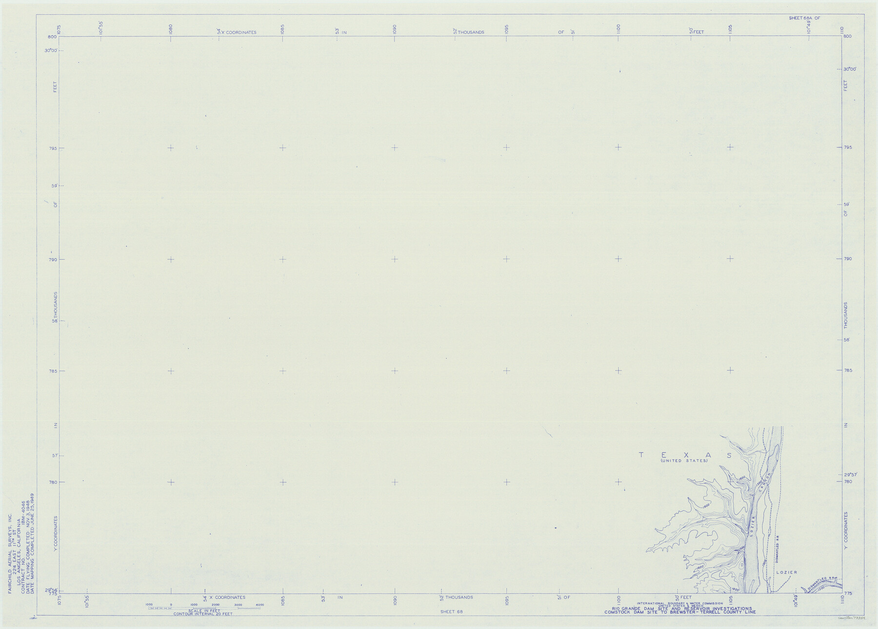
Amistad International Reservoir on Rio Grande 68a
Rio Grande Dam Site and Reservoir Investigations
-
Map/Doc
73354
-
Collection
General Map Collection
-
Object Dates
1949/6/25 (Creation Date)
-
People and Organizations
International Boundary and Water Commission (Publisher)
Fairchild Aerial Surveys Inc. (Surveyor/Engineer)
-
Counties
Terrell
-
Subjects
River Surveys Texas Boundaries Topographic
-
Height x Width
28.4 x 39.6 inches
72.1 x 100.6 cm
-
Medium
blueline
-
Comments
Comstock Dam site to Brewster-Terrell County line. Shows dismantled railroad bed by Lozier Canyon.
Part of: General Map Collection
Andrews County Rolled Sketch 42

Print $20.00
- Digital $50.00
Andrews County Rolled Sketch 42
Size 27.3 x 36.0 inches
Map/Doc 77182
Cass County Working Sketch 41

Print $20.00
- Digital $50.00
Cass County Working Sketch 41
1985
Size 34.0 x 42.7 inches
Map/Doc 67944
Anderson County Sketch File 11

Print $6.00
- Digital $50.00
Anderson County Sketch File 11
1853
Size 8.7 x 6.6 inches
Map/Doc 12765
[Sketch for Mineral Application 19560 - 19588 - San Bernard River]
![65580, [Sketch for Mineral Application 19560 - 19588 - San Bernard River], General Map Collection](https://historictexasmaps.com/wmedia_w700/maps/65580.tif.jpg)
Print $40.00
- Digital $50.00
[Sketch for Mineral Application 19560 - 19588 - San Bernard River]
1928
Size 98.2 x 33.1 inches
Map/Doc 65580
Jefferson County Rolled Sketch 57

Print $20.00
- Digital $50.00
Jefferson County Rolled Sketch 57
1883
Size 18.6 x 25.9 inches
Map/Doc 6409
Flight Mission No. DAG-17K, Frame 119, Matagorda County

Print $20.00
- Digital $50.00
Flight Mission No. DAG-17K, Frame 119, Matagorda County
1952
Size 16.4 x 16.5 inches
Map/Doc 86339
Flight Mission No. CLL-1N, Frame 107, Willacy County

Print $20.00
- Digital $50.00
Flight Mission No. CLL-1N, Frame 107, Willacy County
1954
Size 18.5 x 22.1 inches
Map/Doc 87041
Winkler County Working Sketch 6

Print $20.00
- Digital $50.00
Winkler County Working Sketch 6
1957
Size 34.5 x 31.5 inches
Map/Doc 72600
Brazoria County NRC Article 33.136 Sketch 28

Print $24.00
Brazoria County NRC Article 33.136 Sketch 28
2025
Map/Doc 97473
Pecos County Sketch File 63

Print $94.00
- Digital $50.00
Pecos County Sketch File 63
1919
Size 8.1 x 13.9 inches
Map/Doc 33792
Flight Mission No. BRA-16M, Frame 119, Jefferson County

Print $20.00
- Digital $50.00
Flight Mission No. BRA-16M, Frame 119, Jefferson County
1953
Size 18.6 x 22.5 inches
Map/Doc 85729
Duval County Working Sketch 44

Print $20.00
- Digital $50.00
Duval County Working Sketch 44
1977
Size 27.5 x 40.7 inches
Map/Doc 68768
You may also like
Gregg County Boundary File 2

Print $8.00
- Digital $50.00
Gregg County Boundary File 2
Size 8.8 x 3.7 inches
Map/Doc 53984
Knox County Sketch File 27

Print $20.00
- Digital $50.00
Knox County Sketch File 27
1963
Size 20.3 x 19.7 inches
Map/Doc 11964
Mitchell County Working Sketch 5

Print $40.00
- Digital $50.00
Mitchell County Working Sketch 5
1956
Size 60.4 x 28.2 inches
Map/Doc 71062
Val Verde County Working Sketch 95

Print $20.00
- Digital $50.00
Val Verde County Working Sketch 95
1980
Size 26.5 x 31.8 inches
Map/Doc 72230
Post Route Map of the State of Texas, Showing Post Offices with the Intermediate Distances on Mail Routes

Print $40.00
- Digital $50.00
Post Route Map of the State of Texas, Showing Post Offices with the Intermediate Distances on Mail Routes
1908
Size 52.5 x 35.1 inches
Map/Doc 3163
Fayette County Boundary File 2

Print $53.00
- Digital $50.00
Fayette County Boundary File 2
Size 11.2 x 9.0 inches
Map/Doc 53331
Fayette County Boundary File 7

Print $40.00
- Digital $50.00
Fayette County Boundary File 7
Size 18.1 x 13.1 inches
Map/Doc 53400
Hockley County Sketch File 13

Print $4.00
- Digital $50.00
Hockley County Sketch File 13
1914
Size 8.9 x 10.9 inches
Map/Doc 26548
Hutchinson County Rolled Sketch 43

Print $40.00
- Digital $50.00
Hutchinson County Rolled Sketch 43
1992
Size 40.4 x 49.4 inches
Map/Doc 6313
Presidio County Working Sketch 86

Print $20.00
- Digital $50.00
Presidio County Working Sketch 86
1971
Size 45.4 x 42.2 inches
Map/Doc 71763
Liberty County Working Sketch Graphic Index - east part

Print $20.00
- Digital $50.00
Liberty County Working Sketch Graphic Index - east part
1977
Size 46.0 x 34.5 inches
Map/Doc 76620
General Highway Map, Grimes County, Texas

Print $20.00
General Highway Map, Grimes County, Texas
1940
Size 25.0 x 18.4 inches
Map/Doc 79106