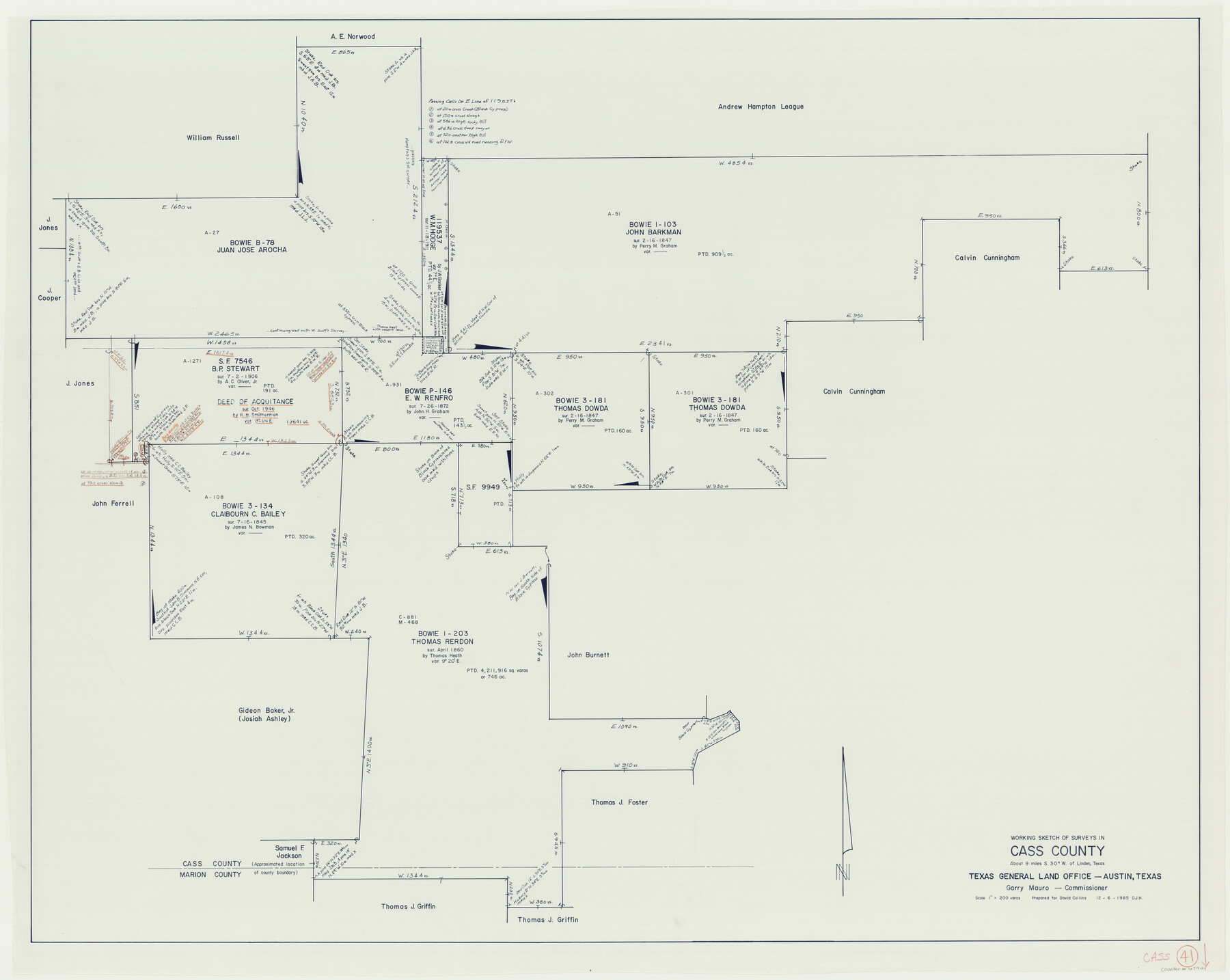
Cass County Working Sketch 41
-
Map/Doc
67944
-
Collection
General Map Collection
-
Object Dates
12/6/1985 (Creation Date)
-
People and Organizations
Douglas Howard (Draftsman)
-
Counties
Cass
-
Subjects
Surveying Working Sketch
-
Height x Width
34.0 x 42.7 inches
86.4 x 108.5 cm
-
Scale
1" = 200 varas
Part of: General Map Collection
Tarrant County Sketch File 35

Print $50.00
Tarrant County Sketch File 35
2018
Size 11.0 x 8.5 inches
Map/Doc 95394
Gregg County Sketch File 3

Print $6.00
- Digital $50.00
Gregg County Sketch File 3
1931
Size 11.2 x 8.7 inches
Map/Doc 24569
Childress County Sketch File 17

Print $8.00
- Digital $50.00
Childress County Sketch File 17
Size 13.0 x 8.2 inches
Map/Doc 18286
Flight Mission No. BRA-8M, Frame 80, Jefferson County

Print $20.00
- Digital $50.00
Flight Mission No. BRA-8M, Frame 80, Jefferson County
1953
Size 15.9 x 15.6 inches
Map/Doc 85600
Map of Harris County

Print $20.00
- Digital $50.00
Map of Harris County
1893
Size 26.9 x 36.5 inches
Map/Doc 66855
Sutton County Working Sketch 18

Print $20.00
- Digital $50.00
Sutton County Working Sketch 18
1978
Size 39.9 x 31.5 inches
Map/Doc 62361
Anderson County Working Sketch Graphic Index

Print $40.00
- Digital $50.00
Anderson County Working Sketch Graphic Index
1942
Size 52.0 x 48.3 inches
Map/Doc 76452
Burleson County Working Sketch 16

Print $3.00
- Digital $50.00
Burleson County Working Sketch 16
1980
Size 10.1 x 14.1 inches
Map/Doc 67735
Duval County Working Sketch 45

Print $20.00
- Digital $50.00
Duval County Working Sketch 45
1979
Size 29.7 x 30.8 inches
Map/Doc 68769
Harris County NRC Article 33.136 Location Key Sheet

Print $20.00
- Digital $50.00
Harris County NRC Article 33.136 Location Key Sheet
1995
Size 27.0 x 21.8 inches
Map/Doc 82992
[Cotton Belt, St. Louis Southwestern Railway of Texas, Alignment through Smith County]
![64381, [Cotton Belt, St. Louis Southwestern Railway of Texas, Alignment through Smith County], General Map Collection](https://historictexasmaps.com/wmedia_w700/maps/64381.tif.jpg)
Print $20.00
- Digital $50.00
[Cotton Belt, St. Louis Southwestern Railway of Texas, Alignment through Smith County]
1903
Size 21.3 x 29.4 inches
Map/Doc 64381
Pecos County Rolled Sketch 190

Print $20.00
- Digital $50.00
Pecos County Rolled Sketch 190
2005
Size 20.3 x 26.1 inches
Map/Doc 83284
You may also like
Galveston County Rolled Sketch WF

Print $20.00
- Digital $50.00
Galveston County Rolled Sketch WF
Size 25.2 x 34.1 inches
Map/Doc 5991
[H. & T. C. Block 47, Sections 47- 55 Corrections]
![91529, [H. & T. C. Block 47, Sections 47- 55 Corrections], Twichell Survey Records](https://historictexasmaps.com/wmedia_w700/maps/91529-1.tif.jpg)
Print $3.00
- Digital $50.00
[H. & T. C. Block 47, Sections 47- 55 Corrections]
Size 11.6 x 13.3 inches
Map/Doc 91529
Tom Green County Working Sketch 11

Print $20.00
- Digital $50.00
Tom Green County Working Sketch 11
1968
Size 33.9 x 39.2 inches
Map/Doc 69380
The Coast & Bays of Western Texas, St. Joseph's and Mustang Islands from actual survey, the remainder from county maps, etc.

Print $20.00
- Digital $50.00
The Coast & Bays of Western Texas, St. Joseph's and Mustang Islands from actual survey, the remainder from county maps, etc.
1857
Size 27.9 x 18.3 inches
Map/Doc 72766
Hutchinson County Working Sketch 41

Print $20.00
- Digital $50.00
Hutchinson County Working Sketch 41
1978
Size 26.8 x 22.3 inches
Map/Doc 66401

Coast Chart No. 210 Aransas Pass and Corpus Christi Bay with the coast to latitude 27° 12' Texas

Print $20.00
- Digital $50.00
Coast Chart No. 210 Aransas Pass and Corpus Christi Bay with the coast to latitude 27° 12' Texas
1887
Size 27.1 x 18.5 inches
Map/Doc 72788
Tom Green County Sketch File 79A

Print $4.00
- Digital $50.00
Tom Green County Sketch File 79A
1970
Size 14.5 x 8.8 inches
Map/Doc 38258
Flight Mission No. CRK-7P, Frame 25, Refugio County

Print $20.00
- Digital $50.00
Flight Mission No. CRK-7P, Frame 25, Refugio County
1956
Size 18.6 x 22.3 inches
Map/Doc 86945
The First Part of Captn. Pike's Chart of the Internal Part of Louisiana

Print $20.00
- Digital $50.00
The First Part of Captn. Pike's Chart of the Internal Part of Louisiana
1810
Size 19.6 x 21.2 inches
Map/Doc 95154

Van Zandt County Sketch File 31

Print $4.00
- Digital $50.00
Van Zandt County Sketch File 31
1860
Size 12.6 x 8.1 inches
Map/Doc 39463