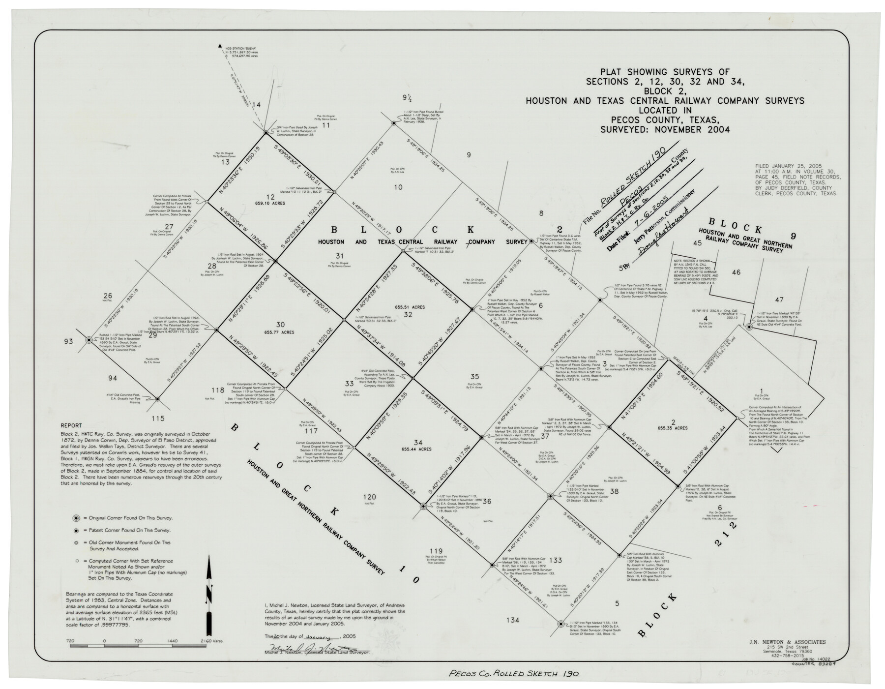
Pecos County Rolled Sketch 190
Plat showing surveys of sections 2, 12, 30, 32, and 34, Block 2, Houston and Texas Central Railway Company surveys located in Pecos County, Texas
-
Map/Doc
83284
-
Collection
General Map Collection
-
Object Dates
1/20/2005 (Creation Date)
7/6/2005 (File Date)
11/2004 (Survey Date)
-
People and Organizations
Michel J. Newton (Surveyor/Engineer)
-
Counties
Pecos
-
Subjects
Surveying Rolled Sketch
-
Height x Width
20.3 x 26.1 inches
51.6 x 66.3 cm
-
Medium
mylar, print
Part of: General Map Collection
San Jacinto County Working Sketch 22

Print $20.00
- Digital $50.00
San Jacinto County Working Sketch 22
1940
Size 21.3 x 25.3 inches
Map/Doc 63735
Fort Bend County State Real Property Sketch 14

Print $40.00
- Digital $50.00
Fort Bend County State Real Property Sketch 14
1985
Size 36.7 x 35.6 inches
Map/Doc 61688
Hardeman County

Print $20.00
- Digital $50.00
Hardeman County
1876
Size 24.1 x 31.5 inches
Map/Doc 3625
Map of the River Sabine from Logan's Ferry to 32nd degree of north latitude

Print $3.00
- Digital $50.00
Map of the River Sabine from Logan's Ferry to 32nd degree of north latitude
1841
Size 8.7 x 11.1 inches
Map/Doc 94497
Flight Mission No. DQN-7K, Frame 94, Calhoun County

Print $20.00
- Digital $50.00
Flight Mission No. DQN-7K, Frame 94, Calhoun County
1953
Size 18.6 x 22.1 inches
Map/Doc 84485
Young County Sketch File 6

Print $14.00
- Digital $50.00
Young County Sketch File 6
Size 13.0 x 8.2 inches
Map/Doc 40852
San Augustine County Working Sketch 23

Print $20.00
- Digital $50.00
San Augustine County Working Sketch 23
1974
Size 23.6 x 36.4 inches
Map/Doc 63711
Loving County Rolled Sketch 19

Print $20.00
- Digital $50.00
Loving County Rolled Sketch 19
2020
Size 24.4 x 35.3 inches
Map/Doc 96575
National Map Company's Map of Texas showing counties, cities, towns, villages and post offices, steam and electric railways with stations and distance between stations

Print $40.00
- Digital $50.00
National Map Company's Map of Texas showing counties, cities, towns, villages and post offices, steam and electric railways with stations and distance between stations
1920
Size 50.3 x 51.1 inches
Map/Doc 10749
[Map of Block 97, Borden and Scurry Co (Exhibit A); Map of Southeastern part of Young Territory; Map of part of of Borden, Fisher, Kent, Mitchell, Scurry and Garza Cos. Showing the north boundary line of the T&P 80 mile reservation]
![65693, [Map of Block 97, Borden and Scurry Co (Exhibit A); Map of Southeastern part of Young Territory; Map of part of of Borden, Fisher, Kent, Mitchell, Scurry and Garza Cos. Showing the north boundary line of the T&P 80 mile reservation], General Map Collection](https://historictexasmaps.com/wmedia_w700/maps/65693.tif.jpg)
Print $20.00
- Digital $50.00
[Map of Block 97, Borden and Scurry Co (Exhibit A); Map of Southeastern part of Young Territory; Map of part of of Borden, Fisher, Kent, Mitchell, Scurry and Garza Cos. Showing the north boundary line of the T&P 80 mile reservation]
1901
Size 31.2 x 23.3 inches
Map/Doc 65693
Flight Mission No. CRE-1R, Frame 194, Jackson County

Print $20.00
- Digital $50.00
Flight Mission No. CRE-1R, Frame 194, Jackson County
1956
Size 18.5 x 22.3 inches
Map/Doc 85348
Real County Sketch File 13

Print $20.00
- Digital $50.00
Real County Sketch File 13
Size 23.2 x 17.9 inches
Map/Doc 12232
You may also like
General Highway Map, Houston County, Texas

Print $20.00
General Highway Map, Houston County, Texas
1940
Size 25.0 x 18.6 inches
Map/Doc 79132
Kenedy County Aerial Photograph Index Sheet 9

Print $20.00
- Digital $50.00
Kenedy County Aerial Photograph Index Sheet 9
1943
Size 23.6 x 18.5 inches
Map/Doc 83717
Sterling County Sketch File 13

Print $20.00
- Digital $50.00
Sterling County Sketch File 13
Size 26.1 x 19.4 inches
Map/Doc 12359
Karnes County Working Sketch 3

Print $20.00
- Digital $50.00
Karnes County Working Sketch 3
1943
Size 34.6 x 31.4 inches
Map/Doc 66651
Rio Grande, Santa Rosa Sheet

Print $20.00
- Digital $50.00
Rio Grande, Santa Rosa Sheet
1937
Size 37.3 x 37.3 inches
Map/Doc 65116
Orange County Working Sketch 5

Print $20.00
- Digital $50.00
Orange County Working Sketch 5
1917
Size 12.6 x 20.6 inches
Map/Doc 71337
Tom Green County Rolled Sketch 14

Print $20.00
- Digital $50.00
Tom Green County Rolled Sketch 14
1953
Size 28.3 x 30.9 inches
Map/Doc 7999
[Pencil sketch showing area between sections 1102, 1101, 1111, and 1112 on the west and sections 3-6 on the east]
![90365, [Pencil sketch showing area between sections 1102, 1101, 1111, and 1112 on the west and sections 3-6 on the east], Twichell Survey Records](https://historictexasmaps.com/wmedia_w700/maps/90365-1.tif.jpg)
Print $2.00
- Digital $50.00
[Pencil sketch showing area between sections 1102, 1101, 1111, and 1112 on the west and sections 3-6 on the east]
Size 5.1 x 8.1 inches
Map/Doc 90365
North Line of Stonewall County, South Line of King County

Print $20.00
- Digital $50.00
North Line of Stonewall County, South Line of King County
1895
Size 8.0 x 41.1 inches
Map/Doc 91058

Chambers County Working Sketch 7

Print $20.00
- Digital $50.00
Chambers County Working Sketch 7
1939
Size 30.6 x 39.6 inches
Map/Doc 67990
[North/South line through middle of Block K5]
![90600, [North/South line through middle of Block K5], Twichell Survey Records](https://historictexasmaps.com/wmedia_w700/maps/90600-1.tif.jpg)
Print $3.00
- Digital $50.00
[North/South line through middle of Block K5]
Size 6.8 x 16.9 inches
Map/Doc 90600