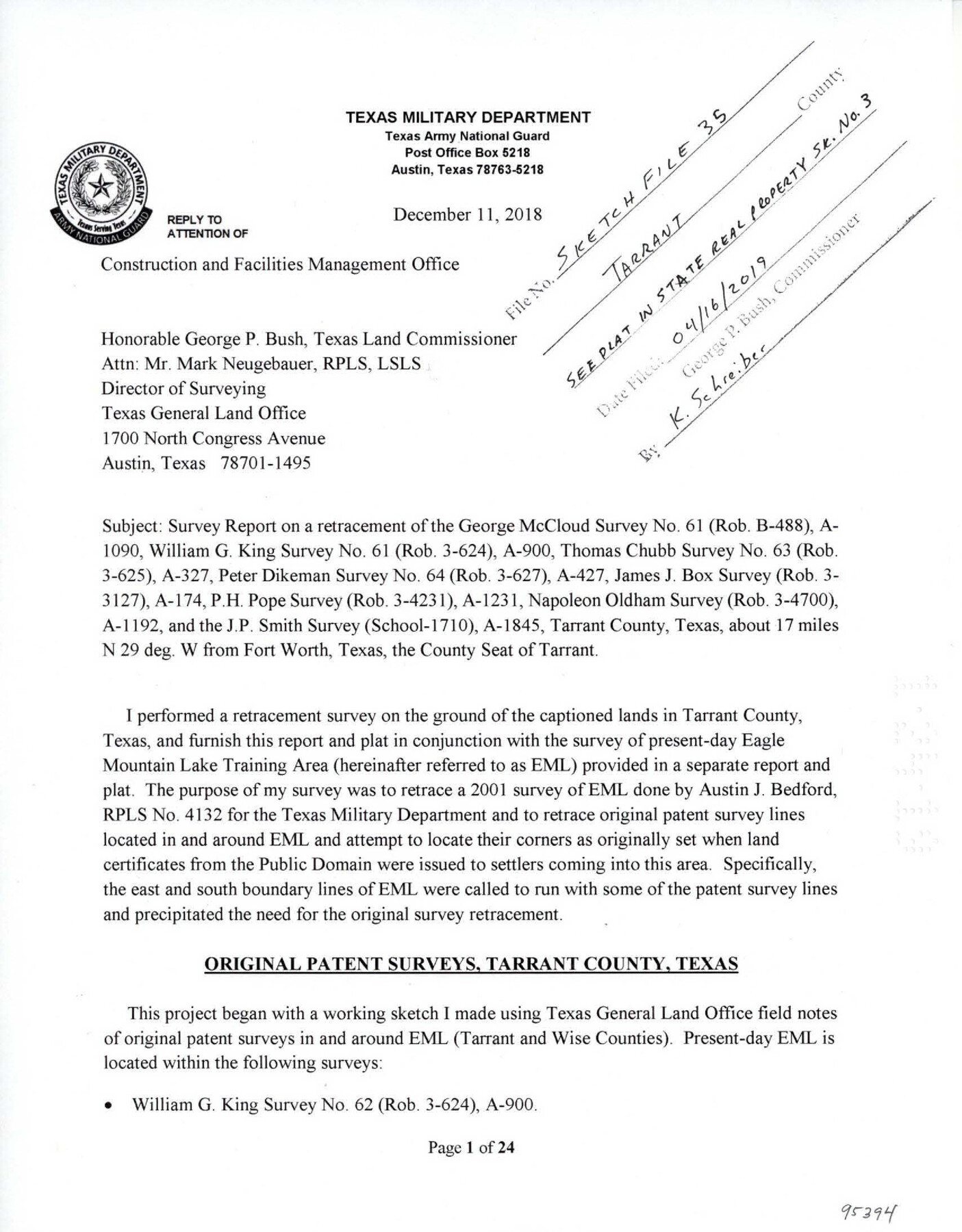
Tarrant County Sketch File 35
Survey report on a retracement of A-1090 (McCloud), A-900 (King), A-327 (Chubb), A-427 (Dikeman), A-174 (Box), A-1231 (Pope), A-1192 (Oldham), and A-1845 (Smith)
-
Map/Doc
95394
-
Collection
General Map Collection
-
Object Dates
12/11/2018 (Creation Date)
4/16/2019 (File Date)
-
People and Organizations
David A. Rolbiecki (Surveyor/Engineer)
-
Counties
Tarrant
-
Subjects
Surveying Sketch File
-
Height x Width
11.0 x 8.5 inches
27.9 x 21.6 cm
-
Medium
paper, print
-
Comments
See Tarrant County State Real Property Sketch 3 (95402) for plat
Related maps
Tarrant County State Real Property Sketch 3

Print $20.00
- Digital $50.00
Tarrant County State Real Property Sketch 3
2018
Size 35.1 x 23.8 inches
Map/Doc 95402
Part of: General Map Collection
San Saba County Sketch File 5

Print $4.00
- Digital $50.00
San Saba County Sketch File 5
Size 12.8 x 8.0 inches
Map/Doc 36412
Map of Cherokee County

Print $20.00
- Digital $50.00
Map of Cherokee County
1851
Size 24.6 x 18.3 inches
Map/Doc 3386
Flight Mission No. BQY-4M, Frame 37, Harris County

Print $20.00
- Digital $50.00
Flight Mission No. BQY-4M, Frame 37, Harris County
1953
Size 18.6 x 22.3 inches
Map/Doc 85252
Tarrant County Boundary File 3

Print $30.00
- Digital $50.00
Tarrant County Boundary File 3
Size 11.4 x 8.8 inches
Map/Doc 59136
Nueces County Rolled Sketch 113A

Print $20.00
- Digital $50.00
Nueces County Rolled Sketch 113A
1972
Size 19.1 x 24.4 inches
Map/Doc 7121
Castro County Working Sketch 4

Print $20.00
- Digital $50.00
Castro County Working Sketch 4
1920
Size 17.0 x 16.2 inches
Map/Doc 67899
Jack County Sketch File 7

Print $6.00
- Digital $50.00
Jack County Sketch File 7
1857
Size 6.7 x 12.4 inches
Map/Doc 27516
Map of Hale County

Print $20.00
- Digital $50.00
Map of Hale County
1900
Size 47.8 x 38.6 inches
Map/Doc 66847
University Lands Hudspeth County, Texas, Blocks A to N

Print $40.00
- Digital $50.00
University Lands Hudspeth County, Texas, Blocks A to N
1935
Size 38.6 x 55.4 inches
Map/Doc 2447
Coast Chart No. 210 Aransas Pass and Corpus Christi Bay with the coast to latitude 27° 12' Texas

Print $20.00
- Digital $50.00
Coast Chart No. 210 Aransas Pass and Corpus Christi Bay with the coast to latitude 27° 12' Texas
1913
Size 26.8 x 18.2 inches
Map/Doc 72808
Sherman County

Print $20.00
- Digital $50.00
Sherman County
1932
Size 38.7 x 36.3 inches
Map/Doc 73289
Cooke County Working Sketch 30

Print $20.00
- Digital $50.00
Cooke County Working Sketch 30
1979
Size 26.6 x 28.4 inches
Map/Doc 68267
You may also like
General Highway Map, Karnes County, Texas

Print $20.00
General Highway Map, Karnes County, Texas
1961
Size 18.1 x 24.6 inches
Map/Doc 79547
Crockett County Sketch File 26

Print $58.00
- Digital $50.00
Crockett County Sketch File 26
1880
Size 8.7 x 7.2 inches
Map/Doc 19706
Uvalde County Sketch File 19

Print $4.00
- Digital $50.00
Uvalde County Sketch File 19
1882
Size 10.6 x 8.6 inches
Map/Doc 39000
Pecos County Rolled Sketch 41

Print $20.00
- Digital $50.00
Pecos County Rolled Sketch 41
Size 22.7 x 31.3 inches
Map/Doc 7219
[Surveys along the San Marcos River]
![152, [Surveys along the San Marcos River], General Map Collection](https://historictexasmaps.com/wmedia_w700/maps/152.tif.jpg)
Print $2.00
- Digital $50.00
[Surveys along the San Marcos River]
Size 9.6 x 8.0 inches
Map/Doc 152

Ft. W. & R. G. Ry. Right of Way Map, Chapin to Bluffdale, Hood County, Texas

Print $40.00
- Digital $50.00
Ft. W. & R. G. Ry. Right of Way Map, Chapin to Bluffdale, Hood County, Texas
1918
Size 37.3 x 120.2 inches
Map/Doc 64642
Bee County Sketch File 32

Print $4.00
- Digital $50.00
Bee County Sketch File 32
Size 7.9 x 12.6 inches
Map/Doc 14347
Real County Sketch File 12

Print $20.00
- Digital $50.00
Real County Sketch File 12
1932
Size 13.9 x 19.2 inches
Map/Doc 12231
Sutton County Rolled Sketch 66

Print $20.00
- Digital $50.00
Sutton County Rolled Sketch 66
Size 25.3 x 25.1 inches
Map/Doc 7901
Clay County Rolled Sketch 2

Print $20.00
- Digital $50.00
Clay County Rolled Sketch 2
1940
Size 35.9 x 26.8 inches
Map/Doc 5485
Travis County Rolled Sketch 7

Print $20.00
- Digital $50.00
Travis County Rolled Sketch 7
Size 17.4 x 37.0 inches
Map/Doc 8012