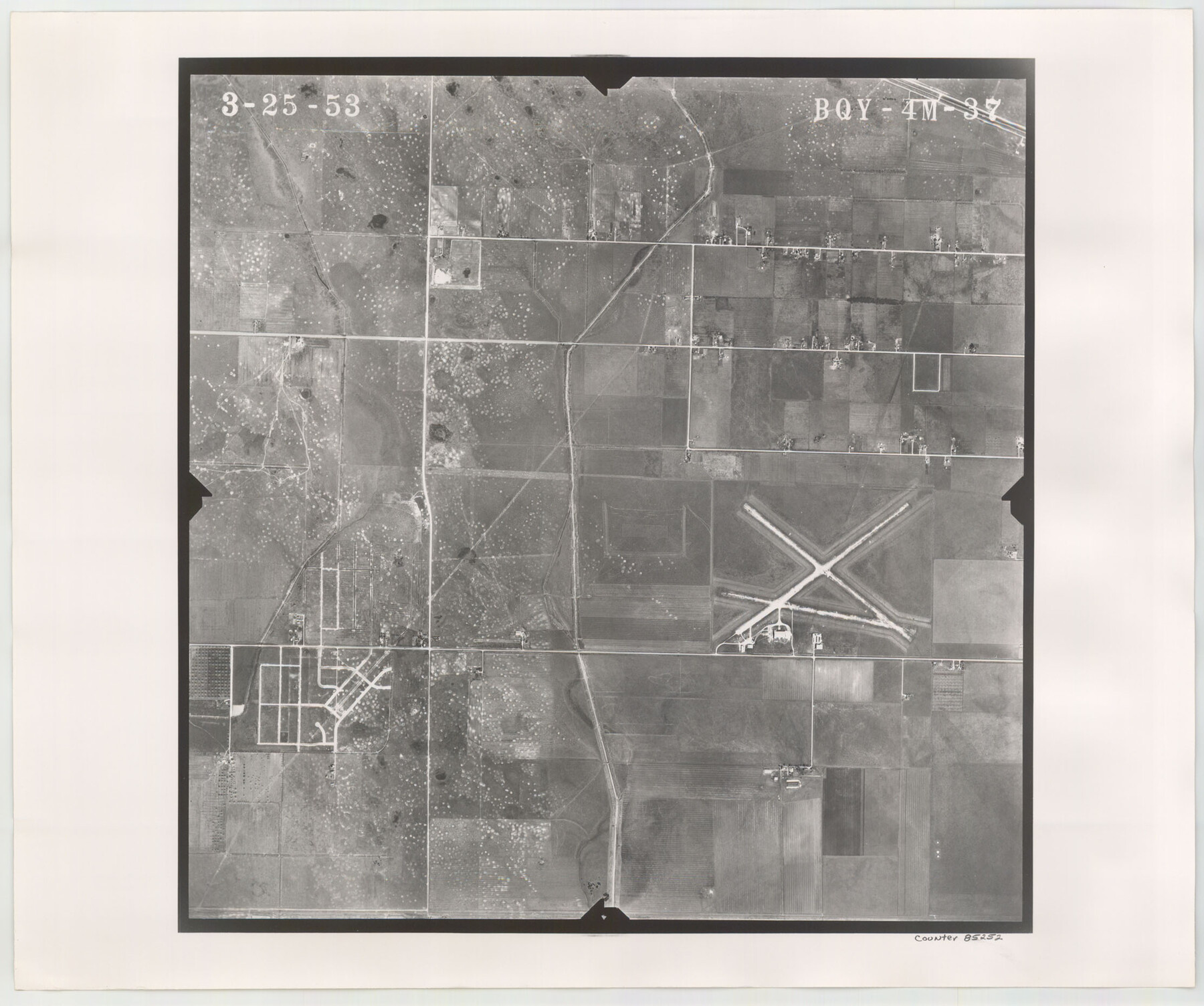
Flight Mission No. BQY-4M, Frame 37, Harris County
BQY-4M-37
-
Map/Doc
85252
-
Collection
General Map Collection
-
Object Dates
1953/3/25 (Creation Date)
-
People and Organizations
U. S. Department of Agriculture (Publisher)
-
Counties
Harris
-
Subjects
Aerial Photograph
-
Height x Width
18.6 x 22.3 inches
47.2 x 56.6 cm
-
Comments
Flown by Jack Ammann Photogrammetric Engineers of San Antonio, Texas.
Part of: General Map Collection
Archer County Sketch File 20

Print $6.00
- Digital $50.00
Archer County Sketch File 20
1936
Size 11.0 x 8.7 inches
Map/Doc 13655
San Patricio County Rolled Sketch 21

Print $20.00
- Digital $50.00
San Patricio County Rolled Sketch 21
1935
Size 25.9 x 24.7 inches
Map/Doc 7580
Flight Mission No. DCL-6C, Frame 19, Kenedy County

Print $20.00
- Digital $50.00
Flight Mission No. DCL-6C, Frame 19, Kenedy County
1943
Size 18.6 x 22.4 inches
Map/Doc 85876
Cameron County

Print $20.00
- Digital $50.00
Cameron County
1976
Size 31.0 x 38.3 inches
Map/Doc 95447
Callahan County Sketch File 17

Print $18.00
- Digital $50.00
Callahan County Sketch File 17
Size 11.0 x 8.5 inches
Map/Doc 93444
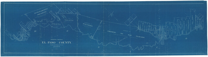
El Paso County Working Sketch 1
Print $40.00
- Digital $50.00
El Paso County Working Sketch 1
1911
Size 25.4 x 90.6 inches
Map/Doc 69022
Baylor County Sketch File A4

Print $8.00
- Digital $50.00
Baylor County Sketch File A4
Size 14.0 x 8.7 inches
Map/Doc 14084
Flight Mission No. BRA-16M, Frame 151, Jefferson County

Print $20.00
- Digital $50.00
Flight Mission No. BRA-16M, Frame 151, Jefferson County
1953
Size 18.7 x 22.3 inches
Map/Doc 85757
Goliad County Working Sketch 8

Print $20.00
- Digital $50.00
Goliad County Working Sketch 8
1937
Size 29.7 x 36.0 inches
Map/Doc 63198
Travis County Sketch File 50

Print $20.00
- Digital $50.00
Travis County Sketch File 50
1871
Size 18.7 x 23.5 inches
Map/Doc 12469
Flight Mission No. DQN-6K, Frame 69, Calhoun County

Print $20.00
- Digital $50.00
Flight Mission No. DQN-6K, Frame 69, Calhoun County
1953
Size 18.6 x 22.1 inches
Map/Doc 84441
Flight Mission No. BRA-7M, Frame 144, Jefferson County

Print $20.00
- Digital $50.00
Flight Mission No. BRA-7M, Frame 144, Jefferson County
1953
Size 18.5 x 22.3 inches
Map/Doc 85538
You may also like
Map Showing Lands Surveyed by Sylvan Sanders, Block D

Print $20.00
- Digital $50.00
Map Showing Lands Surveyed by Sylvan Sanders, Block D
Size 28.9 x 24.2 inches
Map/Doc 92441
Flight Mission No. DIX-7P, Frame 89, Aransas County

Print $20.00
- Digital $50.00
Flight Mission No. DIX-7P, Frame 89, Aransas County
1956
Size 18.7 x 22.4 inches
Map/Doc 83883
Callahan County Sketch File 3

Print $40.00
- Digital $50.00
Callahan County Sketch File 3
1860
Size 17.4 x 13.8 inches
Map/Doc 35857
Victoria County Working Sketch Graphic Index

Print $20.00
- Digital $50.00
Victoria County Working Sketch Graphic Index
1921
Size 47.0 x 39.0 inches
Map/Doc 76728
Austin County Sketch File 18

Print $14.00
- Digital $50.00
Austin County Sketch File 18
Size 12.8 x 8.2 inches
Map/Doc 13927
Upton County Rolled Sketch 49-CF

Print $20.00
- Digital $50.00
Upton County Rolled Sketch 49-CF
1926
Size 44.9 x 32.4 inches
Map/Doc 76143
Schleicher County Rolled Sketch 7

Print $20.00
- Digital $50.00
Schleicher County Rolled Sketch 7
Size 32.5 x 37.9 inches
Map/Doc 9904
Map of North America engraved to illustrate Mitchell's school and family geography

Print $20.00
- Digital $50.00
Map of North America engraved to illustrate Mitchell's school and family geography
1839
Size 11.8 x 9.5 inches
Map/Doc 93493
Menard County Working Sketch 9

Print $20.00
- Digital $50.00
Menard County Working Sketch 9
1937
Size 22.9 x 22.5 inches
Map/Doc 70956
Liberty County Sketch File 16

Print $4.00
- Digital $50.00
Liberty County Sketch File 16
1859
Size 11.4 x 6.7 inches
Map/Doc 29917
Anderson County Working Sketch 19

Print $20.00
- Digital $50.00
Anderson County Working Sketch 19
1951
Size 15.5 x 29.2 inches
Map/Doc 67019
[Central Part of Hockley County]
![91192, [Central Part of Hockley County], Twichell Survey Records](https://historictexasmaps.com/wmedia_w700/maps/91192-1.tif.jpg)
Print $20.00
- Digital $50.00
[Central Part of Hockley County]
Size 34.6 x 21.0 inches
Map/Doc 91192