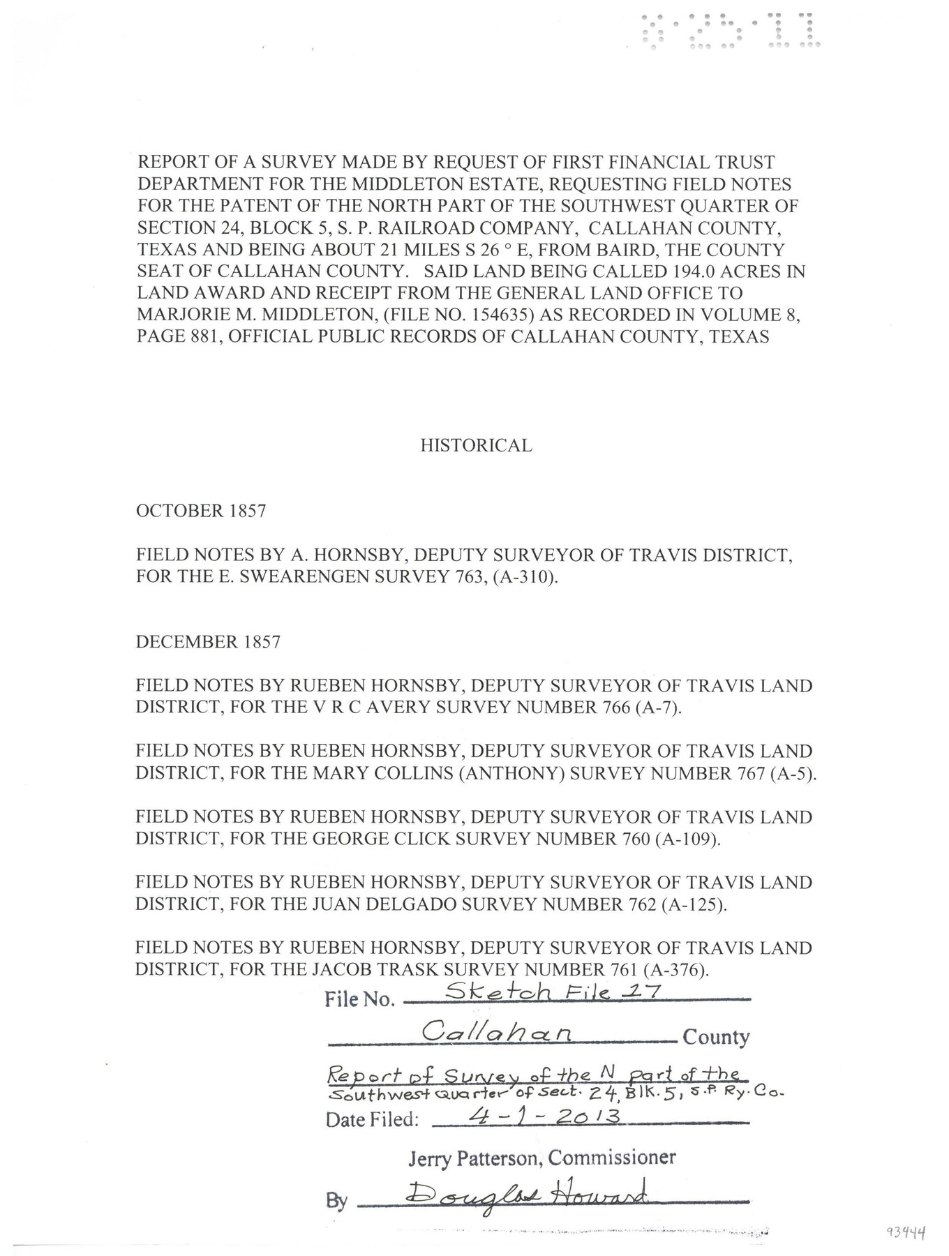
Callahan County Sketch File 17
Report of a survey made by request of First Financial Trust department for the Middleton Estate, requesting field notes for the patent of the north part of the southwest quarter of section 24, Block 5, S. P. RR. Co.
-
Map/Doc
93444
-
Collection
General Map Collection
-
Object Dates
2013/4/1 (File Date)
2010 (Survey Date)
-
People and Organizations
Maxey Sheppard (Surveyor/Engineer)
-
Counties
Callahan
-
Subjects
Surveying Sketch File
-
Height x Width
11.0 x 8.5 inches
27.9 x 21.6 cm
-
Medium
paper, print
-
Comments
See Callahan County Rolled Sketch 26 (93453) for plat.
Related maps
Callahan County Rolled Sketch 26

Print $20.00
- Digital $50.00
Callahan County Rolled Sketch 26
2010
Size 30.6 x 24.6 inches
Map/Doc 93453
Part of: General Map Collection
Intracoastal Waterway in Texas - Corpus Christi to Point Isabel including Arroyo Colorado to Mo. Pac. R.R. Bridge Near Harlingen

Print $20.00
- Digital $50.00
Intracoastal Waterway in Texas - Corpus Christi to Point Isabel including Arroyo Colorado to Mo. Pac. R.R. Bridge Near Harlingen
1933
Size 27.8 x 40.9 inches
Map/Doc 61864
Map Shelby County

Print $20.00
- Digital $50.00
Map Shelby County
1852
Size 20.1 x 31.5 inches
Map/Doc 4029
Knox County Rolled Sketch 26

Print $20.00
- Digital $50.00
Knox County Rolled Sketch 26
2007
Size 36.8 x 24.7 inches
Map/Doc 88822
Map of Cherokee County

Print $20.00
- Digital $50.00
Map of Cherokee County
1863
Size 25.5 x 17.7 inches
Map/Doc 3387
Jefferson County Sketch File 2

Print $50.00
- Digital $50.00
Jefferson County Sketch File 2
Size 11.2 x 8.8 inches
Map/Doc 28090
Brazoria County Rolled Sketch 50

Print $20.00
- Digital $50.00
Brazoria County Rolled Sketch 50
1914
Size 18.4 x 26.4 inches
Map/Doc 5187
Liberty County Sketch File 64

Print $4.00
- Digital $50.00
Liberty County Sketch File 64
1873
Size 9.9 x 7.9 inches
Map/Doc 30126
Grayson County Working Sketch 23

Print $20.00
- Digital $50.00
Grayson County Working Sketch 23
1976
Size 18.6 x 24.3 inches
Map/Doc 63262

Texas Gulf Coast Map from the Sabine River to the Rio Grande as subdivided for mineral development

Print $40.00
- Digital $50.00
Texas Gulf Coast Map from the Sabine River to the Rio Grande as subdivided for mineral development
1948
Size 49.2 x 73.7 inches
Map/Doc 2905
Travis County

Print $40.00
- Digital $50.00
Travis County
1963
Size 37.7 x 50.7 inches
Map/Doc 73597
Marion County Sketch File 14

Print $20.00
- Digital $50.00
Marion County Sketch File 14
Size 26.6 x 17.1 inches
Map/Doc 12024
You may also like
Armstrong County, State of Texas

Print $20.00
- Digital $50.00
Armstrong County, State of Texas
1888
Size 22.6 x 18.2 inches
Map/Doc 3245
Stonewall County Working Sketch 7

Print $20.00
- Digital $50.00
Stonewall County Working Sketch 7
1949
Size 30.7 x 24.5 inches
Map/Doc 62314
[Sections 6 and 7, Block 12, H. & G. N.]
![91584, [Sections 6 and 7, Block 12, H. & G. N.], Twichell Survey Records](https://historictexasmaps.com/wmedia_w700/maps/91584-1.tif.jpg)
Print $2.00
- Digital $50.00
[Sections 6 and 7, Block 12, H. & G. N.]
Size 12.4 x 9.2 inches
Map/Doc 91584

Brewster County Rolled Sketch 114

Print $20.00
- Digital $50.00
Brewster County Rolled Sketch 114
1964
Size 11.6 x 18.5 inches
Map/Doc 5275
Packery Channel

Print $20.00
- Digital $50.00
Packery Channel
1950
Size 17.6 x 17.5 inches
Map/Doc 2997
Colorado County Rolled Sketch 6

Print $20.00
- Digital $50.00
Colorado County Rolled Sketch 6
1976
Size 12.9 x 20.3 inches
Map/Doc 5533
Carson County Working Sketch Graphic Index

Print $20.00
- Digital $50.00
Carson County Working Sketch Graphic Index
1932
Size 41.3 x 37.9 inches
Map/Doc 76488
Motley County Sketch File 12 (N)

Print $3.00
- Digital $50.00
Motley County Sketch File 12 (N)
Size 20.0 x 18.4 inches
Map/Doc 42141
Map of Cooke County

Print $20.00
- Digital $50.00
Map of Cooke County
1857
Size 34.1 x 37.9 inches
Map/Doc 1973
Lynn County Rolled Sketch A

Print $20.00
- Digital $50.00
Lynn County Rolled Sketch A
1901
Size 33.5 x 34.2 inches
Map/Doc 9471
Flight Mission No. BQR-9K, Frame 9, Brazoria County

Print $20.00
- Digital $50.00
Flight Mission No. BQR-9K, Frame 9, Brazoria County
1952
Size 18.6 x 22.3 inches
Map/Doc 84038