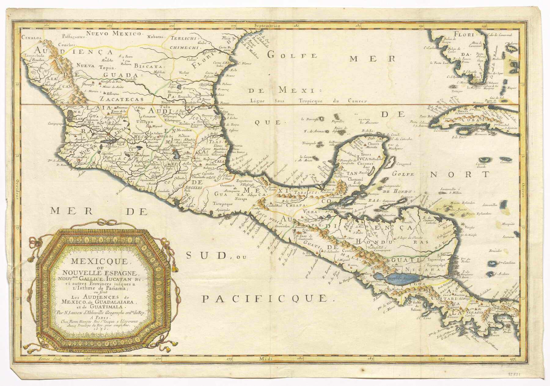
Mexicque, ou Nouvelle Espagne, Nouvelle Gallice, Iucatan & c. et autres Provinces jusques a L'Isthme de Panama; ou font les Audiences de Mexico, de Guadalaiara, et de Guatimala
-
Map/Doc
95831
-
Collection
General Map Collection
-
Object Dates
1656 (Creation Date)
-
People and Organizations
N. Sanson (Cartographer)
-
Subjects
Central America Mexico
-
Height x Width
15.7 x 22.3 inches
39.9 x 56.6 cm
-
Medium
paper, etching/engraving/lithograph
Part of: General Map Collection
The Great European Alliance against the Mexican Republic

Print $20.00
- Digital $50.00
The Great European Alliance against the Mexican Republic
1861
Size 22.9 x 16.2 inches
Map/Doc 96429
Colorado River, Glen Flora Sheet

Print $6.00
- Digital $50.00
Colorado River, Glen Flora Sheet
1941
Size 24.5 x 32.6 inches
Map/Doc 65310
Nueces County Rolled Sketch 123

Print $20.00
- Digital $50.00
Nueces County Rolled Sketch 123
1997
Size 18.2 x 24.9 inches
Map/Doc 7158
Shelby County Sketch File 8

Print $4.00
- Digital $50.00
Shelby County Sketch File 8
Size 10.1 x 7.9 inches
Map/Doc 36607
Loving County Sketch File 1

Print $4.00
- Digital $50.00
Loving County Sketch File 1
1931
Size 11.2 x 8.6 inches
Map/Doc 30407
Anderson County Sketch File 16a

Print $4.00
- Digital $50.00
Anderson County Sketch File 16a
1853
Size 12.3 x 8.3 inches
Map/Doc 12786
Shackelford County Boundary File 4

Print $2.00
- Digital $50.00
Shackelford County Boundary File 4
Size 6.6 x 8.8 inches
Map/Doc 58660
Flight Mission No. CGI-1N, Frame 177, Cameron County

Print $20.00
- Digital $50.00
Flight Mission No. CGI-1N, Frame 177, Cameron County
1955
Size 18.5 x 17.6 inches
Map/Doc 84512
Flight Mission No. DCL-6C, Frame 98, Kenedy County

Print $20.00
- Digital $50.00
Flight Mission No. DCL-6C, Frame 98, Kenedy County
1943
Size 18.6 x 22.3 inches
Map/Doc 85928
Water-Shed of the Brazos River

Print $40.00
- Digital $50.00
Water-Shed of the Brazos River
1925
Size 35.0 x 88.0 inches
Map/Doc 65263
North Sulphur River, Bartley Gin Sheet

Print $20.00
- Digital $50.00
North Sulphur River, Bartley Gin Sheet
1928
Size 13.3 x 22.0 inches
Map/Doc 78323
Sketch of 103rd Meridian, W. L. Showing Conflict of Capitol Leagues

Print $40.00
- Digital $50.00
Sketch of 103rd Meridian, W. L. Showing Conflict of Capitol Leagues
Size 26.9 x 85.1 inches
Map/Doc 65505
You may also like
Potter County Sketch File 15

Print $20.00
- Digital $50.00
Potter County Sketch File 15
Size 19.5 x 21.1 inches
Map/Doc 12201
Lipscomb County Rolled Sketch 5

Print $40.00
- Digital $50.00
Lipscomb County Rolled Sketch 5
Size 60.5 x 8.0 inches
Map/Doc 81427
Palo Pinto County, Texas

Print $20.00
- Digital $50.00
Palo Pinto County, Texas
1879
Size 17.8 x 19.0 inches
Map/Doc 529
![94186, Texas [Verso], General Map Collection](https://historictexasmaps.com/wmedia_w700/maps/94186.tif.jpg)
El Paso County Rolled Sketch 52

Print $20.00
- Digital $50.00
El Paso County Rolled Sketch 52
1929
Size 18.5 x 24.4 inches
Map/Doc 5838
Harris County Working Sketch 115

Print $40.00
- Digital $50.00
Harris County Working Sketch 115
1983
Size 48.8 x 44.5 inches
Map/Doc 66007
Hunt County Boundary File 2a

Print $30.00
- Digital $50.00
Hunt County Boundary File 2a
Size 14.2 x 8.7 inches
Map/Doc 55192
Hardin County Working Sketch 22

Print $20.00
- Digital $50.00
Hardin County Working Sketch 22
1948
Size 20.9 x 31.6 inches
Map/Doc 63420
Bexar County State Real Property Sketch 3

Print $20.00
- Digital $50.00
Bexar County State Real Property Sketch 3
2000
Size 18.8 x 22.5 inches
Map/Doc 61671
Hardin County Rolled Sketch 8

Print $20.00
- Digital $50.00
Hardin County Rolled Sketch 8
1947
Size 23.7 x 25.8 inches
Map/Doc 6081
Working Sketch, Bastrop County

Print $3.00
- Digital $50.00
Working Sketch, Bastrop County
1923
Size 10.1 x 15.3 inches
Map/Doc 90113
