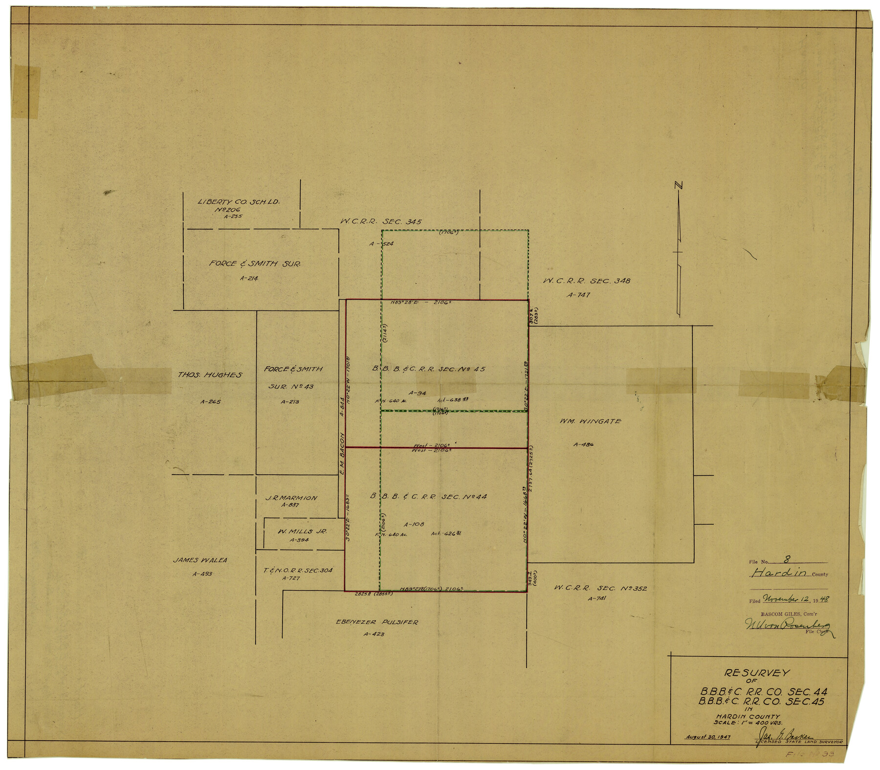
Hardin County Rolled Sketch 8
Resurvey of B. B. B. & C. R.R. Co. sec. 44, B. B. B. & C. R.R. Co. sec. 45 in Hardin County
-
Map/Doc
6081
-
Collection
General Map Collection
-
Object Dates
8/30/1947 (Creation Date)
11/12/1948 (File Date)
-
People and Organizations
Jas. G. Barker (Surveyor/Engineer)
-
Counties
Hardin
-
Subjects
Surveying Rolled Sketch
-
Height x Width
23.7 x 25.8 inches
60.2 x 65.5 cm
-
Medium
van dyke/brownline/sepia
-
Scale
1" = 400 varas
Part of: General Map Collection
Val Verde County Sketch File 19a

Print $42.00
- Digital $50.00
Val Verde County Sketch File 19a
Size 29.4 x 15.1 inches
Map/Doc 12568
Travis County Sketch File 12

Print $4.00
- Digital $50.00
Travis County Sketch File 12
1850
Size 12.7 x 8.2 inches
Map/Doc 38304
Wilbarger County Sketch File 20

Print $4.00
- Digital $50.00
Wilbarger County Sketch File 20
1885
Size 12.7 x 8.2 inches
Map/Doc 40217
Hemphill County

Print $20.00
- Digital $50.00
Hemphill County
1932
Size 39.9 x 36.6 inches
Map/Doc 73177
Hutchinson County Sketch File 18

Print $28.00
- Digital $50.00
Hutchinson County Sketch File 18
1909
Size 6.7 x 8.3 inches
Map/Doc 27220
Leon County Rolled Sketch 35

Print $20.00
- Digital $50.00
Leon County Rolled Sketch 35
2018
Size 30.7 x 21.3 inches
Map/Doc 95288
Waller County

Print $20.00
- Digital $50.00
Waller County
1945
Size 46.4 x 27.1 inches
Map/Doc 77449

Stonewall County Sketch File B2

Print $20.00
- Digital $50.00
Stonewall County Sketch File B2
1902
Size 25.8 x 25.0 inches
Map/Doc 12377
Liberty County Sketch File 52

Print $20.00
- Digital $50.00
Liberty County Sketch File 52
Size 17.5 x 13.5 inches
Map/Doc 11995
Crockett County Working Sketch 93

Print $40.00
- Digital $50.00
Crockett County Working Sketch 93
1979
Size 43.5 x 65.4 inches
Map/Doc 68426
Calhoun County Rolled Sketch 8

Print $40.00
- Digital $50.00
Calhoun County Rolled Sketch 8
1921
Size 25.6 x 53.4 inches
Map/Doc 5364
You may also like
General Highway Map, Hemphill County, Texas

Print $20.00
General Highway Map, Hemphill County, Texas
1961
Size 18.3 x 24.6 inches
Map/Doc 79515
Map of Trespalacios River & Bay in Matagorda County showing subdivision thereof for mineral development

Print $20.00
- Digital $50.00
Map of Trespalacios River & Bay in Matagorda County showing subdivision thereof for mineral development
1937
Size 30.5 x 38.9 inches
Map/Doc 3022
A Pocket Guide to Austin, Texas - Area Map and Downtown Map

A Pocket Guide to Austin, Texas - Area Map and Downtown Map
Size 17.2 x 20.2 inches
Map/Doc 94386
Hunt County Sketch File 5

Print $4.00
- Digital $50.00
Hunt County Sketch File 5
1851
Size 12.9 x 8.2 inches
Map/Doc 27091
Shelby County Sketch File 29

Print $4.00
- Digital $50.00
Shelby County Sketch File 29
Size 8.1 x 12.8 inches
Map/Doc 36666
[Sketch for Mineral Application 13439 - Old River, Walle Merritt]
![65688, [Sketch for Mineral Application 13439 - Old River, Walle Merritt], General Map Collection](https://historictexasmaps.com/wmedia_w700/maps/65688-1.tif.jpg)
Print $20.00
- Digital $50.00
[Sketch for Mineral Application 13439 - Old River, Walle Merritt]
1925
Size 41.2 x 18.9 inches
Map/Doc 65688
Brewster County Rolled Sketch 49B

Print $20.00
- Digital $50.00
Brewster County Rolled Sketch 49B
Size 14.2 x 24.2 inches
Map/Doc 5225
Subdivision of the J. F. Carter Estate

Print $3.00
- Digital $50.00
Subdivision of the J. F. Carter Estate
Size 11.9 x 9.4 inches
Map/Doc 91272
Flight Mission No. BQY-15M, Frame 20, Harris County

Print $20.00
- Digital $50.00
Flight Mission No. BQY-15M, Frame 20, Harris County
1953
Size 18.6 x 22.3 inches
Map/Doc 85318
Edwards County Working Sketch 42

Print $20.00
- Digital $50.00
Edwards County Working Sketch 42
1949
Size 25.5 x 31.4 inches
Map/Doc 68918
[Sketch for Mineral Application 18874 - Pecos River Bed, W. J. Bonner]
![65584, [Sketch for Mineral Application 18874 - Pecos River Bed, W. J. Bonner], General Map Collection](https://historictexasmaps.com/wmedia_w700/maps/65584.tif.jpg)
Print $20.00
- Digital $50.00
[Sketch for Mineral Application 18874 - Pecos River Bed, W. J. Bonner]
1927
Size 37.5 x 31.6 inches
Map/Doc 65584
[North part of G. C. & S. F. Block OP, Runnels County School Land]
![90309, [North part of G. C. & S. F. Block OP, Runnels County School Land], Twichell Survey Records](https://historictexasmaps.com/wmedia_w700/maps/90309-1.tif.jpg)
Print $20.00
- Digital $50.00
[North part of G. C. & S. F. Block OP, Runnels County School Land]
Size 14.3 x 17.6 inches
Map/Doc 90309