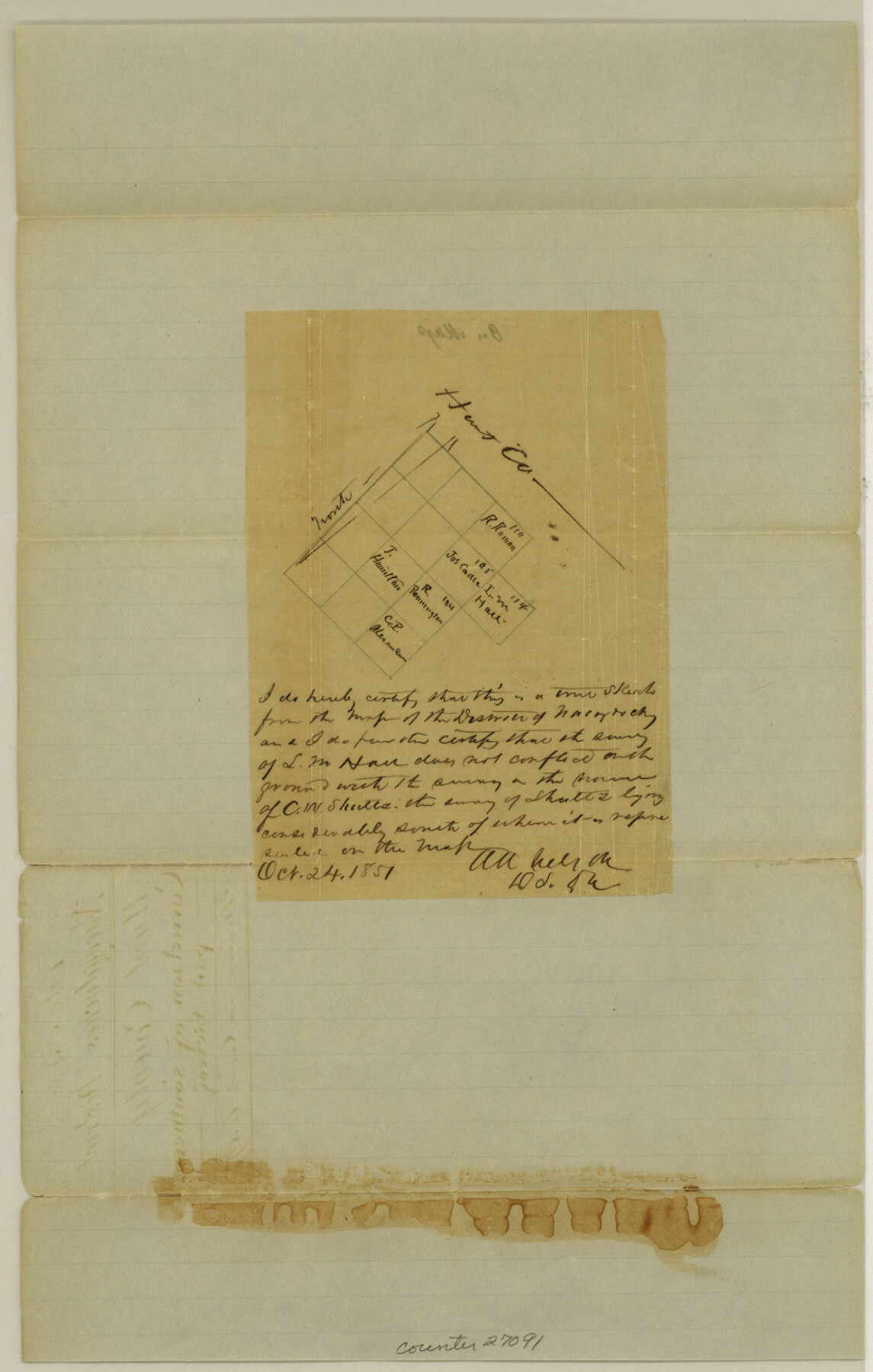
Hunt County Sketch File 5
[Sketch of surveys in southern part of county]
-
Map/Doc
27091
-
Collection
General Map Collection
-
Object Dates
10/24/1851 (Creation Date)
-
People and Organizations
A.A. Nelson (Surveyor/Engineer)
A.A. Nelson (Draftsman)
-
Counties
Hunt
-
Subjects
Surveying Sketch File
-
Height x Width
12.9 x 8.2 inches
32.8 x 20.8 cm
-
Medium
paper, manuscript
Part of: General Map Collection
Official Map of the State of Texas to accompany the Statistical and Descriptive Work, "Resources, Soil and Climate of Texas"

Print $20.00
- Digital $50.00
Official Map of the State of Texas to accompany the Statistical and Descriptive Work, "Resources, Soil and Climate of Texas"
1882
Size 31.1 x 33.1 inches
Map/Doc 2134
Gregg County Sketch File 11

Print $12.00
- Digital $50.00
Gregg County Sketch File 11
1933
Size 14.4 x 8.9 inches
Map/Doc 24591
Ward County Boundary File 3

Print $18.00
- Digital $50.00
Ward County Boundary File 3
Size 14.4 x 8.8 inches
Map/Doc 59675
Map of Denton County

Print $20.00
- Digital $50.00
Map of Denton County
1897
Size 42.7 x 39.5 inches
Map/Doc 4932
Flight Mission No. BQR-14K, Frame 37, Brazoria County

Print $20.00
- Digital $50.00
Flight Mission No. BQR-14K, Frame 37, Brazoria County
1952
Size 18.6 x 22.2 inches
Map/Doc 84094
Brazoria County Working Sketch 33

Print $20.00
- Digital $50.00
Brazoria County Working Sketch 33
1980
Size 29.6 x 35.6 inches
Map/Doc 67518

Map of Trinity County Texas

Print $20.00
- Digital $50.00
Map of Trinity County Texas
1859
Size 21.5 x 30.6 inches
Map/Doc 4095
Menard County Working Sketch 13

Print $20.00
- Digital $50.00
Menard County Working Sketch 13
1939
Size 27.3 x 38.1 inches
Map/Doc 70960
Crosby County Rolled Sketch 2

Print $20.00
- Digital $50.00
Crosby County Rolled Sketch 2
1980
Size 24.7 x 18.7 inches
Map/Doc 5642
[Sketch for Mineral Application 13271- Trinity River]
![65627, [Sketch for Mineral Application 13271- Trinity River], General Map Collection](https://historictexasmaps.com/wmedia_w700/maps/65627.tif.jpg)
Print $40.00
- Digital $50.00
[Sketch for Mineral Application 13271- Trinity River]
1925
Size 63.4 x 25.0 inches
Map/Doc 65627
Sherman County Sketch File 6

Print $2.00
- Digital $50.00
Sherman County Sketch File 6
1993
Size 14.6 x 9.1 inches
Map/Doc 36724
You may also like
[Surveying Sketch of M. Farley, R. Word, S. S. Hervey, et al in Kleberg County, Texas]
![10783, [Surveying Sketch of M. Farley, R. Word, S. S. Hervey, et al in Kleberg County, Texas], Maddox Collection](https://historictexasmaps.com/wmedia_w700/maps/10783.tif.jpg)
Print $20.00
- Digital $50.00
[Surveying Sketch of M. Farley, R. Word, S. S. Hervey, et al in Kleberg County, Texas]
Size 23.2 x 40.6 inches
Map/Doc 10783
Concho County Sketch File 22

Print $20.00
- Digital $50.00
Concho County Sketch File 22
Size 24.9 x 18.1 inches
Map/Doc 11155
Bandera County

Print $40.00
- Digital $50.00
Bandera County
1904
Size 33.0 x 52.5 inches
Map/Doc 66710
Terrell County Working Sketch 85

Print $20.00
- Digital $50.00
Terrell County Working Sketch 85
1994
Size 31.3 x 42.8 inches
Map/Doc 69609
Map Prepared from Data by Original Field Book by W.D. Twichell

Print $40.00
- Digital $50.00
Map Prepared from Data by Original Field Book by W.D. Twichell
Size 64.0 x 40.0 inches
Map/Doc 89733
Denton County Working Sketch 4

Print $20.00
- Digital $50.00
Denton County Working Sketch 4
1940
Size 23.6 x 24.6 inches
Map/Doc 68609
Johnson County Boundary File 51b

Print $80.00
- Digital $50.00
Johnson County Boundary File 51b
Size 53.9 x 9.4 inches
Map/Doc 55619


The Republic County of Washington. January 29, 1842

Print $20.00
The Republic County of Washington. January 29, 1842
2020
Size 11.8 x 21.7 inches
Map/Doc 96307
Randall County Sketch File 1

Print $50.00
- Digital $50.00
Randall County Sketch File 1
1912
Size 24.6 x 35.6 inches
Map/Doc 12205
Station Map, the Missouri, Kansas and Texas Ry. Of Texas - Henrietta Division

Print $20.00
- Digital $50.00
Station Map, the Missouri, Kansas and Texas Ry. Of Texas - Henrietta Division
1918
Size 11.9 x 26.9 inches
Map/Doc 64765