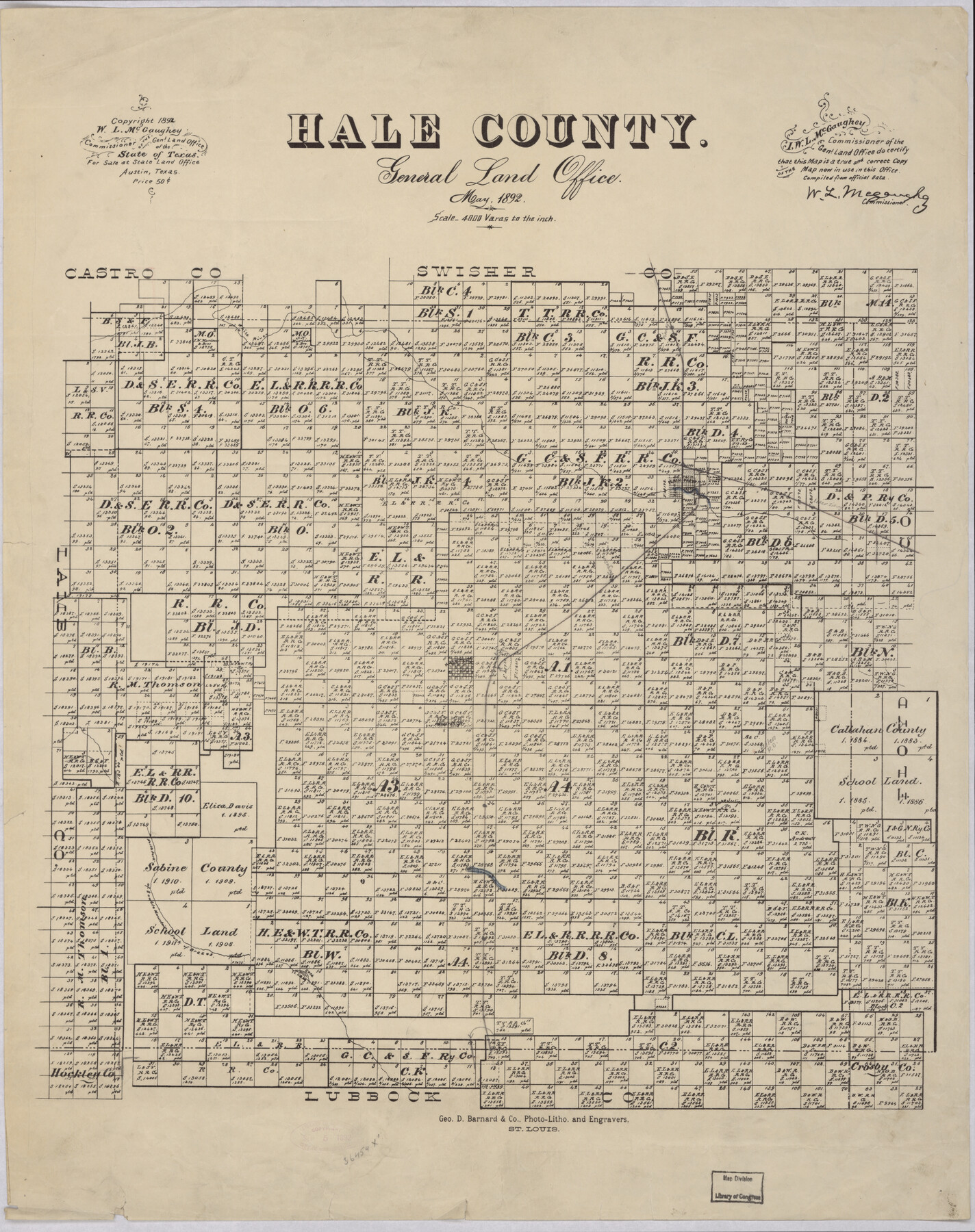
Hale County
-
Map/Doc
88944
-
Collection
Library of Congress
-
Object Dates
5/1892 (Creation Date)
-
People and Organizations
General Land Office (Publisher)
George D. Barnard and Company (Printer)
W.L. McGaughey (GLO Commissioner)
-
Counties
Hale
-
Subjects
County
-
Height x Width
24.4 x 19.3 inches
62.0 x 49.0 cm
-
Comments
Prints available from the GLO courtesy of Library of Congress, Geography and Map Division. Map notes that "For Sale at State Land Office Austin Tex, Price $0.50"
Part of: Library of Congress
Houston, Texas (Looking South)

Print $20.00
Houston, Texas (Looking South)
1891
Size 41.1 x 25.3 inches
Map/Doc 93465
J. De Cordova's Map of the State of Texas Compiled from the records of the General Land Office of the State

Print $20.00
J. De Cordova's Map of the State of Texas Compiled from the records of the General Land Office of the State
1853
Size 35.0 x 35.0 inches
Map/Doc 88903

Map of Texas showing the Sabine and Galveston Bay Rail Road, or Texas and New Orleans Air Line Rail Line, its connections in the U.S. and adjacent territories.

Print $20.00
Map of Texas showing the Sabine and Galveston Bay Rail Road, or Texas and New Orleans Air Line Rail Line, its connections in the U.S. and adjacent territories.
1859
Size 28.7 x 41.3 inches
Map/Doc 93610
Ladonia, Fannin County, Texas

Print $20.00
Ladonia, Fannin County, Texas
1891
Size 12.3 x 22.3 inches
Map/Doc 93475
Map of Portions of Eastland, Brown and Comanche Counties

Print $20.00
Map of Portions of Eastland, Brown and Comanche Counties
Size 21.7 x 16.7 inches
Map/Doc 88926


Plano del Lago de Sn. Bernardo situado en la costa del N. del Seno Mexicano su entrada en la L. N. de 28° 24' y en la Long. de 278° 27' segun el Meridiano de Tenerife

Print $20.00
Plano del Lago de Sn. Bernardo situado en la costa del N. del Seno Mexicano su entrada en la L. N. de 28° 24' y en la Long. de 278° 27' segun el Meridiano de Tenerife
Size 7.9 x 17.3 inches
Map/Doc 93616
Map showing the distribution of the slave population of the southern states of the United States. Compiled from the census of 1860

Print $20.00
Map showing the distribution of the slave population of the southern states of the United States. Compiled from the census of 1860
1861
Size 27.8 x 34.8 inches
Map/Doc 95749

Gray's railroad map of Texas.

Print $20.00
Gray's railroad map of Texas.
1878
Size 26.4 x 16.1 inches
Map/Doc 93597
You may also like
Victoria County Sketch File 4

Print $7.00
- Digital $50.00
Victoria County Sketch File 4
1876
Size 10.1 x 8.2 inches
Map/Doc 39517
Flight Mission No. DIX-7P, Frame 93, Aransas County

Print $20.00
- Digital $50.00
Flight Mission No. DIX-7P, Frame 93, Aransas County
1956
Size 18.6 x 22.6 inches
Map/Doc 83887
Kerr County Boundary File 5

Print $8.00
- Digital $50.00
Kerr County Boundary File 5
Size 14.2 x 8.7 inches
Map/Doc 64818
de Leon Empresario Colony. April 30, 1829

Print $20.00
de Leon Empresario Colony. April 30, 1829
2020
Size 18.5 x 21.7 inches
Map/Doc 95990
Winkler County Sketch File 4

Print $8.00
- Digital $50.00
Winkler County Sketch File 4
Size 14.3 x 8.8 inches
Map/Doc 40463
Andrews County Rolled Sketch 36

Print $20.00
- Digital $50.00
Andrews County Rolled Sketch 36
Size 22.1 x 18.6 inches
Map/Doc 77178
Map of Midland County

Print $20.00
- Digital $50.00
Map of Midland County
1901
Size 43.9 x 38.3 inches
Map/Doc 7825
Red River County Working Sketch 81-3

Print $20.00
- Digital $50.00
Red River County Working Sketch 81-3
1987
Size 17.5 x 21.5 inches
Map/Doc 72066
Right of Way and Track Map of The Missouri, Kansas & Texas Railway of Texas

Print $40.00
- Digital $50.00
Right of Way and Track Map of The Missouri, Kansas & Texas Railway of Texas
1918
Size 24.9 x 53.1 inches
Map/Doc 64537
Val Verde County Working Sketch 28

Print $20.00
- Digital $50.00
Val Verde County Working Sketch 28
1937
Size 45.9 x 38.6 inches
Map/Doc 72163
Jasper County Sketch File 35

Print $6.00
- Digital $50.00
Jasper County Sketch File 35
Size 17.0 x 10.7 inches
Map/Doc 27870
Flight Mission No. BRA-7M, Frame 198, Jefferson County

Print $20.00
- Digital $50.00
Flight Mission No. BRA-7M, Frame 198, Jefferson County
1953
Size 18.7 x 22.4 inches
Map/Doc 85566