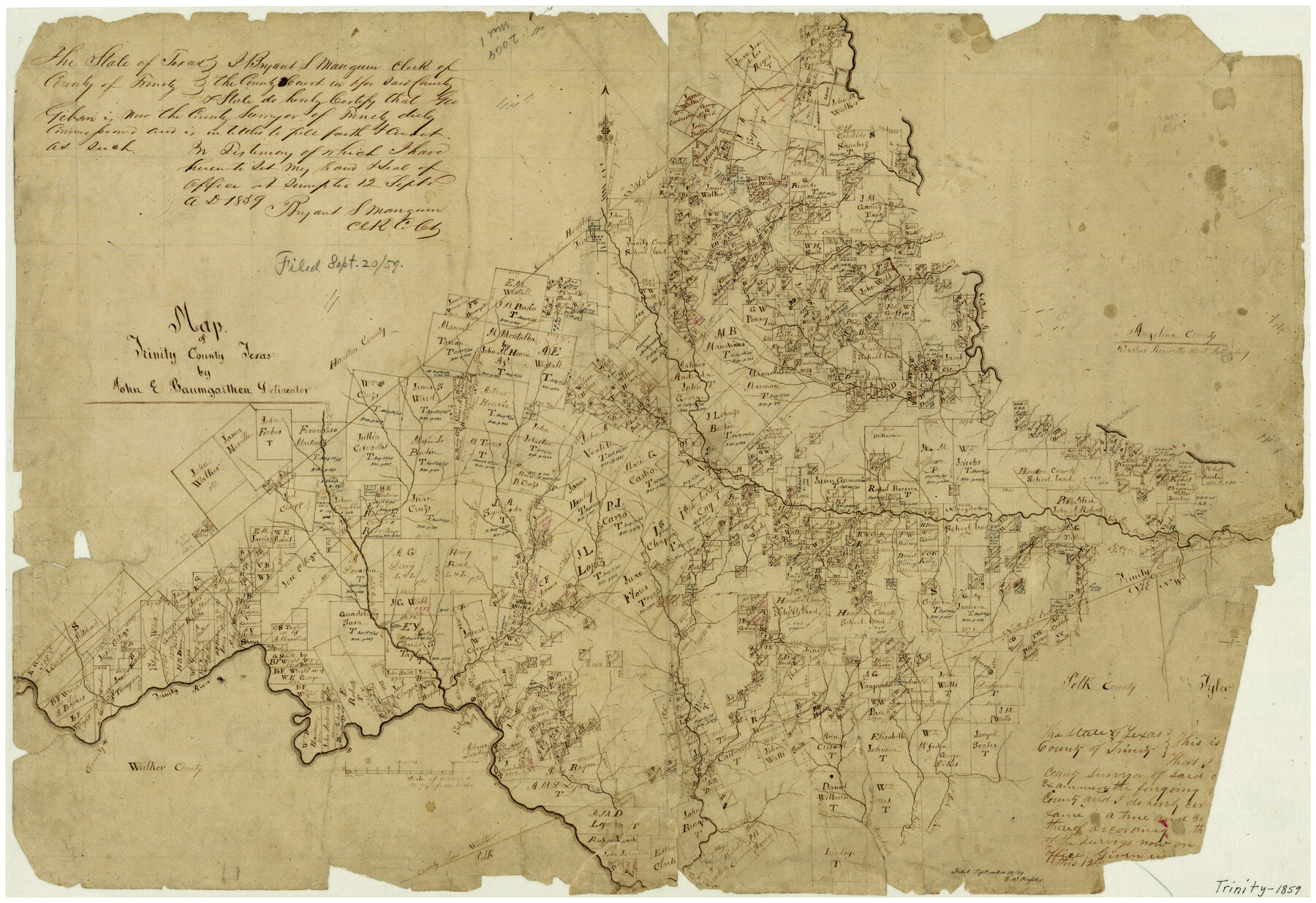
Map of Trinity County Texas
-
Map/Doc
4095
-
Collection
General Map Collection
-
Object Dates
1859 (Creation Date)
9/20/1859 (File Date)
-
People and Organizations
John E. Baumgarthen (Draftsman)
Geo. Gibson (Surveyor/Engineer)
-
Counties
Trinity
-
Subjects
County
-
Height x Width
21.5 x 30.6 inches
54.6 x 77.7 cm
-
Features
Paces Creek
Wright Creek
Cincinaty [sic]
Sebastapool Ferry
Rocky Creek
Moscow
East Fork of Long King [Creek]
Long King Creek
Long Tom Creek
Dillard Creek
Sumptor [sic]
Fountain Creek
Road to Crockett
Salt Creek
McManus Creek
Peachy Creek
Adams Landing
Ferry
White Creek
Elm Creek
Cedar Creek
Hackberry Creek
Sandy Creek
Big Piney Creek
Naches [sic] River
Alabama Creek
Prairie Creek
Cochiney Creek
White Oak Creek
Soap Creek
Bull Creek
Kickapoo Creek
Caney Creek
White Rock Creek
Chalk Creek
Trinity River
Part of: General Map Collection
Harris County Sketch File 70

Print $12.00
- Digital $50.00
Harris County Sketch File 70
1938
Size 11.3 x 8.8 inches
Map/Doc 25518
Wilbarger County Boundary File 1b

Print $40.00
- Digital $50.00
Wilbarger County Boundary File 1b
Size 14.3 x 8.8 inches
Map/Doc 59943
DeWitt County Working Sketch 14

Print $20.00
- Digital $50.00
DeWitt County Working Sketch 14
1988
Size 26.3 x 29.0 inches
Map/Doc 68604
Schleicher County Working Sketch 13

Print $20.00
- Digital $50.00
Schleicher County Working Sketch 13
1926
Size 19.6 x 16.2 inches
Map/Doc 63815
Flight Mission No. DQO-8K, Frame 66, Galveston County

Print $20.00
- Digital $50.00
Flight Mission No. DQO-8K, Frame 66, Galveston County
1952
Size 18.7 x 22.4 inches
Map/Doc 85170
Dimmit County Working Sketch 45

Print $20.00
- Digital $50.00
Dimmit County Working Sketch 45
1979
Size 44.7 x 35.5 inches
Map/Doc 68706
[Texas & Pacific Railway, Longview to Dallas]
![64098, [Texas & Pacific Railway, Longview to Dallas], General Map Collection](https://historictexasmaps.com/wmedia_w700/maps/64098.tif.jpg)
Print $40.00
- Digital $50.00
[Texas & Pacific Railway, Longview to Dallas]
1873
Size 14.5 x 121.6 inches
Map/Doc 64098
Live Oak County Rolled Sketch 1

Print $20.00
- Digital $50.00
Live Oak County Rolled Sketch 1
1943
Size 25.6 x 42.4 inches
Map/Doc 6631
Liberty County Working Sketch 9

Print $20.00
- Digital $50.00
Liberty County Working Sketch 9
Size 34.6 x 27.3 inches
Map/Doc 70468
Galveston County NRC Article 33.136 Sketch 94

Print $72.00
Galveston County NRC Article 33.136 Sketch 94
2024
Map/Doc 97293

Leon County Sketch File 6

Print $4.00
- Digital $50.00
Leon County Sketch File 6
1859
Size 8.2 x 12.0 inches
Map/Doc 29719
You may also like
Motley County Sketch File 8 (N)

Print $6.00
- Digital $50.00
Motley County Sketch File 8 (N)
1901
Size 13.2 x 8.1 inches
Map/Doc 32016
[Lubbock County Sketch, Blocks D7, A, and vicinity]
![91310, [Lubbock County Sketch, Blocks D7, A, and vicinity], Twichell Survey Records](https://historictexasmaps.com/wmedia_w700/maps/91310-1.tif.jpg)
Print $20.00
- Digital $50.00
[Lubbock County Sketch, Blocks D7, A, and vicinity]
1945
Size 18.2 x 29.2 inches
Map/Doc 91310
Upton County Boundary File 1b

Print $28.00
- Digital $50.00
Upton County Boundary File 1b
Size 13.5 x 9.1 inches
Map/Doc 59512

Flight Mission No. CUG-3P, Frame 161, Kleberg County

Print $20.00
- Digital $50.00
Flight Mission No. CUG-3P, Frame 161, Kleberg County
1956
Size 18.6 x 22.5 inches
Map/Doc 86281
The Republic County of Goliad. Proposed, Late Fall 1837-December 31, 1838

Print $20.00
The Republic County of Goliad. Proposed, Late Fall 1837-December 31, 1838
2020
Size 15.1 x 21.7 inches
Map/Doc 96148
Medina County Working Sketch 9

Print $20.00
- Digital $50.00
Medina County Working Sketch 9
1959
Size 25.3 x 38.8 inches
Map/Doc 70924
Jefferson County Rolled Sketch 12

Print $2.00
- Digital $50.00
Jefferson County Rolled Sketch 12
Size 12.2 x 7.1 inches
Map/Doc 9279
Stephens County Sketch File 19

Print $14.00
- Digital $50.00
Stephens County Sketch File 19
1919
Size 8.9 x 7.8 inches
Map/Doc 37077
Hudspeth County Working Sketch 29

Print $40.00
- Digital $50.00
Hudspeth County Working Sketch 29
1972
Size 31.5 x 55.2 inches
Map/Doc 66311
Pecos County Working Sketch 100

Print $20.00
- Digital $50.00
Pecos County Working Sketch 100
1970
Size 42.9 x 31.6 inches
Map/Doc 71573
[Sections 6 and 7, Block 12, H. & G. N.]
![91584, [Sections 6 and 7, Block 12, H. & G. N.], Twichell Survey Records](https://historictexasmaps.com/wmedia_w700/maps/91584-1.tif.jpg)
Print $2.00
- Digital $50.00
[Sections 6 and 7, Block 12, H. & G. N.]
Size 12.4 x 9.2 inches
Map/Doc 91584