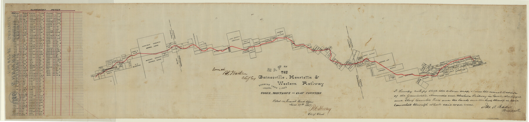
Map of the Gainesville, Henrietta & Western Railway
Z-2-146
-
Map/Doc
64482
-
Collection
General Map Collection
-
Object Dates
1887 (Creation Date)
1887/6/27 (File Date)
-
Counties
Cooke Montague Clay
-
Subjects
Railroads
-
Height x Width
9.6 x 41.7 inches
24.4 x 105.9 cm
-
Medium
paper, manuscript
-
Comments
Shows land lines through Cooke, Montague and Clay Counties; from Henrietta to Gainsville.
-
Features
GH&W
Henrietta
Gainesville
Part of: General Map Collection
Controlled Mosaic by Jack Amman Photogrammetric Engineers, Inc - Sheet 44

Print $20.00
- Digital $50.00
Controlled Mosaic by Jack Amman Photogrammetric Engineers, Inc - Sheet 44
1954
Size 20.0 x 24.0 inches
Map/Doc 83503
Dawson County Working Sketch 21

Print $20.00
- Digital $50.00
Dawson County Working Sketch 21
1963
Size 24.0 x 24.0 inches
Map/Doc 68565
Goliad County Sketch File 37

Print $4.00
- Digital $50.00
Goliad County Sketch File 37
1850
Size 10.2 x 8.3 inches
Map/Doc 24336
Menard County Rolled Sketch 10

Print $20.00
- Digital $50.00
Menard County Rolled Sketch 10
1955
Size 46.7 x 37.7 inches
Map/Doc 9511
Castro County

Print $20.00
- Digital $50.00
Castro County
1932
Size 39.2 x 34.4 inches
Map/Doc 77234
Live Oak County

Print $40.00
- Digital $50.00
Live Oak County
1899
Size 52.1 x 37.5 inches
Map/Doc 78423
Sutton County Sketch File 6a

Print $6.00
- Digital $50.00
Sutton County Sketch File 6a
1898
Size 7.5 x 6.4 inches
Map/Doc 37362
Haskell County Boundary File 5

Print $80.00
- Digital $50.00
Haskell County Boundary File 5
Size 16.5 x 11.9 inches
Map/Doc 54578
Flight Mission No. DQN-2K, Frame 81, Calhoun County

Print $20.00
- Digital $50.00
Flight Mission No. DQN-2K, Frame 81, Calhoun County
1953
Size 18.7 x 22.3 inches
Map/Doc 84273
Brazoria County Rolled Sketch 40

Print $20.00
- Digital $50.00
Brazoria County Rolled Sketch 40
1954
Size 32.1 x 21.5 inches
Map/Doc 5175
Fisher County Sketch File Bb

Print $26.00
- Digital $50.00
Fisher County Sketch File Bb
1902
Size 14.3 x 8.7 inches
Map/Doc 22657
Presidio County Sketch File 119

Print $14.00
- Digital $50.00
Presidio County Sketch File 119
1996
Size 14.3 x 9.0 inches
Map/Doc 34927
You may also like
Milam County Sketch File 5

Print $4.00
- Digital $50.00
Milam County Sketch File 5
1901
Size 14.2 x 8.7 inches
Map/Doc 31632
[Blocks 2, M3, M20, G. & M. Block 22 and others in the vicinity]
![91803, [Blocks 2, M3, M20, G. & M. Block 22 and others in the vicinity], Twichell Survey Records](https://historictexasmaps.com/wmedia_w700/maps/91803-1.tif.jpg)
Print $20.00
- Digital $50.00
[Blocks 2, M3, M20, G. & M. Block 22 and others in the vicinity]
Size 19.0 x 23.2 inches
Map/Doc 91803
County Map of the State of Texas Showing also portions of the Adjoining States and Territories (Inset: Plan of Galveston and Vicinity)

Print $20.00
- Digital $50.00
County Map of the State of Texas Showing also portions of the Adjoining States and Territories (Inset: Plan of Galveston and Vicinity)
1873
Size 15.5 x 23.1 inches
Map/Doc 93696
Dallam County Sketch File 5

Print $22.00
- Digital $50.00
Dallam County Sketch File 5
1880
Size 14.2 x 8.8 inches
Map/Doc 20339
Mills County Boundary File 5

Print $8.00
- Digital $50.00
Mills County Boundary File 5
Size 14.2 x 8.7 inches
Map/Doc 57296
Crockett County Working Sketch 42

Print $20.00
- Digital $50.00
Crockett County Working Sketch 42
1930
Size 25.8 x 28.0 inches
Map/Doc 68375
Johnson County Sketch File 14a

Print $6.00
- Digital $50.00
Johnson County Sketch File 14a
1862
Size 8.0 x 11.1 inches
Map/Doc 28452
Uvalde County

Print $20.00
- Digital $50.00
Uvalde County
1976
Size 43.0 x 46.3 inches
Map/Doc 95660
Texas-Indian Territory Gainesville Quadrangle

Print $20.00
- Digital $50.00
Texas-Indian Territory Gainesville Quadrangle
1902
Size 20.4 x 16.9 inches
Map/Doc 75102
Official Map of the State of Texas to accompany the Statistical and Descriptive Work, "Resources, Soil and Climate of Texas"

Print $20.00
Official Map of the State of Texas to accompany the Statistical and Descriptive Work, "Resources, Soil and Climate of Texas"
1882
Size 32.3 x 34.4 inches
Map/Doc 76257
Edwards County Working Sketch 57

Print $20.00
- Digital $50.00
Edwards County Working Sketch 57
1952
Size 22.7 x 32.3 inches
Map/Doc 68933
Crosby County Boundary File 1

Print $20.00
- Digital $50.00
Crosby County Boundary File 1
Size 7.4 x 4.1 inches
Map/Doc 51971