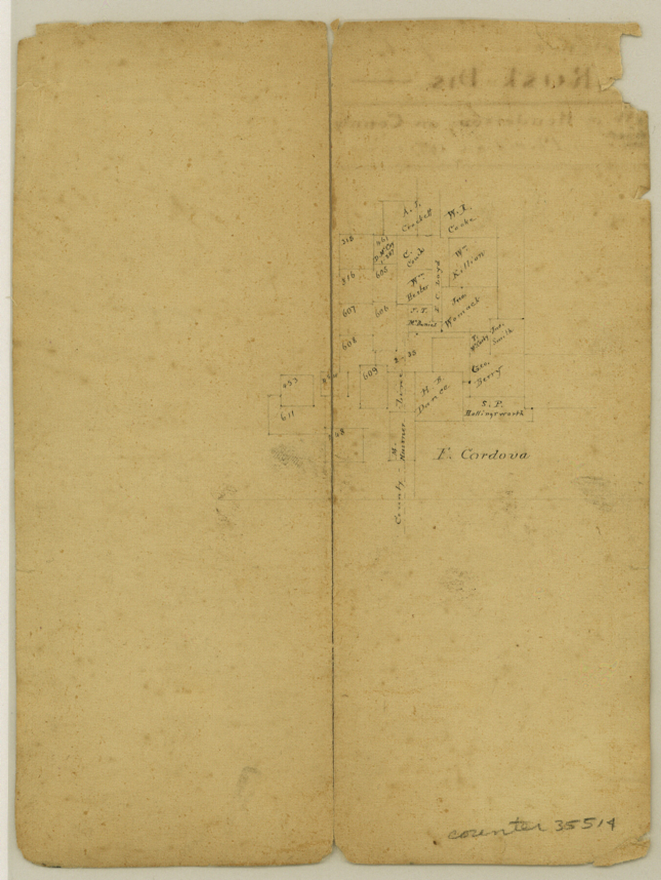
Rusk County Sketch File 13
[Sketch showing area spanning the Rusk-Smith County line northwest of Henderson]
-
Map/Doc
35514
-
Collection
General Map Collection
-
Counties
Rusk Smith
-
Subjects
Surveying Sketch File
-
Height x Width
8.6 x 6.4 inches
21.8 x 16.3 cm
-
Medium
paper, manuscript
Part of: General Map Collection
Jim Hogg County Working Sketch 9

Print $20.00
- Digital $50.00
Jim Hogg County Working Sketch 9
1973
Size 14.3 x 11.2 inches
Map/Doc 66595
Childress County Rolled Sketch 9A

Print $20.00
- Digital $50.00
Childress County Rolled Sketch 9A
Size 17.0 x 17.1 inches
Map/Doc 5447
Nautical Chart 152-SC - Galveston Bay, Texas

Print $20.00
- Digital $50.00
Nautical Chart 152-SC - Galveston Bay, Texas
1972
Size 15.2 x 33.5 inches
Map/Doc 69891
Travis County

Print $40.00
- Digital $50.00
Travis County
1936
Size 46.4 x 54.8 inches
Map/Doc 63076
Crockett County Sketch File 81

Print $4.00
- Digital $50.00
Crockett County Sketch File 81
1939
Size 11.3 x 8.5 inches
Map/Doc 19893
Shelby County Working Sketch 23a

Print $20.00
- Digital $50.00
Shelby County Working Sketch 23a
1983
Size 28.1 x 31.0 inches
Map/Doc 63876
Throckmorton County Rolled Sketch 2

Print $20.00
- Digital $50.00
Throckmorton County Rolled Sketch 2
Size 28.9 x 36.3 inches
Map/Doc 7985
Pecos County Rolled Sketch 186

Print $20.00
- Digital $50.00
Pecos County Rolled Sketch 186
1985
Size 39.3 x 27.5 inches
Map/Doc 7305
Grayson County Boundary File 35

Print $42.00
- Digital $50.00
Grayson County Boundary File 35
Size 9.3 x 7.9 inches
Map/Doc 53961
Webb County Rolled Sketch 17

Print $20.00
- Digital $50.00
Webb County Rolled Sketch 17
1915
Size 16.7 x 14.7 inches
Map/Doc 8180
Trinity River, Balltown Sheet/Pilot Grove Creek

Print $20.00
- Digital $50.00
Trinity River, Balltown Sheet/Pilot Grove Creek
1916
Size 36.9 x 27.5 inches
Map/Doc 65195

You may also like
Flight Mission No. DAG-18K, Frame 73, Matagorda County

Print $20.00
- Digital $50.00
Flight Mission No. DAG-18K, Frame 73, Matagorda County
1952
Size 18.5 x 22.2 inches
Map/Doc 86366
Hood County Rolled Sketch 4

Print $20.00
- Digital $50.00
Hood County Rolled Sketch 4
Size 33.4 x 43.1 inches
Map/Doc 6220
[Block 1, B. S. & F.]
![90492, [Block 1, B. S. & F.], Twichell Survey Records](https://historictexasmaps.com/wmedia_w700/maps/90492-1.tif.jpg)
Print $2.00
- Digital $50.00
[Block 1, B. S. & F.]
1904
Size 8.3 x 10.5 inches
Map/Doc 90492
Map of Atascosa County, Texas

Print $20.00
- Digital $50.00
Map of Atascosa County, Texas
1879
Size 23.7 x 29.0 inches
Map/Doc 688
Mason County Working Sketch 13

Print $20.00
- Digital $50.00
Mason County Working Sketch 13
1954
Size 20.0 x 29.9 inches
Map/Doc 70849
Menard County Working Sketch 30

Print $20.00
- Digital $50.00
Menard County Working Sketch 30
1974
Size 47.9 x 38.8 inches
Map/Doc 70977
Topographical Map of the Rio Grande, Sheet No. 1

Print $20.00
- Digital $50.00
Topographical Map of the Rio Grande, Sheet No. 1
1912
Map/Doc 89525
Burnet County Sketch File 37

Print $2.00
- Digital $50.00
Burnet County Sketch File 37
1935
Size 10.1 x 8.2 inches
Map/Doc 16754
Leon County Working Sketch 7

Print $20.00
- Digital $50.00
Leon County Working Sketch 7
1913
Size 13.7 x 16.7 inches
Map/Doc 70406
[Galveston, Harrisburg & San Antonio Railway]
![64405, [Galveston, Harrisburg & San Antonio Railway], General Map Collection](https://historictexasmaps.com/wmedia_w700/maps/64405.tif.jpg)
Print $20.00
- Digital $50.00
[Galveston, Harrisburg & San Antonio Railway]
1892
Size 13.5 x 33.6 inches
Map/Doc 64405
[Blocks T2 and T3]
![90992, [Blocks T2 and T3], Twichell Survey Records](https://historictexasmaps.com/wmedia_w700/maps/90992-1.tif.jpg)
Print $20.00
- Digital $50.00
[Blocks T2 and T3]
Size 12.2 x 14.6 inches
Map/Doc 90992
Blanco County Working Sketch 42

Print $20.00
- Digital $50.00
Blanco County Working Sketch 42
1986
Size 35.1 x 30.7 inches
Map/Doc 67402