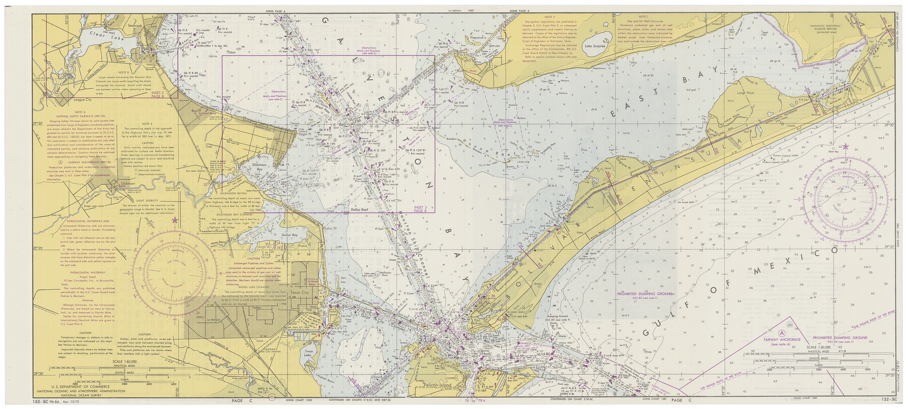
Nautical Chart 152-SC - Galveston Bay, Texas
-
Map/Doc
69891
-
Collection
General Map Collection
-
Object Dates
4/15/1972 (Creation Date)
-
Counties
Chambers Harris Galveston
-
Subjects
Nautical Charts
-
Height x Width
15.2 x 33.5 inches
38.6 x 85.1 cm
Part of: General Map Collection
Eastland County Sketch File 22

Print $33.00
- Digital $50.00
Eastland County Sketch File 22
1964
Size 11.0 x 17.0 inches
Map/Doc 21626
[Right of Way & Track Map, The Texas & Pacific Ry. Co. Main Line]
![64691, [Right of Way & Track Map, The Texas & Pacific Ry. Co. Main Line], General Map Collection](https://historictexasmaps.com/wmedia_w700/maps/64691.tif.jpg)
Print $20.00
- Digital $50.00
[Right of Way & Track Map, The Texas & Pacific Ry. Co. Main Line]
Size 10.9 x 18.6 inches
Map/Doc 64691
Runnels County Working Sketch 28

Print $20.00
- Digital $50.00
Runnels County Working Sketch 28
1959
Size 41.9 x 35.2 inches
Map/Doc 63624

Young Territory

Print $20.00
- Digital $50.00
Young Territory
1873
Size 29.2 x 29.9 inches
Map/Doc 1976
Stonewall County Working Sketch 27

Print $20.00
- Digital $50.00
Stonewall County Working Sketch 27
1976
Size 20.7 x 29.9 inches
Map/Doc 62334
Somervell County Sketch File 7

Print $8.00
- Digital $50.00
Somervell County Sketch File 7
1987
Size 11.4 x 8.9 inches
Map/Doc 36850
Flight Mission No. CRC-2R, Frame 59, Chambers County

Print $20.00
- Digital $50.00
Flight Mission No. CRC-2R, Frame 59, Chambers County
1956
Size 18.7 x 22.5 inches
Map/Doc 84730
Hemphill County Working Sketch 26

Print $40.00
- Digital $50.00
Hemphill County Working Sketch 26
1974
Size 57.2 x 48.3 inches
Map/Doc 66121
Map of section no. 12 of a survey of Padre Island made for the Office of the Attorney General of the State of Texas

Print $40.00
- Digital $50.00
Map of section no. 12 of a survey of Padre Island made for the Office of the Attorney General of the State of Texas
1941
Size 75.9 x 41.0 inches
Map/Doc 2268
Old Miscellaneous File 12

Print $14.00
- Digital $50.00
Old Miscellaneous File 12
1899
Size 14.2 x 8.6 inches
Map/Doc 75439
Boundary and Ownership map, Laguna Atascosa National Wildlife Refuge, Cameron and Willacy Counties, Texas

Print $40.00
- Digital $50.00
Boundary and Ownership map, Laguna Atascosa National Wildlife Refuge, Cameron and Willacy Counties, Texas
1968
Size 73.9 x 43.2 inches
Map/Doc 60395
You may also like
Fayette County Working Sketch 5

Print $20.00
- Digital $50.00
Fayette County Working Sketch 5
1981
Size 16.2 x 14.6 inches
Map/Doc 69169
Upton County Working Sketch 60

Print $20.00
- Digital $50.00
Upton County Working Sketch 60
2012
Size 34.2 x 32.1 inches
Map/Doc 93387
Ector County Working Sketch 14

Print $40.00
- Digital $50.00
Ector County Working Sketch 14
1955
Size 72.7 x 43.4 inches
Map/Doc 68857
Pas Kaart van de Golff van Mexico

Print $20.00
- Digital $50.00
Pas Kaart van de Golff van Mexico
1695
Size 21.4 x 25.4 inches
Map/Doc 94081
Glasscock County Working Sketch 16

Print $40.00
- Digital $50.00
Glasscock County Working Sketch 16
1984
Size 61.2 x 44.0 inches
Map/Doc 63189
Cameron County Rolled Sketch 30

Print $20.00
- Digital $50.00
Cameron County Rolled Sketch 30
1930
Size 36.3 x 24.4 inches
Map/Doc 5394
Montgomery County Sketch File 3

Print $12.00
- Digital $50.00
Montgomery County Sketch File 3
1846
Size 4.5 x 8.3 inches
Map/Doc 31770
Concho County Rolled Sketch 20

Print $20.00
- Digital $50.00
Concho County Rolled Sketch 20
1968
Size 26.2 x 38.8 inches
Map/Doc 5554
Shackelford County Working Sketch 9

Print $20.00
- Digital $50.00
Shackelford County Working Sketch 9
1974
Size 30.1 x 22.2 inches
Map/Doc 63849
[Sketch showing G. & M. Block 5]
![91704, [Sketch showing G. & M. Block 5], Twichell Survey Records](https://historictexasmaps.com/wmedia_w700/maps/91704-1.tif.jpg)
Print $2.00
- Digital $50.00
[Sketch showing G. & M. Block 5]
Size 7.5 x 5.8 inches
Map/Doc 91704
Flight Mission No. DQO-3K, Frame 15, Galveston County

Print $20.00
- Digital $50.00
Flight Mission No. DQO-3K, Frame 15, Galveston County
1952
Size 18.7 x 22.4 inches
Map/Doc 85056
Crane County Rolled Sketch 24

Print $40.00
- Digital $50.00
Crane County Rolled Sketch 24
2002
Size 33.5 x 62.0 inches
Map/Doc 76427