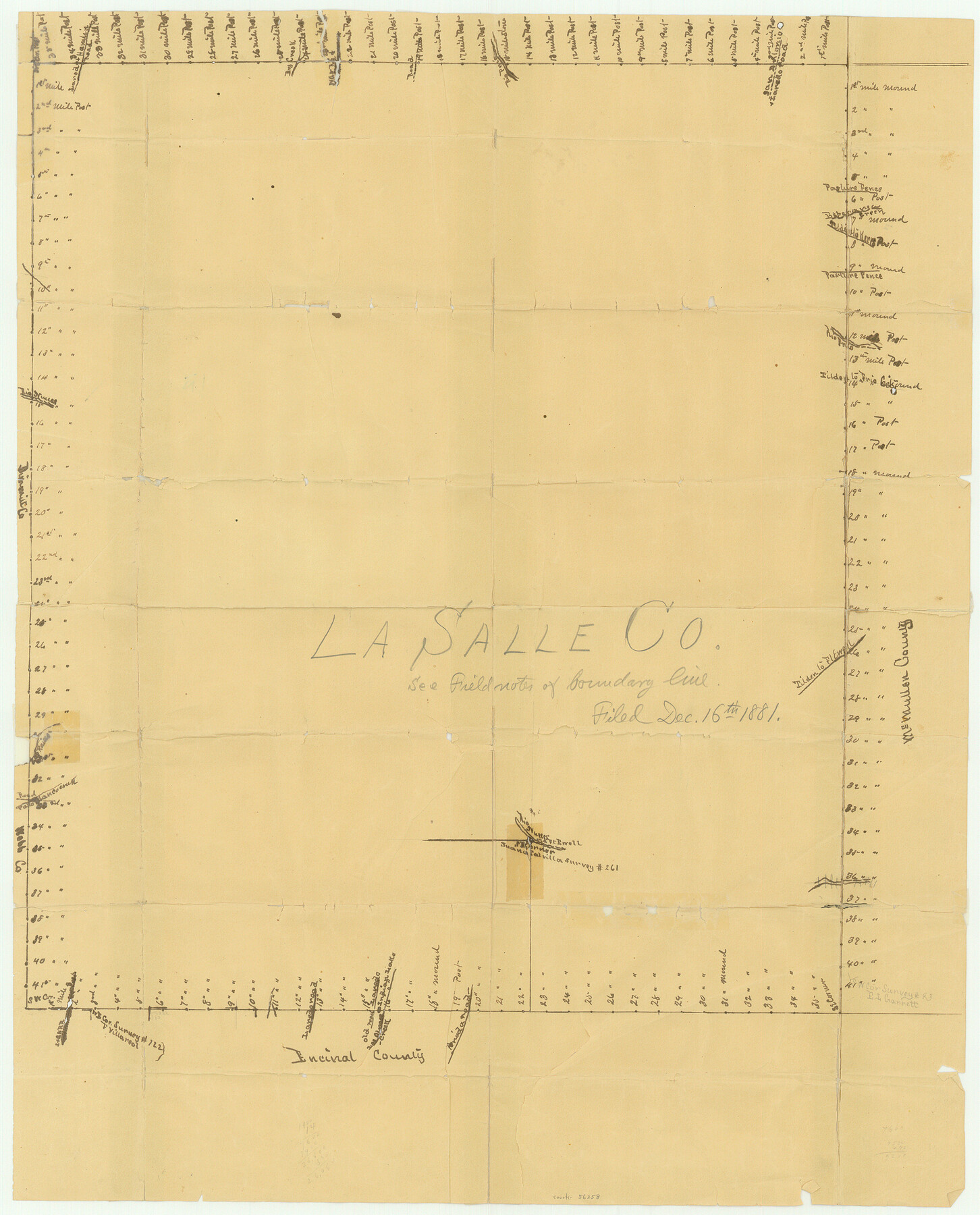
La Salle County Boundary File 57b
-
Map/Doc
56258
-
Collection
General Map Collection
-
Counties
La Salle
-
Subjects
County Boundaries
-
Height x Width
25.6 x 20.6 inches
65.0 x 52.3 cm
Part of: General Map Collection
Medina County Working Sketch 33

Print $20.00
- Digital $50.00
Medina County Working Sketch 33
2006
Size 34.5 x 40.0 inches
Map/Doc 83607
Flight Mission No. DQN-2K, Frame 117, Calhoun County

Print $20.00
- Digital $50.00
Flight Mission No. DQN-2K, Frame 117, Calhoun County
1953
Size 18.3 x 22.1 inches
Map/Doc 84293
Goliad County Sketch File 21

Print $10.00
- Digital $50.00
Goliad County Sketch File 21
1855
Size 12.0 x 7.9 inches
Map/Doc 24284
McCulloch County Sketch File 3

Print $12.00
- Digital $50.00
McCulloch County Sketch File 3
1893
Size 11.1 x 8.5 inches
Map/Doc 31169
Political Essay on the Kingdom of New Spain Vol. 2, Third Edition

Political Essay on the Kingdom of New Spain Vol. 2, Third Edition
1822
Map/Doc 97387
Edwards County Working Sketch 42

Print $20.00
- Digital $50.00
Edwards County Working Sketch 42
1949
Size 25.5 x 31.4 inches
Map/Doc 68918

Montgomery County Rolled Sketch 42

Print $20.00
- Digital $50.00
Montgomery County Rolled Sketch 42
1939
Size 14.1 x 20.1 inches
Map/Doc 6818
Jeff Davis County Boundary File 2a

Print $40.00
- Digital $50.00
Jeff Davis County Boundary File 2a
Size 11.1 x 36.7 inches
Map/Doc 55512
Reagan County Working Sketch 46a

Print $20.00
- Digital $50.00
Reagan County Working Sketch 46a
1970
Size 34.5 x 30.4 inches
Map/Doc 71888
Nueces County NRC Article 33.136 Location Key Sheet

Print $20.00
- Digital $50.00
Nueces County NRC Article 33.136 Location Key Sheet
1975
Size 27.0 x 23.0 inches
Map/Doc 88586
Val Verde County Sketch File 29

Print $20.00
- Digital $50.00
Val Verde County Sketch File 29
Size 33.1 x 23.8 inches
Map/Doc 76760
You may also like
Potter County Boundary File 3e

Print $6.00
- Digital $50.00
Potter County Boundary File 3e
Size 9.2 x 8.0 inches
Map/Doc 57993
Flight Mission No. DIX-5P, Frame 146, Aransas County

Print $20.00
- Digital $50.00
Flight Mission No. DIX-5P, Frame 146, Aransas County
1956
Size 17.7 x 17.9 inches
Map/Doc 83808
Flight Mission No. BRE-2P, Frame 47, Nueces County

Print $20.00
- Digital $50.00
Flight Mission No. BRE-2P, Frame 47, Nueces County
1956
Size 18.6 x 22.6 inches
Map/Doc 86749
Cameron County Rolled Sketch 20A

Print $20.00
- Digital $50.00
Cameron County Rolled Sketch 20A
Size 12.5 x 23.1 inches
Map/Doc 5471
Galveston County NRC Article 33.136 Sketch 31

Print $22.00
- Digital $50.00
Galveston County NRC Article 33.136 Sketch 31
2005
Size 22.2 x 33.7 inches
Map/Doc 83280
Wharton County Sketch File 23

Print $20.00
- Digital $50.00
Wharton County Sketch File 23
Size 19.3 x 19.9 inches
Map/Doc 12667
Fort Bend County Working Sketch 25

Print $40.00
- Digital $50.00
Fort Bend County Working Sketch 25
1981
Size 43.7 x 65.9 inches
Map/Doc 69231
Parker County Boundary File 68

Print $12.00
- Digital $50.00
Parker County Boundary File 68
Size 8.1 x 3.6 inches
Map/Doc 57848
Midland County

Print $20.00
- Digital $50.00
Midland County
1901
Size 43.7 x 40.3 inches
Map/Doc 66929
Culberson County Working Sketch 29

Print $40.00
- Digital $50.00
Culberson County Working Sketch 29
1957
Size 21.8 x 117.6 inches
Map/Doc 68482
Val Verde County Sketch File D

Print $20.00
- Digital $50.00
Val Verde County Sketch File D
1899
Size 29.8 x 40.0 inches
Map/Doc 10422
Val Verde County Working Sketch 62

Print $40.00
- Digital $50.00
Val Verde County Working Sketch 62
1959
Size 38.3 x 56.6 inches
Map/Doc 72197