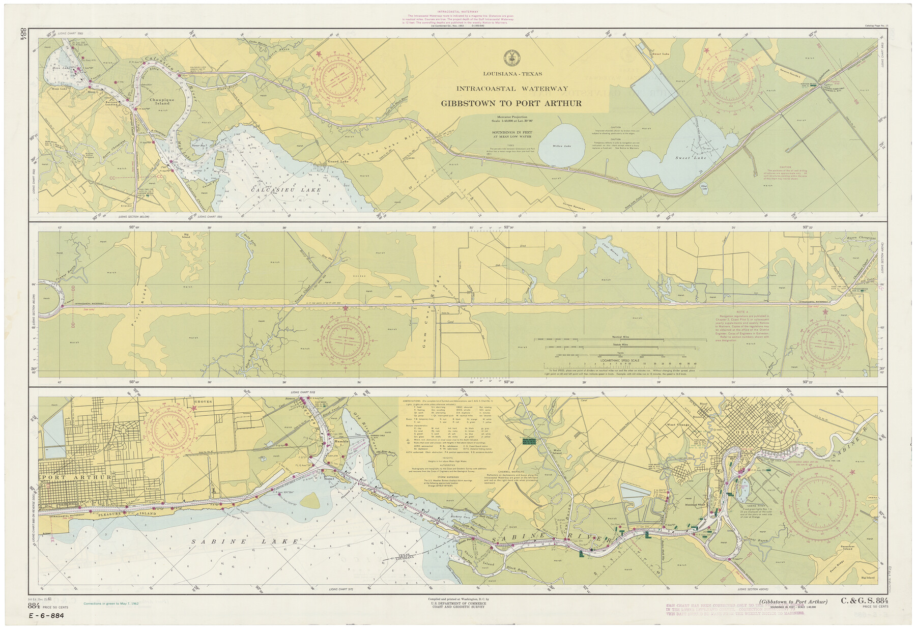
Intracoastal Waterway - Gibbstown to Port Arthur
K-6-884a
-
Map/Doc
69833
-
Collection
General Map Collection
-
Object Dates
1961/12/25 (Creation Date)
-
Counties
Orange Jefferson
-
Subjects
Nautical Charts
-
Height x Width
26.6 x 38.7 inches
67.6 x 98.3 cm
Part of: General Map Collection
Flight Mission No. CUG-1P, Frame 5, Kleberg County

Print $20.00
- Digital $50.00
Flight Mission No. CUG-1P, Frame 5, Kleberg County
1956
Size 18.8 x 22.5 inches
Map/Doc 86108
Johnson County Sketch File 11

Print $8.00
- Digital $50.00
Johnson County Sketch File 11
1880
Size 8.0 x 6.8 inches
Map/Doc 28447
Webb County Sketch File 6-2

Print $20.00
- Digital $50.00
Webb County Sketch File 6-2
1927
Size 29.4 x 21.3 inches
Map/Doc 12616
Flight Mission No. CGI-2N, Frame 180, Cameron County

Print $20.00
- Digital $50.00
Flight Mission No. CGI-2N, Frame 180, Cameron County
1954
Size 18.5 x 22.1 inches
Map/Doc 84540
Orange County Sketch File 43

Print $4.00
- Digital $50.00
Orange County Sketch File 43
1873
Size 8.2 x 10.3 inches
Map/Doc 33385
Anderson County Sketch File 16

Print $6.00
- Digital $50.00
Anderson County Sketch File 16
1849
Size 8.6 x 6.5 inches
Map/Doc 12783
Lynn County Rolled Sketch S

Print $20.00
- Digital $50.00
Lynn County Rolled Sketch S
Size 21.1 x 38.7 inches
Map/Doc 6654

Brewster County Working Sketch 80

Print $20.00
- Digital $50.00
Brewster County Working Sketch 80
1972
Size 44.3 x 39.1 inches
Map/Doc 67680
Galveston County NRC Article 33.136 Sketch 25

Print $26.00
- Digital $50.00
Galveston County NRC Article 33.136 Sketch 25
1999
Size 36.0 x 23.9 inches
Map/Doc 81906
Fayette County

Print $40.00
- Digital $50.00
Fayette County
1978
Size 43.6 x 56.1 inches
Map/Doc 95496
Hansford County Sketch File 8

Print $6.00
- Digital $50.00
Hansford County Sketch File 8
1927
Size 11.3 x 8.7 inches
Map/Doc 24960
You may also like
[T. & P. RR. Co. Blocks 31-36, Townships 3N, 4N and 5N and surrounding area]
![93135, [T. & P. RR. Co. Blocks 31-36, Townships 3N, 4N and 5N and surrounding area], Twichell Survey Records](https://historictexasmaps.com/wmedia_w700/maps/93135-1.tif.jpg)
Print $40.00
- Digital $50.00
[T. & P. RR. Co. Blocks 31-36, Townships 3N, 4N and 5N and surrounding area]
Size 51.3 x 51.5 inches
Map/Doc 93135
Presidio County Sketch File 88

Print $6.00
- Digital $50.00
Presidio County Sketch File 88
Size 14.5 x 8.8 inches
Map/Doc 34751
Plat of South 1/2 of Colorado River Channel in McCulloch Co., Texas from Concho County line down river 34 mile 315 varas

Print $40.00
- Digital $50.00
Plat of South 1/2 of Colorado River Channel in McCulloch Co., Texas from Concho County line down river 34 mile 315 varas
1918
Size 41.1 x 144.3 inches
Map/Doc 76044
The Republic County of San Augustine. December 29, 1845

Print $20.00
The Republic County of San Augustine. December 29, 1845
2020
Size 18.8 x 21.7 inches
Map/Doc 96272
Fort Bend County Working Sketch 8

Print $20.00
- Digital $50.00
Fort Bend County Working Sketch 8
1922
Size 24.9 x 17.6 inches
Map/Doc 69214
Flight Mission No. DAG-17K, Frame 121, Matagorda County

Print $20.00
- Digital $50.00
Flight Mission No. DAG-17K, Frame 121, Matagorda County
1952
Size 16.4 x 16.5 inches
Map/Doc 86341
El Paso County Working Sketch 30

Print $40.00
- Digital $50.00
El Paso County Working Sketch 30
1967
Size 32.0 x 65.8 inches
Map/Doc 69052
Bee County Sketch File 10

Print $4.00
- Digital $50.00
Bee County Sketch File 10
Size 12.8 x 7.9 inches
Map/Doc 14291

General Highway Map. Detail of Cities of Towns in Bosque County, Texas

Print $20.00
General Highway Map. Detail of Cities of Towns in Bosque County, Texas
1961
Size 18.2 x 24.9 inches
Map/Doc 79379
Hopkins County Sketch File 23

Print $4.00
- Digital $50.00
Hopkins County Sketch File 23
1871
Size 12.6 x 8.4 inches
Map/Doc 26732
Hunt County Boundary File 8

Print $8.00
- Digital $50.00
Hunt County Boundary File 8
Size 14.6 x 8.9 inches
Map/Doc 55237