A Geological Map of the United States

Print $20.00
A Geological Map of the United States
Size: 10.2 x 15.9 inches
95281
A Geological Map of the United States and Canada

Print $20.00
A Geological Map of the United States and Canada
1853
Size: 17.4 x 25.0 inches
95189
A Map of Austin's Colony and adjacent country in Texas drawn principally from actual survey by Stephen F. Austin

A Map of Austin's Colony and adjacent country in Texas drawn principally from actual survey by Stephen F. Austin
1820
Size: 13.8 x 17.0 inches
93353
A Map of the United States of Mexico as organized and defined by the several Acts of the Congress of that Republic

Print $20.00
A Map of the United States of Mexico as organized and defined by the several Acts of the Congress of that Republic
1826
Size: 23.2 x 28.9 inches
93635
A New Chart of the World on Mercator's Projection: Exhibiting the Tracks & Discoveries of the most Eminent Navigators, to the Present Period

Print $20.00
- Digital $50.00
A New Chart of the World on Mercator's Projection: Exhibiting the Tracks & Discoveries of the most Eminent Navigators, to the Present Period
1801
Size: 20.0 x 22.4 inches
97249
A New Map of ye North Parts of America according to the division thereof by the Articles of Peace in 1763

Print $20.00
A New Map of ye North Parts of America according to the division thereof by the Articles of Peace in 1763
1763
Size: 8.5 x 11.3 inches
95280
A general map of Great Britain and Ireland with part of Holland, Flanders, France & agreable to modern history

Print $20.00
A general map of Great Britain and Ireland with part of Holland, Flanders, France & agreable to modern history
1750
Size: 21.6 x 25.7 inches
97435


Austin, State Capital of Texas

Print $20.00
Austin, State Capital of Texas
1887
Size: 27.5 x 40.0 inches
89218
Bird's Eye View of Abilene, Taylor County, Texas

Print $20.00
Bird's Eye View of Abilene, Taylor County, Texas
1883
Size: 23.6 x 30.7 inches
89071
Bird's Eye View of Bastrop, Bastrop County, Texas

Print $20.00
Bird's Eye View of Bastrop, Bastrop County, Texas
1887
Size: 18.8 x 25.7 inches
89073
Bird's Eye View of Brenham, Washington County, Texas

Print $20.00
Bird's Eye View of Brenham, Washington County, Texas
1873
Size: 20.0 x 25.7 inches
89075
Bird's Eye View of Corpus Christi

Print $20.00
Bird's Eye View of Corpus Christi
1887
Size: 21.4 x 28.0 inches
94113
Bird's Eye View of Cuero, De Witt County, Texas

Print $20.00
Bird's Eye View of Cuero, De Witt County, Texas
1881
Size: 18.4 x 25.5 inches
89079
Bird's Eye View of Gatesville, Coryell County, Texas

Print $20.00
Bird's Eye View of Gatesville, Coryell County, Texas
1884
Size: 15.7 x 24.2 inches
89088
Bird's Eye View of Jefferson, Texas

Print $20.00
Bird's Eye View of Jefferson, Texas
1872
Size: 18.7 x 23.5 inches
89095
Bird's Eye View of La Grange, Fayette County, Texas

Print $20.00
Bird's Eye View of La Grange, Fayette County, Texas
1880
Size: 24.1 x 31.2 inches
89096
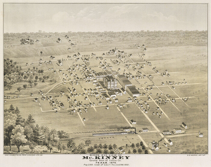
Bird's Eye View of McKinney, County Seat of Collin Co[unty], Texas
Print $20.00
Bird's Eye View of McKinney, County Seat of Collin Co[unty], Texas
1876
Size: 11.7 x 14.7 inches
89099
Bird's Eye View of New Braunfels, Comal County, Texas

Print $20.00
Bird's Eye View of New Braunfels, Comal County, Texas
1881
Size: 17.0 x 24.1 inches
89200
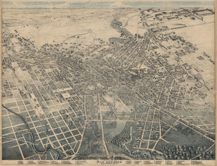
Bird's Eye View of San Antonio, Bexar Co[unty], Texas (Looking North East)
Print $20.00
Bird's Eye View of San Antonio, Bexar Co[unty], Texas (Looking North East)
1886
Size: 21.5 x 28.1 inches
89204
Bird's Eye View of San Marcos, Hays County, Texas

Print $20.00
Bird's Eye View of San Marcos, Hays County, Texas
1881
Size: 18.5 x 28.3 inches
89205
Bird's Eye View of Schulenburg, Fayette County, Texas

Print $20.00
Bird's Eye View of Schulenburg, Fayette County, Texas
1881
Size: 18.6 x 31.0 inches
89206
Bird's Eye View of Victoria

Print $20.00
Bird's Eye View of Victoria
1873
Size: 24.6 x 28.9 inches
89210
Bird's Eye View of the City of Austin, Travis County, Texas

Print $20.00
Bird's Eye View of the City of Austin, Travis County, Texas
1873
Size: 21.3 x 28.7 inches
89217
Bird's Eye View of the City of Belton, Bell County, Texas

Print $20.00
Bird's Eye View of the City of Belton, Bell County, Texas
1881
Size: 18.5 x 23.8 inches
89074
A Geological Map of the United States
Print $20.00
A Geological Map of the United States
-
Size
10.2 x 15.9 inches
-
Map/Doc
95281
A Geological Map of the United States and Canada
Print $20.00
A Geological Map of the United States and Canada
1853
-
Size
17.4 x 25.0 inches
-
Map/Doc
95189
-
Creation Date
1853
A Map of Austin's Colony and adjacent country in Texas drawn principally from actual survey by Stephen F. Austin
A Map of Austin's Colony and adjacent country in Texas drawn principally from actual survey by Stephen F. Austin
1820
-
Size
13.8 x 17.0 inches
-
Map/Doc
93353
-
Creation Date
1820
A Map of the United States of Mexico as organized and defined by the several Acts of the Congress of that Republic
Print $20.00
A Map of the United States of Mexico as organized and defined by the several Acts of the Congress of that Republic
1826
-
Size
23.2 x 28.9 inches
-
Map/Doc
93635
-
Creation Date
1826
A New Chart of the World on Mercator's Projection: Exhibiting the Tracks & Discoveries of the most Eminent Navigators, to the Present Period
Print $20.00
- Digital $50.00
A New Chart of the World on Mercator's Projection: Exhibiting the Tracks & Discoveries of the most Eminent Navigators, to the Present Period
1801
-
Size
20.0 x 22.4 inches
-
Map/Doc
97249
-
Creation Date
1801
A New Map of ye North Parts of America according to the division thereof by the Articles of Peace in 1763
Print $20.00
A New Map of ye North Parts of America according to the division thereof by the Articles of Peace in 1763
1763
-
Size
8.5 x 11.3 inches
-
Map/Doc
95280
-
Creation Date
1763
A general map of Great Britain and Ireland with part of Holland, Flanders, France & agreable to modern history
Print $20.00
A general map of Great Britain and Ireland with part of Holland, Flanders, France & agreable to modern history
1750
-
Size
21.6 x 25.7 inches
-
Map/Doc
97435
-
Creation Date
1750
Alvord, Texas

Print $20.00
Alvord, Texas
1890
-
Size
12.6 x 19.3 inches
-
Map/Doc
89072
-
Creation Date
1890
Amérique Septentrionale

Print $20.00
Amérique Septentrionale
1845
-
Size
13.8 x 20.3 inches
-
Map/Doc
94571
-
Creation Date
1845
Ashburn's Austin City Map

Ashburn's Austin City Map
1954
-
Size
22.4 x 17.4 inches
-
Map/Doc
93730
-
Creation Date
1954
Austin, State Capital of Texas
Print $20.00
Austin, State Capital of Texas
1887
-
Size
27.5 x 40.0 inches
-
Map/Doc
89218
-
Creation Date
1887
Bird's Eye View of Abilene, Taylor County, Texas
Print $20.00
Bird's Eye View of Abilene, Taylor County, Texas
1883
-
Size
23.6 x 30.7 inches
-
Map/Doc
89071
-
Creation Date
1883
Bird's Eye View of Bastrop, Bastrop County, Texas
Print $20.00
Bird's Eye View of Bastrop, Bastrop County, Texas
1887
-
Size
18.8 x 25.7 inches
-
Map/Doc
89073
-
Creation Date
1887
Bird's Eye View of Brenham, Washington County, Texas
Print $20.00
Bird's Eye View of Brenham, Washington County, Texas
1873
-
Size
20.0 x 25.7 inches
-
Map/Doc
89075
-
Creation Date
1873
Bird's Eye View of Corpus Christi
Print $20.00
Bird's Eye View of Corpus Christi
1887
-
Size
21.4 x 28.0 inches
-
Map/Doc
94113
-
Creation Date
1887
Bird's Eye View of Cuero, De Witt County, Texas
Print $20.00
Bird's Eye View of Cuero, De Witt County, Texas
1881
-
Size
18.4 x 25.5 inches
-
Map/Doc
89079
-
Creation Date
1881
Bird's Eye View of Gatesville, Coryell County, Texas
Print $20.00
Bird's Eye View of Gatesville, Coryell County, Texas
1884
-
Size
15.7 x 24.2 inches
-
Map/Doc
89088
-
Creation Date
1884
Bird's Eye View of Jefferson, Texas
Print $20.00
Bird's Eye View of Jefferson, Texas
1872
-
Size
18.7 x 23.5 inches
-
Map/Doc
89095
-
Creation Date
1872
Bird's Eye View of La Grange, Fayette County, Texas
Print $20.00
Bird's Eye View of La Grange, Fayette County, Texas
1880
-
Size
24.1 x 31.2 inches
-
Map/Doc
89096
-
Creation Date
1880
Bird's Eye View of McKinney, County Seat of Collin Co[unty], Texas
Print $20.00
Bird's Eye View of McKinney, County Seat of Collin Co[unty], Texas
1876
-
Size
11.7 x 14.7 inches
-
Map/Doc
89099
-
Creation Date
1876
Bird's Eye View of New Braunfels, Comal County, Texas
Print $20.00
Bird's Eye View of New Braunfels, Comal County, Texas
1881
-
Size
17.0 x 24.1 inches
-
Map/Doc
89200
-
Creation Date
1881
Bird's Eye View of San Antonio, Bexar Co[unty], Texas (Looking North East)
Print $20.00
Bird's Eye View of San Antonio, Bexar Co[unty], Texas (Looking North East)
1886
-
Size
21.5 x 28.1 inches
-
Map/Doc
89204
-
Creation Date
1886
Bird's Eye View of San Marcos, Hays County, Texas
Print $20.00
Bird's Eye View of San Marcos, Hays County, Texas
1881
-
Size
18.5 x 28.3 inches
-
Map/Doc
89205
-
Creation Date
1881
Bird's Eye View of Schulenburg, Fayette County, Texas
Print $20.00
Bird's Eye View of Schulenburg, Fayette County, Texas
1881
-
Size
18.6 x 31.0 inches
-
Map/Doc
89206
-
Creation Date
1881
Bird's Eye View of Victoria
Print $20.00
Bird's Eye View of Victoria
1873
-
Size
24.6 x 28.9 inches
-
Map/Doc
89210
-
Creation Date
1873
Bird's Eye View of the City of Austin, Travis County, Texas
Print $20.00
Bird's Eye View of the City of Austin, Travis County, Texas
1873
-
Size
21.3 x 28.7 inches
-
Map/Doc
89217
-
Creation Date
1873
Bird's Eye View of the City of Belton, Bell County, Texas
Print $20.00
Bird's Eye View of the City of Belton, Bell County, Texas
1881
-
Size
18.5 x 23.8 inches
-
Map/Doc
89074
-
Creation Date
1881