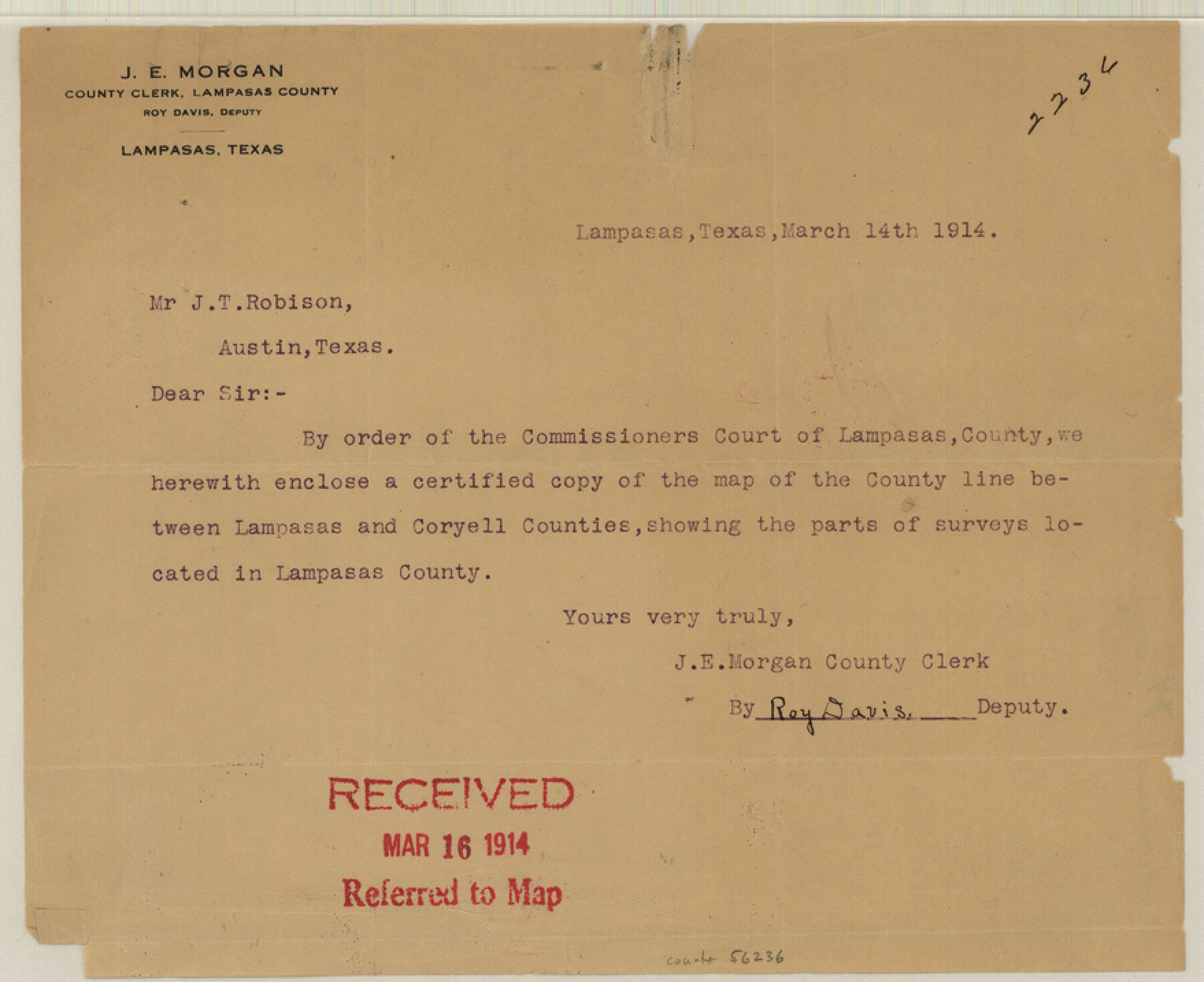
Lampasas County Boundary File 17
Coryell and Lampasas Bndry Line
-
Map/Doc
56236
-
Collection
General Map Collection
-
Counties
Lampasas
-
Subjects
County Boundaries
-
Height x Width
7.2 x 8.8 inches
18.3 x 22.4 cm
Part of: General Map Collection

Morris County Rolled Sketch 2A

Print $20.00
- Digital $50.00
Morris County Rolled Sketch 2A
Size 24.0 x 18.8 inches
Map/Doc 10275
Nolan County Sketch File B

Print $20.00
- Digital $50.00
Nolan County Sketch File B
1902
Size 12.0 x 21.5 inches
Map/Doc 42171
Atascosa County Sketch File 42

Print $12.00
- Digital $50.00
Atascosa County Sketch File 42
1916
Size 11.2 x 8.8 inches
Map/Doc 13847
Borden County Working Sketch 16

Print $40.00
- Digital $50.00
Borden County Working Sketch 16
2007
Size 48.0 x 29.4 inches
Map/Doc 87206
[Cotton Belt, St. Louis Southwestern Railway of Texas, Alignment through Smith County]
![64375, [Cotton Belt, St. Louis Southwestern Railway of Texas, Alignment through Smith County], General Map Collection](https://historictexasmaps.com/wmedia_w700/maps/64375.tif.jpg)
Print $20.00
- Digital $50.00
[Cotton Belt, St. Louis Southwestern Railway of Texas, Alignment through Smith County]
1903
Size 21.3 x 28.5 inches
Map/Doc 64375
Brazos River, Brazos River Sheet 1

Print $20.00
- Digital $50.00
Brazos River, Brazos River Sheet 1
1926
Size 20.7 x 25.3 inches
Map/Doc 69665
Fayette County Sketch File 5

Print $4.00
- Digital $50.00
Fayette County Sketch File 5
Size 14.3 x 8.7 inches
Map/Doc 22506
Cherokee County Sketch File 5

Print $12.00
- Digital $50.00
Cherokee County Sketch File 5
1852
Size 12.4 x 8.6 inches
Map/Doc 18120
Jackson County Aerial Photograph Index Sheet 7

Print $20.00
- Digital $50.00
Jackson County Aerial Photograph Index Sheet 7
1956
Size 21.2 x 15.8 inches
Map/Doc 83706
Dimmit County Sketch File 27

Print $20.00
- Digital $50.00
Dimmit County Sketch File 27
Size 16.5 x 18.3 inches
Map/Doc 11349
Right of Way and Track Map, International & Gt. Northern Ry. Operated by the International & Gt. Northern Ry. Co., Gulf Division

Print $40.00
- Digital $50.00
Right of Way and Track Map, International & Gt. Northern Ry. Operated by the International & Gt. Northern Ry. Co., Gulf Division
1917
Size 24.8 x 57.0 inches
Map/Doc 64245
You may also like
Castro County Sketch File 4g

Print $4.00
- Digital $50.00
Castro County Sketch File 4g
Size 12.0 x 8.9 inches
Map/Doc 17477
Brazos River, Ball Hill Sheet/Big Creek

Print $6.00
- Digital $50.00
Brazos River, Ball Hill Sheet/Big Creek
1926
Size 34.3 x 30.0 inches
Map/Doc 65281
Flight Mission No. BRA-7M, Frame 24, Jefferson County

Print $20.00
- Digital $50.00
Flight Mission No. BRA-7M, Frame 24, Jefferson County
1953
Size 18.6 x 22.3 inches
Map/Doc 85475
Bosque County Sketch File 21

Print $12.00
- Digital $50.00
Bosque County Sketch File 21
1863
Size 10.9 x 8.7 inches
Map/Doc 14798
Harris County Boundary File 39 (15)

Print $8.00
- Digital $50.00
Harris County Boundary File 39 (15)
Size 7.2 x 8.3 inches
Map/Doc 54350
Aransas County NRC Article 33.136 Sketch 10

Print $26.00
- Digital $50.00
Aransas County NRC Article 33.136 Sketch 10
Size 24.2 x 36.0 inches
Map/Doc 95016
Brewster County Sketch File A

Print $40.00
- Digital $50.00
Brewster County Sketch File A
1910
Size 18.6 x 19.9 inches
Map/Doc 10974
Wheelock Second Addition

Print $20.00
- Digital $50.00
Wheelock Second Addition
1952
Size 9.3 x 24.3 inches
Map/Doc 92308
Harris County Working Sketch 58

Print $20.00
- Digital $50.00
Harris County Working Sketch 58
1952
Size 24.1 x 26.5 inches
Map/Doc 65950
Dimmit County Sketch File 13

Print $46.00
- Digital $50.00
Dimmit County Sketch File 13
1884
Size 22.6 x 36.5 inches
Map/Doc 11341
Flight Mission No. CRE-2R, Frame 169, Jackson County

Print $20.00
- Digital $50.00
Flight Mission No. CRE-2R, Frame 169, Jackson County
1956
Size 18.6 x 22.3 inches
Map/Doc 85379
Bee County Sketch File 26

Print $6.00
- Digital $50.00
Bee County Sketch File 26
1883
Size 14.5 x 9.0 inches
Map/Doc 14328