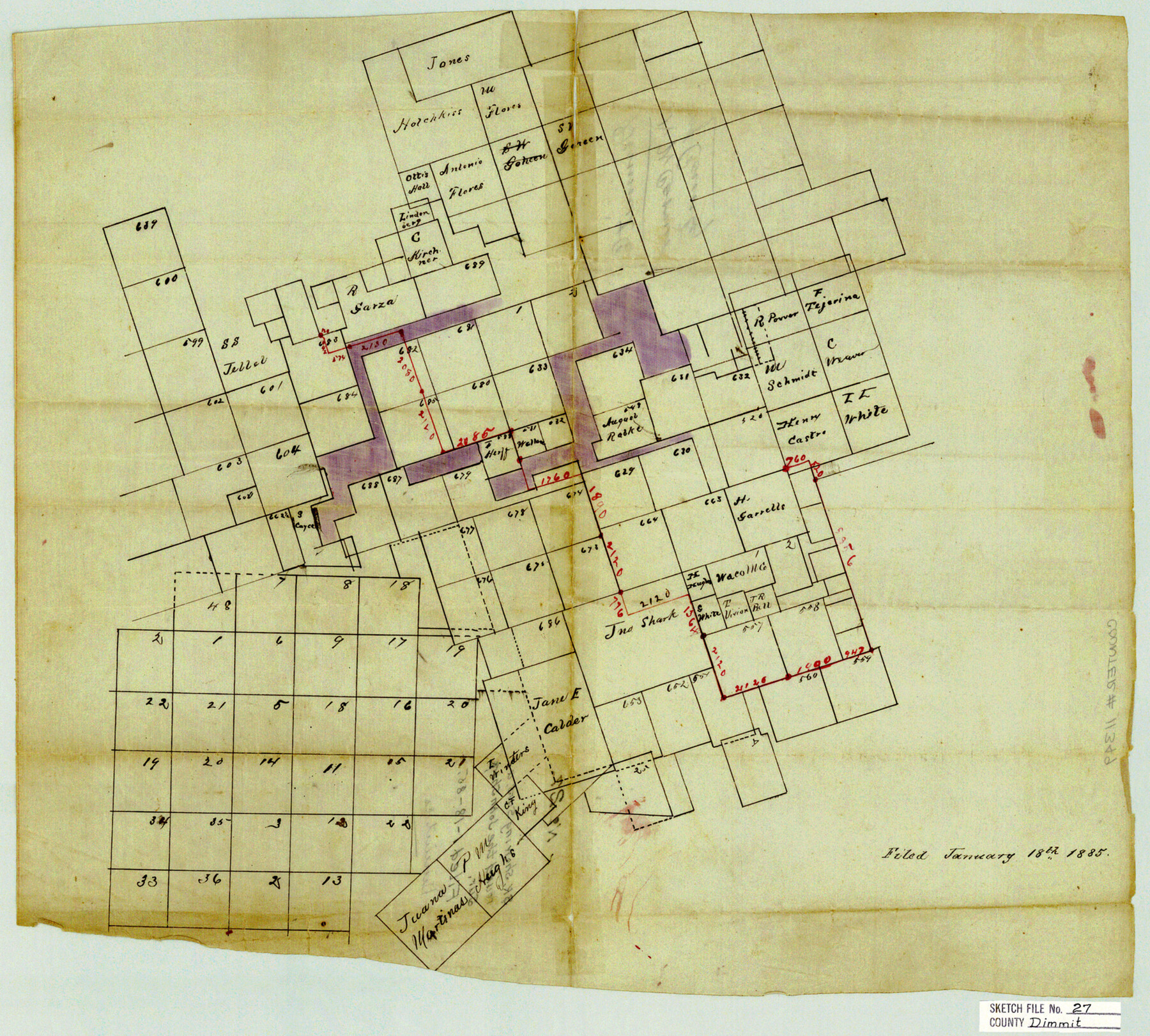
Dimmit County Sketch File 27
Sketch showing surveys around the John Sharp survey
-
Map/Doc
11349
-
Collection
General Map Collection
-
Object Dates
1885/1/18 (File Date)
-
Counties
Dimmit Zavala
-
Subjects
Surveying Sketch File
-
Height x Width
16.5 x 18.3 inches
41.9 x 46.5 cm
-
Medium
paper, manuscript
-
Comments
Now filed in Flattened Sketch Files. Also bears W 10 miles from Crystal City, the county seat of Zavala County.
Part of: General Map Collection
Mason County Rolled Sketch 3

Print $20.00
- Digital $50.00
Mason County Rolled Sketch 3
1965
Size 30.3 x 22.8 inches
Map/Doc 6676
Culberson County Working Sketch 73

Print $40.00
- Digital $50.00
Culberson County Working Sketch 73
1975
Size 48.7 x 33.4 inches
Map/Doc 68527
Starr County Boundary File 1a

Print $20.00
- Digital $50.00
Starr County Boundary File 1a
Size 22.4 x 41.0 inches
Map/Doc 58813
[Location Survey of the Southern Kansas Railway, Kiowa Extension from a point in Drake's Location, in Indian Territory 100 miles from south line of Kansas, continuing up Wolf Creek and South Canadian River to Cottonwood Creek in Hutchinson County]
![88842, [Location Survey of the Southern Kansas Railway, Kiowa Extension from a point in Drake's Location, in Indian Territory 100 miles from south line of Kansas, continuing up Wolf Creek and South Canadian River to Cottonwood Creek in Hutchinson County], General Map Collection](https://historictexasmaps.com/wmedia_w700/maps/88842.tif.jpg)
Print $20.00
- Digital $50.00
[Location Survey of the Southern Kansas Railway, Kiowa Extension from a point in Drake's Location, in Indian Territory 100 miles from south line of Kansas, continuing up Wolf Creek and South Canadian River to Cottonwood Creek in Hutchinson County]
1886
Size 39.0 x 42.0 inches
Map/Doc 88842
Map of Kerr County Texas

Print $20.00
- Digital $50.00
Map of Kerr County Texas
1879
Size 20.3 x 28.3 inches
Map/Doc 3763
Cuadro Historico-Geroglifico de la Peregrinacion de las Tribus Aztecas que Poblaron el Valle de Mexico (Num. 1)

Print $20.00
- Digital $50.00
Cuadro Historico-Geroglifico de la Peregrinacion de las Tribus Aztecas que Poblaron el Valle de Mexico (Num. 1)
Size 22.9 x 31.2 inches
Map/Doc 97013
[Surveys in Vehlein's Colony along Long King's Creek]
![83, [Surveys in Vehlein's Colony along Long King's Creek], General Map Collection](https://historictexasmaps.com/wmedia_w700/maps/83.tif.jpg)
Print $20.00
- Digital $50.00
[Surveys in Vehlein's Colony along Long King's Creek]
Size 13.3 x 19.0 inches
Map/Doc 83
Brewster County Sketch File 54

Print $4.00
- Digital $50.00
Brewster County Sketch File 54
1963
Size 11.0 x 8.5 inches
Map/Doc 16383
[Beaumont, Sour Lake and Western Ry. Right of Way and Alignment - Frisco]
![64123, [Beaumont, Sour Lake and Western Ry. Right of Way and Alignment - Frisco], General Map Collection](https://historictexasmaps.com/wmedia_w700/maps/64123.tif.jpg)
Print $20.00
- Digital $50.00
[Beaumont, Sour Lake and Western Ry. Right of Way and Alignment - Frisco]
1910
Size 20.4 x 46.2 inches
Map/Doc 64123
Flight Mission No. CUG-3P, Frame 142, Kleberg County

Print $20.00
- Digital $50.00
Flight Mission No. CUG-3P, Frame 142, Kleberg County
1956
Size 18.7 x 22.3 inches
Map/Doc 86277
Culberson County Rolled Sketch SL

Print $20.00
- Digital $50.00
Culberson County Rolled Sketch SL
1930
Size 19.1 x 24.7 inches
Map/Doc 5683
Flight Mission No. CRC-4R, Frame 95, Chambers County

Print $20.00
- Digital $50.00
Flight Mission No. CRC-4R, Frame 95, Chambers County
1956
Size 18.6 x 22.3 inches
Map/Doc 84892
You may also like
Bahia de S. Bernardo

Print $20.00
- Digital $50.00
Bahia de S. Bernardo
1809
Size 17.0 x 25.2 inches
Map/Doc 95142
General Highway Map, Angelina County, Texas

Print $20.00
General Highway Map, Angelina County, Texas
1940
Size 18.5 x 24.9 inches
Map/Doc 79003
Blanco County Working Sketch 10

Print $20.00
- Digital $50.00
Blanco County Working Sketch 10
1938
Size 28.3 x 25.8 inches
Map/Doc 67370
Flight Mission No. CUG-1P, Frame 43, Kleberg County

Print $20.00
- Digital $50.00
Flight Mission No. CUG-1P, Frame 43, Kleberg County
1956
Size 18.6 x 22.4 inches
Map/Doc 86121
Terrell County Working Sketch 33

Print $20.00
- Digital $50.00
Terrell County Working Sketch 33
1945
Size 16.1 x 31.6 inches
Map/Doc 62125
Jefferson County Sketch File 11

Print $6.00
- Digital $50.00
Jefferson County Sketch File 11
1862
Size 8.0 x 6.4 inches
Map/Doc 28132
Starr County Sketch File 7

Print $20.00
- Digital $50.00
Starr County Sketch File 7
Size 25.4 x 20.8 inches
Map/Doc 12326
Flight Mission No. DCL-6C, Frame 65, Kenedy County

Print $20.00
- Digital $50.00
Flight Mission No. DCL-6C, Frame 65, Kenedy County
1943
Size 18.5 x 22.3 inches
Map/Doc 85907
Karnes County Working Sketch 6

Print $20.00
- Digital $50.00
Karnes County Working Sketch 6
1961
Size 23.3 x 27.5 inches
Map/Doc 66654
Brown County Working Sketch 12

Print $20.00
- Digital $50.00
Brown County Working Sketch 12
1984
Size 27.0 x 25.2 inches
Map/Doc 67777
Val Verde County Sketch File 19

Print $4.00
- Digital $50.00
Val Verde County Sketch File 19
1858
Size 13.0 x 8.1 inches
Map/Doc 39229
Terrell County Rolled Sketch 47

Print $20.00
- Digital $50.00
Terrell County Rolled Sketch 47
1958
Size 20.0 x 18.4 inches
Map/Doc 7949