Morris County Rolled Sketch 2A
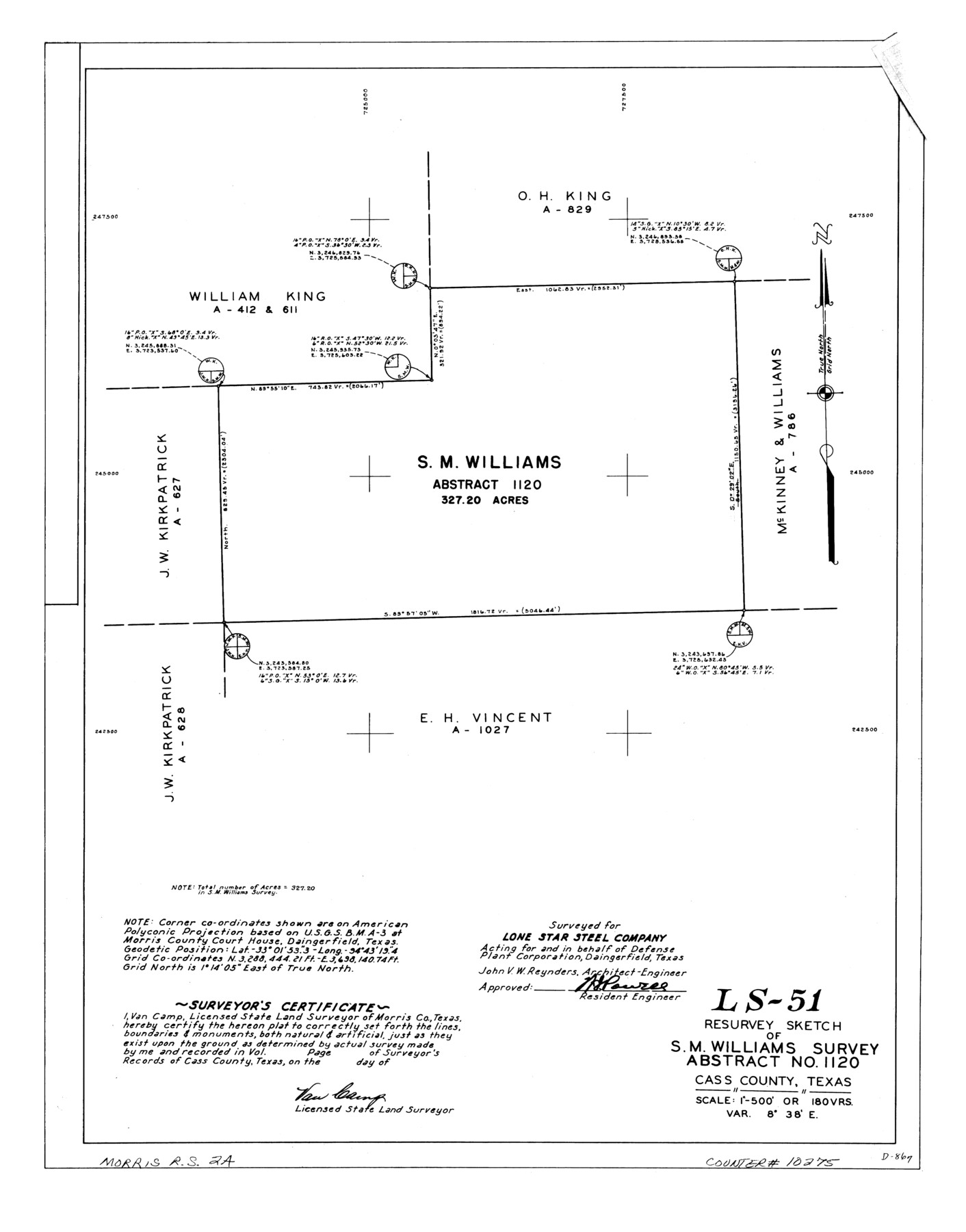
LS-51 - Resurvey sketch of S.M. Williams survey, abstract no. 1120, Cass County, Texas
-
Map/Doc
10275
-
Collection
General Map Collection
-
People and Organizations
Van Camp (Surveyor/Engineer)
-
Counties
Cass
-
Subjects
Surveying Rolled Sketch
-
Height x Width
24.0 x 18.8 inches
61.0 x 47.8 cm
-
Medium
linen, manuscript
-
Scale
1" = 180 varas
-
Comments
See Morris County Rolled Sketch 2 (9550) for map of all retracement surveys made for Lone Star Steel Company.
Related maps
Morris County Rolled Sketch 2

Print $40.00
- Digital $50.00
Morris County Rolled Sketch 2
1944
Size 59.4 x 43.5 inches
Map/Doc 9550
Part of: General Map Collection
Galveston County Working Sketch 8

Print $20.00
- Digital $50.00
Galveston County Working Sketch 8
1939
Size 43.4 x 39.6 inches
Map/Doc 69345
Galveston County Sketch File 49

Print $2.00
- Digital $50.00
Galveston County Sketch File 49
Size 5.5 x 8.6 inches
Map/Doc 23480
Scurry County Working Sketch 2

Print $3.00
- Digital $50.00
Scurry County Working Sketch 2
1934
Size 16.2 x 10.2 inches
Map/Doc 63831
Crane County Working Sketch 31

Print $20.00
- Digital $50.00
Crane County Working Sketch 31
1982
Size 34.3 x 37.7 inches
Map/Doc 68308
Hamilton County Working Sketch 2

Print $20.00
- Digital $50.00
Hamilton County Working Sketch 2
1923
Size 12.9 x 15.7 inches
Map/Doc 63340
Armstrong County Sketch File 4

Print $40.00
- Digital $50.00
Armstrong County Sketch File 4
1887
Size 17.9 x 20.1 inches
Map/Doc 10840
Sutton County Working Sketch 67

Print $20.00
- Digital $50.00
Sutton County Working Sketch 67
1972
Size 37.7 x 36.7 inches
Map/Doc 62410
Working Sketch of Central State Prison Farm, Fort Bend Co., Texas

Print $20.00
- Digital $50.00
Working Sketch of Central State Prison Farm, Fort Bend Co., Texas
Size 38.9 x 16.0 inches
Map/Doc 62996
[Sketch for Mineral Application 31137 - Colorado River, W. A. Wagner]
![65634, [Sketch for Mineral Application 31137 - Colorado River, W. A. Wagner], General Map Collection](https://historictexasmaps.com/wmedia_w700/maps/65634.tif.jpg)
Print $40.00
- Digital $50.00
[Sketch for Mineral Application 31137 - Colorado River, W. A. Wagner]
1928
Size 39.6 x 126.2 inches
Map/Doc 65634
Travis County Working Sketch 64

Print $20.00
- Digital $50.00
Travis County Working Sketch 64
2000
Size 16.8 x 19.6 inches
Map/Doc 69448
Moore County Working Sketch 16

Print $20.00
- Digital $50.00
Moore County Working Sketch 16
1981
Size 26.3 x 23.2 inches
Map/Doc 71198
Swisher County Sketch File 2

Print $8.00
- Digital $50.00
Swisher County Sketch File 2
1891
Size 14.3 x 8.6 inches
Map/Doc 37574
You may also like
Chicago, Rock Island, Texas & Mexico

Print $20.00
- Digital $50.00
Chicago, Rock Island, Texas & Mexico
1920
Size 23.9 x 13.8 inches
Map/Doc 64423
Concho County Sketch File 23

Print $6.00
- Digital $50.00
Concho County Sketch File 23
Size 11.0 x 7.3 inches
Map/Doc 19146
Medina County

Print $40.00
- Digital $50.00
Medina County
1976
Size 52.5 x 43.2 inches
Map/Doc 73237
Jackson County Sketch File 11

Print $20.00
- Digital $50.00
Jackson County Sketch File 11
1922
Size 15.7 x 30.1 inches
Map/Doc 11837
Loving County State of Texas

Print $20.00
- Digital $50.00
Loving County State of Texas
1889
Size 20.5 x 24.5 inches
Map/Doc 4581
Anderson County Working Sketch 30

Print $20.00
- Digital $50.00
Anderson County Working Sketch 30
1963
Size 29.8 x 41.6 inches
Map/Doc 67030
[I. M. Bolton, L. S. Thacker, and R. C. Poteet Subdivisions]
![92578, [I. M. Bolton, L. S. Thacker, and R. C. Poteet Subdivisions], Twichell Survey Records](https://historictexasmaps.com/wmedia_w700/maps/92578-1.tif.jpg)
Print $20.00
- Digital $50.00
[I. M. Bolton, L. S. Thacker, and R. C. Poteet Subdivisions]
1924
Size 18.7 x 24.7 inches
Map/Doc 92578
[G.C. and S. F. R.R. Co. Through Bosque County from McLennan Co. and E. to Hill Co. Station M. P. 259 to M. P. 297]
![64563, [G.C. and S. F. R.R. Co. Through Bosque County from McLennan Co. and E. to Hill Co. Station M. P. 259 to M. P. 297], General Map Collection](https://historictexasmaps.com/wmedia_w700/maps/64563-1.tif.jpg)
Print $40.00
- Digital $50.00
[G.C. and S. F. R.R. Co. Through Bosque County from McLennan Co. and E. to Hill Co. Station M. P. 259 to M. P. 297]
Size 21.7 x 120.5 inches
Map/Doc 64563
Bee County Sketch File 11

Print $40.00
- Digital $50.00
Bee County Sketch File 11
Size 20.8 x 25.0 inches
Map/Doc 10915
Flight Mission No. CLL-3N, Frame 5, Willacy County

Print $20.00
- Digital $50.00
Flight Mission No. CLL-3N, Frame 5, Willacy County
1954
Size 18.4 x 22.1 inches
Map/Doc 87071
Hill County Sketch File 17

Print $4.00
- Digital $50.00
Hill County Sketch File 17
1860
Size 12.5 x 8.3 inches
Map/Doc 26484
Brewster County Working Sketch 77

Print $20.00
- Digital $50.00
Brewster County Working Sketch 77
1968
Size 25.0 x 20.9 inches
Map/Doc 67677