[Surveys on the Rio Frio]
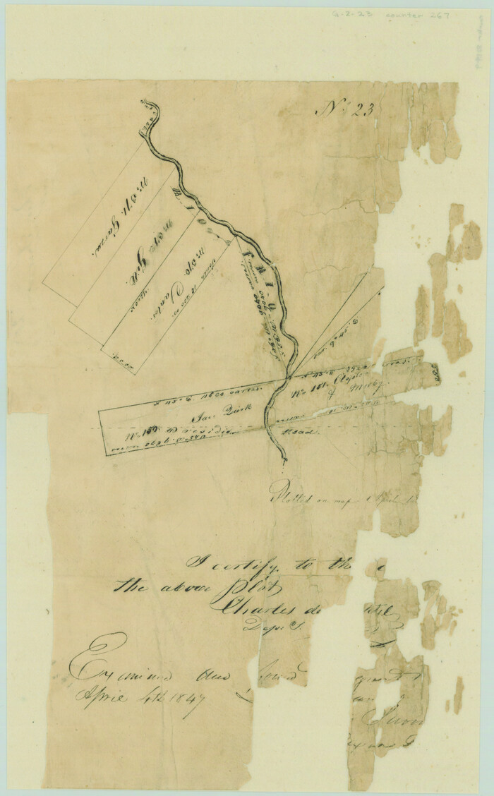
Print $2.00
- Digital $50.00
[Surveys on the Rio Frio]
1847
Size: 11.8 x 7.3 inches
267
[Surveys in the Bexar District along the Sabinal and Frio Rivers]
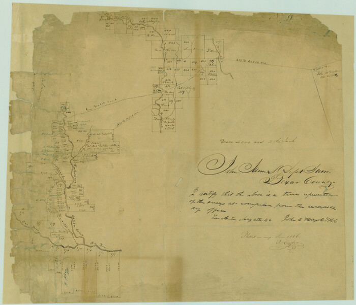
Print $20.00
- Digital $50.00
[Surveys in the Bexar District along the Sabinal and Frio Rivers]
1846
Size: 16.8 x 19.6 inches
3167
[Surveys in the Bexar District along the Medina River]
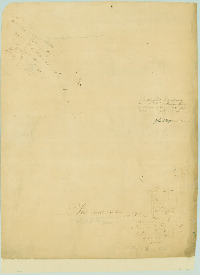
Print $20.00
- Digital $50.00
[Surveys in the Bexar District along the Medina River]
1841
Size: 23.0 x 16.8 inches
128
[Surveys in the Bexar District along the Frio and Leona Rivers]
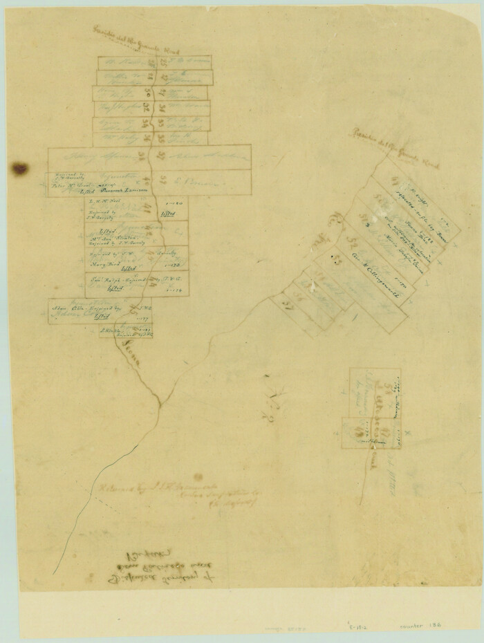
Print $20.00
- Digital $50.00
[Surveys in the Bexar District along the Frio and Leona Rivers]
1842
Size: 16.2 x 12.2 inches
136
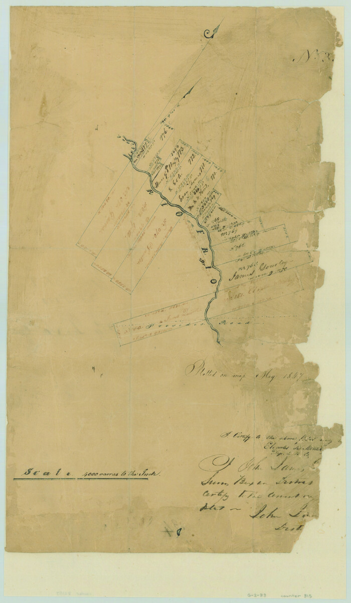
[Surveys in the Bexar District along the Frio River]
Print $2.00
- Digital $50.00
[Surveys in the Bexar District along the Frio River]
1847
Size: 15.8 x 9.2 inches
315
[Surveys in the Bexar District along Hondo and Seco Creeks]
Print $3.00
- Digital $50.00
[Surveys in the Bexar District along Hondo and Seco Creeks]
1847
Size: 9.3 x 9.9 inches
314
[Surveys along the Leona and Frio Rivers]
Print $20.00
- Digital $50.00
[Surveys along the Leona and Frio Rivers]
1841
Size: 12.4 x 13.1 inches
16
[Surveys along the Frio River]
Print $20.00
- Digital $50.00
[Surveys along the Frio River]
1841
Size: 12.0 x 16.6 inches
129
Zavala County Sketch File 43

Print $20.00
- Digital $50.00
Zavala County Sketch File 43
1915
Size: 26.8 x 32.4 inches
12733
Zavala County Sketch File 11a

Print $10.00
- Digital $50.00
Zavala County Sketch File 11a
1885
Size: 11.2 x 8.6 inches
41272
Zavala County Sketch File 11

Print $4.00
- Digital $50.00
Zavala County Sketch File 11
1885
Size: 14.4 x 8.8 inches
41270
Zavala County Sketch File 10a

Print $6.00
- Digital $50.00
Zavala County Sketch File 10a
1885
Size: 14.6 x 8.8 inches
41267
Zavala County Sketch File 1

Print $20.00
- Digital $50.00
Zavala County Sketch File 1
Size: 28.5 x 22.7 inches
12725
Zavala County Rolled Sketch 24

Print $20.00
- Digital $50.00
Zavala County Rolled Sketch 24
1945
Size: 21.7 x 18.2 inches
8327
Zavala County Rolled Sketch 21

Print $20.00
- Digital $50.00
Zavala County Rolled Sketch 21
Size: 27.6 x 38.4 inches
8324
Zavala County Rolled Sketch 14

Print $20.00
- Digital $50.00
Zavala County Rolled Sketch 14
1887
Size: 28.1 x 40.8 inches
10175
Surveyor's Watercourse Report 2

Print $42.00
Surveyor's Watercourse Report 2
2025
Size: 11.0 x 8.5 inches
97512
Medina County Working Sketch 5

Print $20.00
- Digital $50.00
Medina County Working Sketch 5
1949
Size: 38.5 x 37.3 inches
70920
Medina County Sketch File 21

Print $38.00
- Digital $50.00
Medina County Sketch File 21
2002
Size: 11.2 x 8.7 inches
76343
Medina County Sketch File 16

Print $8.00
- Digital $50.00
Medina County Sketch File 16
1948
Size: 11.4 x 8.8 inches
31476
Medina County Sketch File 14

Print $24.00
- Digital $50.00
Medina County Sketch File 14
1914
Size: 10.6 x 7.0 inches
31471
Medina County Sketch File 1

Print $4.00
- Digital $50.00
Medina County Sketch File 1
Size: 12.5 x 8.1 inches
31437
Medina County Rolled Sketch 5

Print $40.00
- Digital $50.00
Medina County Rolled Sketch 5
1948
Size: 52.0 x 47.1 inches
9505
Medina County Rolled Sketch 21

Print $20.00
- Digital $50.00
Medina County Rolled Sketch 21
2002
Size: 33.5 x 19.1 inches
76412
Medina County Rolled Sketch 19

Print $40.00
- Digital $50.00
Medina County Rolled Sketch 19
1987
Size: 45.1 x 57.8 inches
9508
Map representing the surveys made in Bexar County

Print $40.00
- Digital $50.00
Map representing the surveys made in Bexar County
1839
Size: 76.0 x 68.4 inches
1947
Map representing the surveys made in Bexar County

Print $40.00
- Digital $50.00
Map representing the surveys made in Bexar County
1839
Size: 75.7 x 37.9 inches
93364
Map representing the surveys made in Bexar County

Print $40.00
- Digital $50.00
Map representing the surveys made in Bexar County
1839
Size: 75.7 x 35.1 inches
93365
Map of Frio County, Texas

Print $20.00
- Digital $50.00
Map of Frio County, Texas
1879
Size: 24.1 x 22.5 inches
5032
[Surveys on the Rio Frio]
Print $2.00
- Digital $50.00
[Surveys on the Rio Frio]
1847
-
Size
11.8 x 7.3 inches
-
Map/Doc
267
-
Creation Date
1847
[Surveys in the Bexar District along the Sabinal and Frio Rivers]
Print $20.00
- Digital $50.00
[Surveys in the Bexar District along the Sabinal and Frio Rivers]
1846
-
Size
16.8 x 19.6 inches
-
Map/Doc
3167
-
Creation Date
1846
[Surveys in the Bexar District along the Medina River]
Print $20.00
- Digital $50.00
[Surveys in the Bexar District along the Medina River]
1841
-
Size
23.0 x 16.8 inches
-
Map/Doc
128
-
Creation Date
1841
[Surveys in the Bexar District along the Frio and Leona Rivers]
Print $20.00
- Digital $50.00
[Surveys in the Bexar District along the Frio and Leona Rivers]
1842
-
Size
16.2 x 12.2 inches
-
Map/Doc
136
-
Creation Date
1842
[Surveys in the Bexar District along the Frio River]
Print $2.00
- Digital $50.00
[Surveys in the Bexar District along the Frio River]
1847
-
Size
15.8 x 9.2 inches
-
Map/Doc
315
-
Creation Date
1847
[Surveys in the Bexar District along Hondo and Seco Creeks]
Print $3.00
- Digital $50.00
[Surveys in the Bexar District along Hondo and Seco Creeks]
1847
-
Size
9.3 x 9.9 inches
-
Map/Doc
314
-
Creation Date
1847
[Surveys along the Leona and Frio Rivers]
Print $20.00
- Digital $50.00
[Surveys along the Leona and Frio Rivers]
1841
-
Size
12.4 x 13.1 inches
-
Map/Doc
16
-
Creation Date
1841
[Surveys along the Frio River]
Print $20.00
- Digital $50.00
[Surveys along the Frio River]
1841
-
Size
12.0 x 16.6 inches
-
Map/Doc
129
-
Creation Date
1841
Zavala County Sketch File 43
Print $20.00
- Digital $50.00
Zavala County Sketch File 43
1915
-
Size
26.8 x 32.4 inches
-
Map/Doc
12733
-
Creation Date
1915
Zavala County Sketch File 11a
Print $10.00
- Digital $50.00
Zavala County Sketch File 11a
1885
-
Size
11.2 x 8.6 inches
-
Map/Doc
41272
-
Creation Date
1885
Zavala County Sketch File 11
Print $4.00
- Digital $50.00
Zavala County Sketch File 11
1885
-
Size
14.4 x 8.8 inches
-
Map/Doc
41270
-
Creation Date
1885
Zavala County Sketch File 10a
Print $6.00
- Digital $50.00
Zavala County Sketch File 10a
1885
-
Size
14.6 x 8.8 inches
-
Map/Doc
41267
-
Creation Date
1885
Zavala County Sketch File 1
Print $20.00
- Digital $50.00
Zavala County Sketch File 1
-
Size
28.5 x 22.7 inches
-
Map/Doc
12725
Zavala County Rolled Sketch 24
Print $20.00
- Digital $50.00
Zavala County Rolled Sketch 24
1945
-
Size
21.7 x 18.2 inches
-
Map/Doc
8327
-
Creation Date
1945
Zavala County Rolled Sketch 21
Print $20.00
- Digital $50.00
Zavala County Rolled Sketch 21
-
Size
27.6 x 38.4 inches
-
Map/Doc
8324
Zavala County Rolled Sketch 14
Print $20.00
- Digital $50.00
Zavala County Rolled Sketch 14
1887
-
Size
28.1 x 40.8 inches
-
Map/Doc
10175
-
Creation Date
1887
Texas Hill Country Trail Region

Texas Hill Country Trail Region
2017
-
Size
18.2 x 24.3 inches
-
Map/Doc
96871
-
Creation Date
2017
Surveyor's Watercourse Report 2
Print $42.00
Surveyor's Watercourse Report 2
2025
-
Size
11.0 x 8.5 inches
-
Map/Doc
97512
-
Creation Date
2025
Medina County Working Sketch 5
Print $20.00
- Digital $50.00
Medina County Working Sketch 5
1949
-
Size
38.5 x 37.3 inches
-
Map/Doc
70920
-
Creation Date
1949
Medina County Sketch File 21
Print $38.00
- Digital $50.00
Medina County Sketch File 21
2002
-
Size
11.2 x 8.7 inches
-
Map/Doc
76343
-
Creation Date
2002
Medina County Sketch File 16
Print $8.00
- Digital $50.00
Medina County Sketch File 16
1948
-
Size
11.4 x 8.8 inches
-
Map/Doc
31476
-
Creation Date
1948
Medina County Sketch File 14
Print $24.00
- Digital $50.00
Medina County Sketch File 14
1914
-
Size
10.6 x 7.0 inches
-
Map/Doc
31471
-
Creation Date
1914
Medina County Sketch File 1
Print $4.00
- Digital $50.00
Medina County Sketch File 1
-
Size
12.5 x 8.1 inches
-
Map/Doc
31437
Medina County Rolled Sketch 5
Print $40.00
- Digital $50.00
Medina County Rolled Sketch 5
1948
-
Size
52.0 x 47.1 inches
-
Map/Doc
9505
-
Creation Date
1948
Medina County Rolled Sketch 21
Print $20.00
- Digital $50.00
Medina County Rolled Sketch 21
2002
-
Size
33.5 x 19.1 inches
-
Map/Doc
76412
-
Creation Date
2002
Medina County Rolled Sketch 19
Print $40.00
- Digital $50.00
Medina County Rolled Sketch 19
1987
-
Size
45.1 x 57.8 inches
-
Map/Doc
9508
-
Creation Date
1987
Map representing the surveys made in Bexar County
Print $40.00
- Digital $50.00
Map representing the surveys made in Bexar County
1839
-
Size
76.0 x 68.4 inches
-
Map/Doc
1947
-
Creation Date
1839
Map representing the surveys made in Bexar County
Print $40.00
- Digital $50.00
Map representing the surveys made in Bexar County
1839
-
Size
75.7 x 37.9 inches
-
Map/Doc
93364
-
Creation Date
1839
Map representing the surveys made in Bexar County
Print $40.00
- Digital $50.00
Map representing the surveys made in Bexar County
1839
-
Size
75.7 x 35.1 inches
-
Map/Doc
93365
-
Creation Date
1839
Map of Frio County, Texas
Print $20.00
- Digital $50.00
Map of Frio County, Texas
1879
-
Size
24.1 x 22.5 inches
-
Map/Doc
5032
-
Creation Date
1879