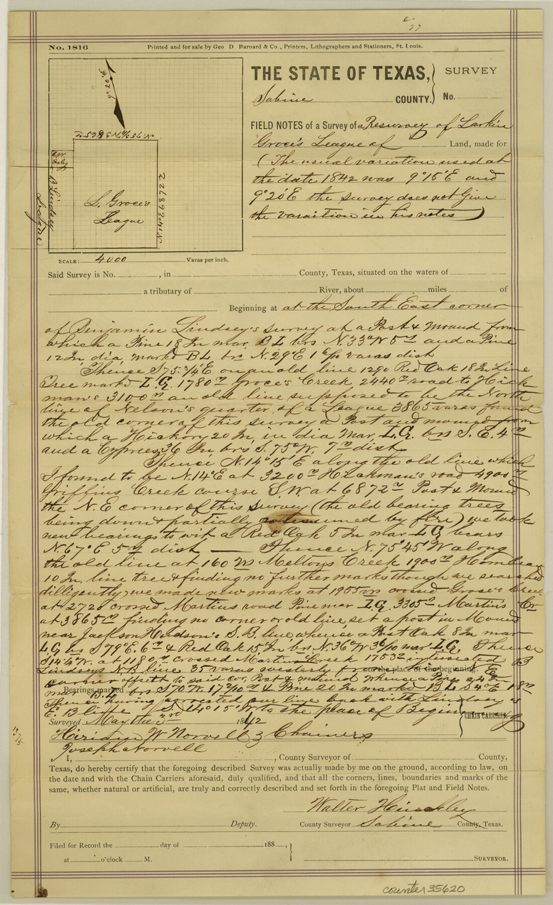
Sabine County Sketch File 7a
[True copy of the field notes of a resurvey of Larkin Groce's league]
-
Map/Doc
35620
-
Collection
General Map Collection
-
Object Dates
9/26/1882 (Creation Date)
12/9/1882 (File Date)
5/3/1842 (Survey Date)
-
People and Organizations
John F. Hankla (Surveyor/Engineer)
Walter Hinckley (Surveyor/Engineer)
Hiriam W. Norvell (Chainman/Field Personnel)
Joseph Norvell (Chainman/Field Personnel)
-
Counties
Sabine
-
Subjects
Surveying Sketch File
-
Height x Width
14.2 x 8.7 inches
36.1 x 22.1 cm
-
Medium
paper, print with manuscript additions
-
Features
Groce's Creek
Road to Hickman
Griffin's Creek
Melton's Creek
Martin's Road
Martin's Creek
Part of: General Map Collection

Smith County Working Sketch 1

Print $20.00
- Digital $50.00
Smith County Working Sketch 1
Size 16.3 x 13.0 inches
Map/Doc 63886
Zavala County Sketch File 19

Print $6.00
- Digital $50.00
Zavala County Sketch File 19
1909
Size 5.6 x 8.8 inches
Map/Doc 41371
Texas Intracoastal Waterway - Port O'Connor to San Antonio Bay, Including Pass Cavallo

Print $20.00
- Digital $50.00
Texas Intracoastal Waterway - Port O'Connor to San Antonio Bay, Including Pass Cavallo
1961
Size 26.5 x 38.7 inches
Map/Doc 73373
Llano County Sketch File 16

Print $12.00
- Digital $50.00
Llano County Sketch File 16
1905
Size 12.3 x 11.3 inches
Map/Doc 30392
Jackson County Sketch File 21

Print $70.00
- Digital $50.00
Jackson County Sketch File 21
2000
Size 11.3 x 8.8 inches
Map/Doc 27673
Flight Mission No. DQN-1K, Frame 106, Calhoun County

Print $20.00
- Digital $50.00
Flight Mission No. DQN-1K, Frame 106, Calhoun County
1953
Size 18.8 x 22.3 inches
Map/Doc 84173
Flight Mission No. BRA-7M, Frame 41, Jefferson County

Print $20.00
- Digital $50.00
Flight Mission No. BRA-7M, Frame 41, Jefferson County
1953
Size 18.6 x 22.3 inches
Map/Doc 85492
Fayette County Sketch File 6

Print $114.00
- Digital $50.00
Fayette County Sketch File 6
1981
Size 14.9 x 9.5 inches
Map/Doc 22508
Flight Mission No. CUG-3P, Frame 143, Kleberg County

Print $20.00
- Digital $50.00
Flight Mission No. CUG-3P, Frame 143, Kleberg County
1956
Size 19.0 x 22.5 inches
Map/Doc 86278
Knox County Rolled Sketch 17

Print $20.00
- Digital $50.00
Knox County Rolled Sketch 17
1892
Size 31.0 x 39.2 inches
Map/Doc 10670
Kinney County

Print $40.00
- Digital $50.00
Kinney County
1955
Size 48.9 x 42.4 inches
Map/Doc 77342
You may also like
Fannin County Boundary File 7

Print $42.00
- Digital $50.00
Fannin County Boundary File 7
Size 5.3 x 31.1 inches
Map/Doc 53313
San Patricio County NRC Article 33.136 Location Key Sheet

Print $20.00
- Digital $50.00
San Patricio County NRC Article 33.136 Location Key Sheet
1975
Size 27.0 x 23.0 inches
Map/Doc 87913
Colorado County Working Sketch 11

Print $3.00
- Digital $50.00
Colorado County Working Sketch 11
1942
Size 10.6 x 16.5 inches
Map/Doc 68111
Colorado County Sketch File 32

Print $4.00
- Digital $50.00
Colorado County Sketch File 32
1847
Size 13.0 x 8.4 inches
Map/Doc 18986
Flight Mission No. CUG-3P, Frame 90, Kleberg County

Print $20.00
- Digital $50.00
Flight Mission No. CUG-3P, Frame 90, Kleberg County
1956
Size 18.6 x 22.3 inches
Map/Doc 86260
Foard County Sketch File 34

Print $20.00
- Digital $50.00
Foard County Sketch File 34
1889
Size 29.1 x 24.9 inches
Map/Doc 11497
Cochran County Boundary File 1a

Print $10.00
- Digital $50.00
Cochran County Boundary File 1a
Size 11.2 x 8.8 inches
Map/Doc 51461
Flight Mission No. DIX-6P, Frame 196, Aransas County

Print $20.00
- Digital $50.00
Flight Mission No. DIX-6P, Frame 196, Aransas County
1956
Size 18.9 x 22.6 inches
Map/Doc 83858
Map of the County of Nueces

Print $20.00
- Digital $50.00
Map of the County of Nueces
1859
Size 39.3 x 39.6 inches
Map/Doc 78391
Nolan County Sketch File A

Print $20.00
- Digital $50.00
Nolan County Sketch File A
Size 22.4 x 19.9 inches
Map/Doc 42170
Harrison County Rolled Sketch 14

Print $20.00
- Digital $50.00
Harrison County Rolled Sketch 14
1968
Size 25.8 x 20.0 inches
Map/Doc 6157
Reagan County Working Sketch 35

Print $40.00
- Digital $50.00
Reagan County Working Sketch 35
1966
Size 29.7 x 51.4 inches
Map/Doc 71877