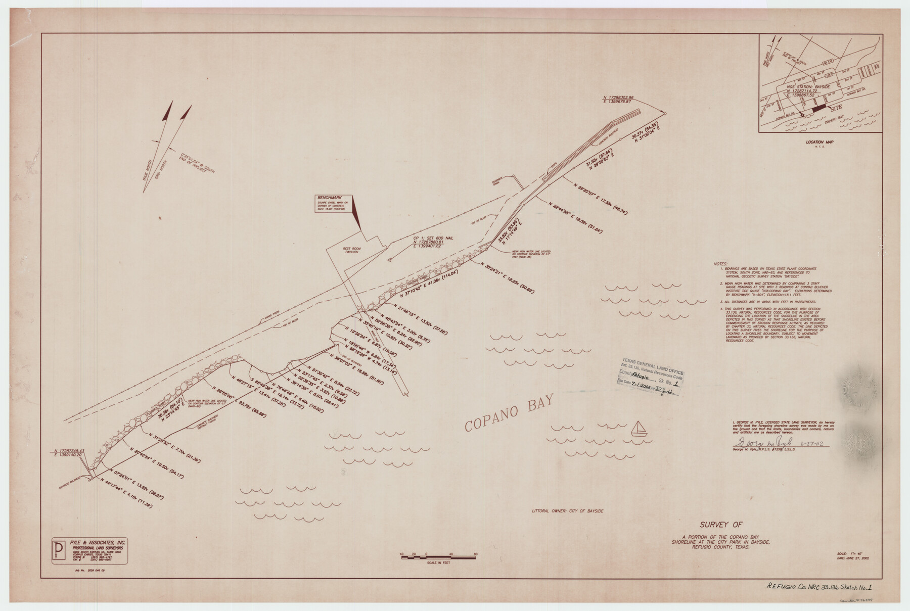
Refugio County NRC Article 33.136 Sketch 1
A Survey of a portion of the Copano Bay Shoreline at the City Park, Bayside
-
Map/Doc
76399
-
Collection
General Map Collection
-
Object Dates
6/27/2002 (Creation Date)
7/1/2002 (File Date)
-
People and Organizations
George M. Pyle (Surveyor/Engineer)
-
Counties
Refugio
-
Subjects
Surveying CBS
-
Height x Width
24.5 x 36.8 inches
62.2 x 93.5 cm
-
Medium
multi-page, multi-format
-
Comments
Survey located about 15 miles South 14 degrees East of Refugio, Texas.
Part of: General Map Collection
Childress County Sketch File 16

Print $8.00
- Digital $50.00
Childress County Sketch File 16
1888
Size 13.9 x 8.5 inches
Map/Doc 18282
Intracoastal Waterway - Laguna Madre - Chubby Island to Stover Point including the Arroyo Colorado, Texas

Print $20.00
- Digital $50.00
Intracoastal Waterway - Laguna Madre - Chubby Island to Stover Point including the Arroyo Colorado, Texas
1976
Size 16.0 x 43.9 inches
Map/Doc 75901
Newton County Working Sketch 6

Print $20.00
- Digital $50.00
Newton County Working Sketch 6
1930
Size 35.5 x 25.9 inches
Map/Doc 71252
Flight Mission No. CUG-1P, Frame 86, Kleberg County

Print $20.00
- Digital $50.00
Flight Mission No. CUG-1P, Frame 86, Kleberg County
1956
Size 18.5 x 22.2 inches
Map/Doc 86151
Williamson County Working Sketch 12

Print $20.00
- Digital $50.00
Williamson County Working Sketch 12
1977
Size 37.0 x 35.0 inches
Map/Doc 72572
Travis County Rolled Sketch 57

Print $20.00
- Digital $50.00
Travis County Rolled Sketch 57
1885
Size 16.5 x 23.3 inches
Map/Doc 8048
Flight Mission No. BRE-2P, Frame 12, Nueces County

Print $20.00
- Digital $50.00
Flight Mission No. BRE-2P, Frame 12, Nueces County
1956
Size 18.5 x 22.6 inches
Map/Doc 86721
Williamson County

Print $40.00
- Digital $50.00
Williamson County
1946
Size 37.3 x 54.8 inches
Map/Doc 77460
Edwards County Working Sketch 116

Print $20.00
- Digital $50.00
Edwards County Working Sketch 116
1973
Size 26.5 x 39.1 inches
Map/Doc 68992
Throckmorton County Sketch File 12

Print $20.00
- Digital $50.00
Throckmorton County Sketch File 12
Size 16.2 x 22.3 inches
Map/Doc 12435
Bosque County Sketch File 31

Print $6.00
- Digital $50.00
Bosque County Sketch File 31
1867
Size 8.5 x 10.5 inches
Map/Doc 14830
Map of Midland County

Print $20.00
- Digital $50.00
Map of Midland County
1901
Size 43.9 x 38.3 inches
Map/Doc 7825
You may also like
[Sketch for Mineral Application 24072, San Jacinto River]
![65590, [Sketch for Mineral Application 24072, San Jacinto River], General Map Collection](https://historictexasmaps.com/wmedia_w700/maps/65590.tif.jpg)
Print $20.00
- Digital $50.00
[Sketch for Mineral Application 24072, San Jacinto River]
1929
Size 40.8 x 14.7 inches
Map/Doc 65590
Brazoria County Sketch File 10a

Print $50.00
- Digital $50.00
Brazoria County Sketch File 10a
1912
Size 7.1 x 8.7 inches
Map/Doc 14940
Duval County Working Sketch 44

Print $20.00
- Digital $50.00
Duval County Working Sketch 44
1977
Size 27.5 x 40.7 inches
Map/Doc 68768
Galveston County Sketch File 50

Print $70.00
- Digital $50.00
Galveston County Sketch File 50
Size 14.2 x 8.7 inches
Map/Doc 23481
Travis County Rolled Sketch 29

Print $20.00
- Digital $50.00
Travis County Rolled Sketch 29
1946
Size 25.1 x 37.8 inches
Map/Doc 8031
Walker County

Print $20.00
- Digital $50.00
Walker County
1944
Size 44.8 x 38.5 inches
Map/Doc 63106
Starr County Sketch File 13

Print $20.00
- Digital $50.00
Starr County Sketch File 13
1886
Size 12.4 x 19.5 inches
Map/Doc 12329
Orange County Sketch File 31

Print $20.00
- Digital $50.00
Orange County Sketch File 31
1926
Size 17.9 x 20.0 inches
Map/Doc 12125
Capitol Lands survey by J. T. Munson

Print $20.00
- Digital $50.00
Capitol Lands survey by J. T. Munson
Size 25.6 x 21.0 inches
Map/Doc 90575
Fisher County

Print $40.00
- Digital $50.00
Fisher County
1944
Size 48.4 x 42.5 inches
Map/Doc 73147
![91955, [PSL Block B19], Twichell Survey Records](https://historictexasmaps.com/wmedia_w700/maps/91955-1.tif.jpg)
[H. & T. C. RR. Company, Block 47 and vicinity]
![91156, [H. & T. C. RR. Company, Block 47 and vicinity], Twichell Survey Records](https://historictexasmaps.com/wmedia_w700/maps/91156-1.tif.jpg)
Print $20.00
- Digital $50.00
[H. & T. C. RR. Company, Block 47 and vicinity]
Size 18.2 x 19.3 inches
Map/Doc 91156