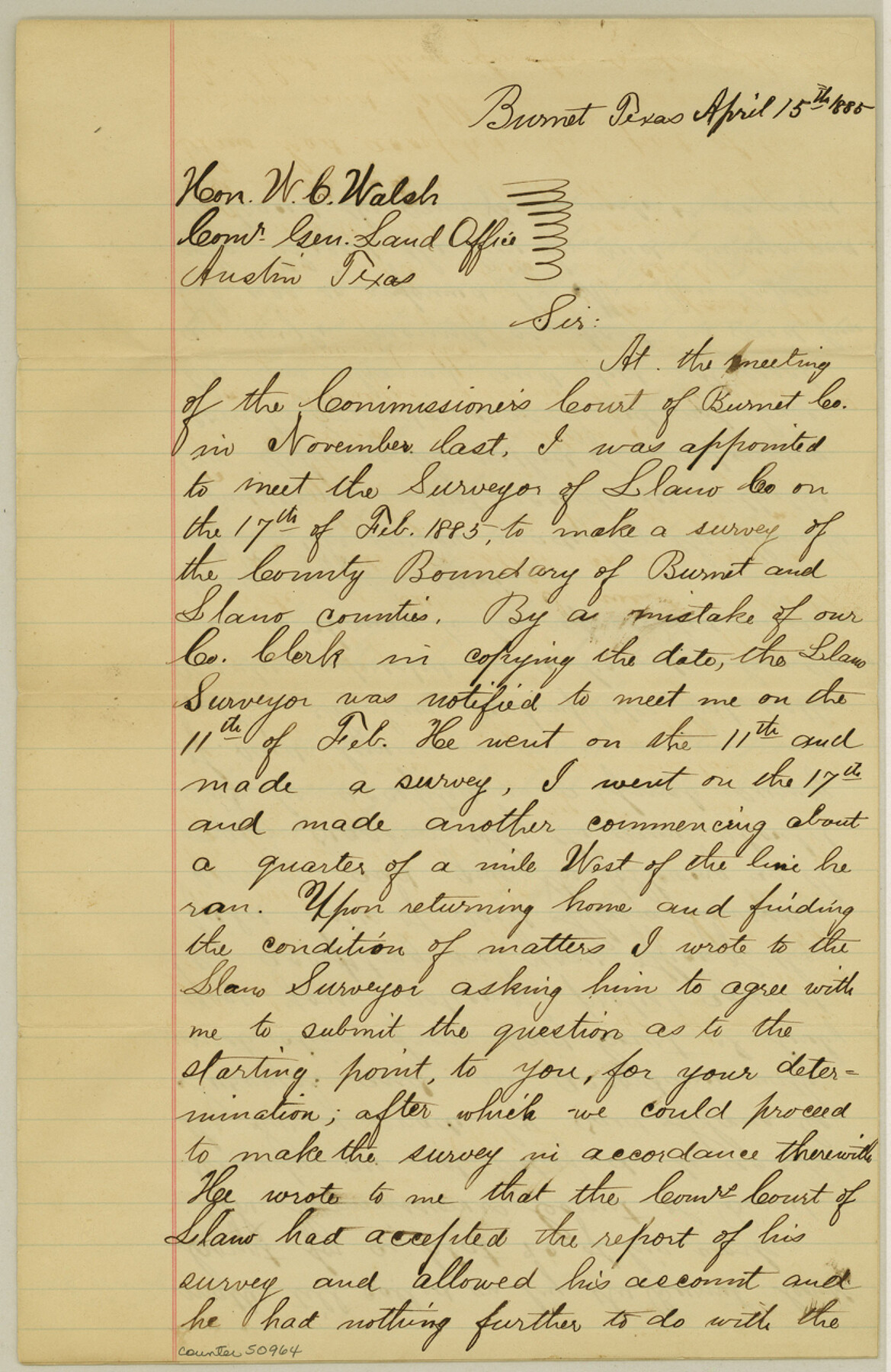
Burnet County Boundary File 12c
Letter regarding Burnet-Llano Boundary line
-
Map/Doc
50964
-
Collection
General Map Collection
-
Counties
Burnet
-
Subjects
County Boundaries
-
Height x Width
12.8 x 8.3 inches
32.5 x 21.1 cm
Part of: General Map Collection
Presidio County Sketch File 60a

Print $4.00
- Digital $50.00
Presidio County Sketch File 60a
1936
Size 8.7 x 15.5 inches
Map/Doc 34643
Flight Mission No. CGI-1N, Frame 144, Cameron County

Print $20.00
- Digital $50.00
Flight Mission No. CGI-1N, Frame 144, Cameron County
1955
Size 18.7 x 22.3 inches
Map/Doc 84500
Gillespie County Rolled Sketch O

Print $20.00
- Digital $50.00
Gillespie County Rolled Sketch O
1846
Size 42.6 x 20.0 inches
Map/Doc 6007
Railroad Track Map, H&TCRRCo., Falls County, Texas

Print $4.00
- Digital $50.00
Railroad Track Map, H&TCRRCo., Falls County, Texas
1918
Size 11.8 x 18.5 inches
Map/Doc 62837
Terry County Sketch File 2

Print $8.00
- Digital $50.00
Terry County Sketch File 2
Size 8.9 x 11.4 inches
Map/Doc 38012
Right of Way & Track Map San Antonio & Aransas Pass Railway Co.

Print $40.00
- Digital $50.00
Right of Way & Track Map San Antonio & Aransas Pass Railway Co.
1919
Size 25.1 x 56.7 inches
Map/Doc 64026
Denton County Sketch File 29 1/2

Print $4.00
- Digital $50.00
Denton County Sketch File 29 1/2
Size 14.8 x 9.1 inches
Map/Doc 20758
Flight Mission No. DQO-8K, Frame 75, Galveston County

Print $20.00
- Digital $50.00
Flight Mission No. DQO-8K, Frame 75, Galveston County
1952
Size 18.7 x 22.5 inches
Map/Doc 85179
Baylor County Sketch File 32

Print $10.00
- Digital $50.00
Baylor County Sketch File 32
Size 10.2 x 8.2 inches
Map/Doc 14238
Brewster County Working Sketch 10

Print $20.00
- Digital $50.00
Brewster County Working Sketch 10
1910
Size 17.8 x 16.8 inches
Map/Doc 67543
Hemphill County Rolled Sketch 6

Print $20.00
- Digital $50.00
Hemphill County Rolled Sketch 6
Size 22.2 x 24.7 inches
Map/Doc 6188
Real County Rolled Sketch 20

Print $20.00
- Digital $50.00
Real County Rolled Sketch 20
2004
Size 24.6 x 35.8 inches
Map/Doc 82573
You may also like
Kent County Working Sketch 18

Print $20.00
- Digital $50.00
Kent County Working Sketch 18
1974
Size 33.5 x 31.5 inches
Map/Doc 70025
Republic of Texas and boundaries as claimed by Texas from Decr. 19th, 1836 to Novr. 26th, 1850

Print $20.00
- Digital $50.00
Republic of Texas and boundaries as claimed by Texas from Decr. 19th, 1836 to Novr. 26th, 1850
1897
Size 20.7 x 19.3 inches
Map/Doc 93411
Map of the River Sabine from its mouth on the Gulf of Mexico in the Sea to Logan's Ferry in Latitude 31°58'24" North

Print $40.00
- Digital $50.00
Map of the River Sabine from its mouth on the Gulf of Mexico in the Sea to Logan's Ferry in Latitude 31°58'24" North
1842
Size 60.5 x 30.6 inches
Map/Doc 87151
Terrell County Sketch File 31

Print $20.00
- Digital $50.00
Terrell County Sketch File 31
1940
Size 27.0 x 25.1 inches
Map/Doc 12426
Texas-Oklahoma Clara Quadrangle

Print $20.00
- Digital $50.00
Texas-Oklahoma Clara Quadrangle
1937
Size 20.3 x 16.9 inches
Map/Doc 75105
South Part Pecos County

Print $20.00
- Digital $50.00
South Part Pecos County
1976
Size 37.9 x 45.3 inches
Map/Doc 95613
Wharton County Working Sketch 18

Print $20.00
- Digital $50.00
Wharton County Working Sketch 18
1948
Size 19.3 x 17.0 inches
Map/Doc 72482

Flight Mission No. DCL-5C, Frame 51, Kenedy County

Print $20.00
- Digital $50.00
Flight Mission No. DCL-5C, Frame 51, Kenedy County
1943
Size 18.5 x 22.2 inches
Map/Doc 85847
Harris County Boundary File 39 (1)

Print $45.00
- Digital $50.00
Harris County Boundary File 39 (1)
Size 4.5 x 16.3 inches
Map/Doc 54326
Flight Mission No. DAG-17K, Frame 75, Matagorda County

Print $20.00
- Digital $50.00
Flight Mission No. DAG-17K, Frame 75, Matagorda County
1952
Size 16.5 x 16.5 inches
Map/Doc 86334
Ward County Rolled Sketch 21

Print $20.00
- Digital $50.00
Ward County Rolled Sketch 21
1951
Size 21.1 x 43.3 inches
Map/Doc 8163