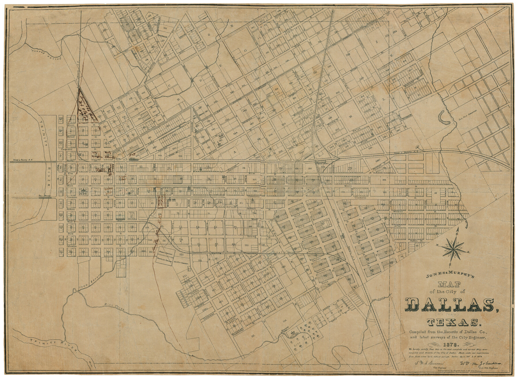
Jones & Murphy's Map of the City of Dallas, Texas compiled from the records of Dallas Co., and latest surveys of the City Engineer
-
Map/Doc
97262
-
Collection
General Map Collection
-
Object Dates
4/22/1878 (Creation Date)
-
People and Organizations
August Gast & Co. (Lithographer)
S.W.S. Duncan (Surveyor/Engineer)
Wm. M. Johnson (Surveyor/Engineer)
-
Counties
Dallas
-
Subjects
City
-
Height x Width
22.0 x 29.9 inches
55.9 x 76.0 cm
Part of: General Map Collection
Coast Chart No. 210 - Aransas Pass and Corpus Christi Bay with the coast to latitude 27° 12', Texas

Print $20.00
- Digital $50.00
Coast Chart No. 210 - Aransas Pass and Corpus Christi Bay with the coast to latitude 27° 12', Texas
1887
Size 30.4 x 24.0 inches
Map/Doc 73444
Winkler County Working Sketch Graphic Index

Print $20.00
- Digital $50.00
Winkler County Working Sketch Graphic Index
1932
Size 36.4 x 36.4 inches
Map/Doc 76744
Red River County Working Sketch 19

Print $40.00
- Digital $50.00
Red River County Working Sketch 19
1955
Size 55.0 x 38.6 inches
Map/Doc 72002
Galveston County NRC Article 33.136 Sketch 31

Print $22.00
- Digital $50.00
Galveston County NRC Article 33.136 Sketch 31
2005
Size 22.2 x 33.7 inches
Map/Doc 83280
Milam County Boundary File 6b

Print $40.00
- Digital $50.00
Milam County Boundary File 6b
Size 31.1 x 48.8 inches
Map/Doc 57249
Bee County Sketch File 23

Print $8.00
- Digital $50.00
Bee County Sketch File 23
1878
Size 10.0 x 8.1 inches
Map/Doc 14318
Chambers County Working Sketch 2

Print $20.00
- Digital $50.00
Chambers County Working Sketch 2
1904
Size 34.6 x 25.3 inches
Map/Doc 67985
Rio Grande from San Juan River to the Gulf of Mexico showing Boundary between the United States and Mexico

Print $20.00
- Digital $50.00
Rio Grande from San Juan River to the Gulf of Mexico showing Boundary between the United States and Mexico
1903
Size 25.6 x 15.8 inches
Map/Doc 2065
Flight Mission No. DIX-5P, Frame 144, Aransas County

Print $20.00
- Digital $50.00
Flight Mission No. DIX-5P, Frame 144, Aransas County
1956
Size 17.2 x 17.6 inches
Map/Doc 83805
Haskell County Working Sketch 3

Print $20.00
- Digital $50.00
Haskell County Working Sketch 3
1920
Size 41.4 x 21.9 inches
Map/Doc 66061
Flight Mission No. CGI-3N, Frame 76, Cameron County

Print $20.00
- Digital $50.00
Flight Mission No. CGI-3N, Frame 76, Cameron County
1954
Size 18.5 x 22.1 inches
Map/Doc 84570
Jeff Davis County Rolled Sketch 11

Print $20.00
- Digital $50.00
Jeff Davis County Rolled Sketch 11
1914
Size 17.9 x 14.4 inches
Map/Doc 6364
You may also like
Stephens County Boundary File 4

Print $6.00
- Digital $50.00
Stephens County Boundary File 4
Size 14.3 x 8.8 inches
Map/Doc 58894
Flight Mission No. BRA-8M, Frame 113, Jefferson County

Print $20.00
- Digital $50.00
Flight Mission No. BRA-8M, Frame 113, Jefferson County
1953
Size 18.6 x 22.3 inches
Map/Doc 85609
Flight Mission No. BRE-2P, Frame 19, Nueces County

Print $20.00
- Digital $50.00
Flight Mission No. BRE-2P, Frame 19, Nueces County
1956
Size 18.4 x 22.2 inches
Map/Doc 86728
Flight Mission No. DIX-8P, Frame 85, Aransas County

Print $20.00
- Digital $50.00
Flight Mission No. DIX-8P, Frame 85, Aransas County
1956
Size 18.4 x 19.0 inches
Map/Doc 83910
[Surveys along Cow and Deer Creeks]
![306, [Surveys along Cow and Deer Creeks], General Map Collection](https://historictexasmaps.com/wmedia_w700/maps/306.tif.jpg)
Print $2.00
- Digital $50.00
[Surveys along Cow and Deer Creeks]
1845
Size 15.8 x 8.6 inches
Map/Doc 306
Harris County Historic Topographic 14

Print $20.00
- Digital $50.00
Harris County Historic Topographic 14
1916
Size 29.1 x 22.6 inches
Map/Doc 65824
Crosby County Working Sketch 5

Print $20.00
- Digital $50.00
Crosby County Working Sketch 5
1911
Size 23.3 x 16.7 inches
Map/Doc 68439
Upton County Boundary File 1

Print $5.00
- Digital $50.00
Upton County Boundary File 1
Size 13.4 x 9.0 inches
Map/Doc 59506
Jack County Sketch File 18b

Print $4.00
- Digital $50.00
Jack County Sketch File 18b
Size 8.0 x 12.9 inches
Map/Doc 27557
Haskell County Boundary File 2

Print $2.00
- Digital $50.00
Haskell County Boundary File 2
Size 10.7 x 8.3 inches
Map/Doc 54538
[Sketch for Mineral Application 16777]
![65654, [Sketch for Mineral Application 16777], General Map Collection](https://historictexasmaps.com/wmedia_w700/maps/65654-1.tif.jpg)
Print $40.00
- Digital $50.00
[Sketch for Mineral Application 16777]
Size 80.1 x 19.7 inches
Map/Doc 65654
Liberty County Rolled Sketch OB

Print $40.00
- Digital $50.00
Liberty County Rolled Sketch OB
1934
Size 71.0 x 24.8 inches
Map/Doc 9563