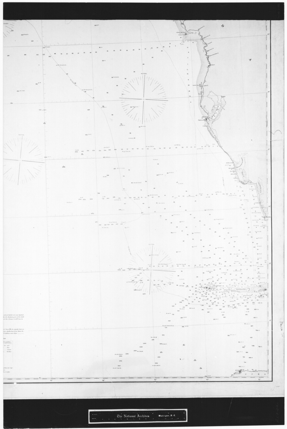
Gulf Coast of the United States, Key West to Rio Grande
RL-1-4a
-
Map/Doc
72666
-
Collection
General Map Collection
-
Object Dates
1863 (Creation Date)
-
People and Organizations
U. S. Coast Survey Office (Author)
-
Subjects
Nautical Charts
-
Height x Width
27.4 x 18.3 inches
69.6 x 46.5 cm
-
Comments
B/W photostat copy from National Archives in multiple pieces. Chart No. 5, Edition 2, Plate No. 1451, 1878
Part of: General Map Collection
Runnels County Rolled Sketch 1

Print $20.00
- Digital $50.00
Runnels County Rolled Sketch 1
1854
Size 28.0 x 18.4 inches
Map/Doc 75941
Live Oak County Working Sketch 22

Print $40.00
- Digital $50.00
Live Oak County Working Sketch 22
1976
Size 63.1 x 31.9 inches
Map/Doc 70607
Map of The Surveyed Part of Peters Colony Texas

Print $40.00
- Digital $50.00
Map of The Surveyed Part of Peters Colony Texas
1854
Size 53.5 x 65.9 inches
Map/Doc 1967
[Surveys in Austin's Colony along the Navidad River, Caney Fork, and upper Rocky Creek]
![201, [Surveys in Austin's Colony along the Navidad River, Caney Fork, and upper Rocky Creek], General Map Collection](https://historictexasmaps.com/wmedia_w700/maps/201-1.tif.jpg)
Print $20.00
- Digital $50.00
[Surveys in Austin's Colony along the Navidad River, Caney Fork, and upper Rocky Creek]
1831
Size 20.5 x 26.7 inches
Map/Doc 201
Map of a part of Fisher and Miller's Colony - Harvey's District

Print $20.00
- Digital $50.00
Map of a part of Fisher and Miller's Colony - Harvey's District
1856
Size 19.0 x 24.7 inches
Map/Doc 4657
Lipscomb County Boundary File 7

Print $4.00
- Digital $50.00
Lipscomb County Boundary File 7
Size 6.6 x 8.1 inches
Map/Doc 56331
Coke County Rolled Sketch 13

Print $40.00
- Digital $50.00
Coke County Rolled Sketch 13
Size 44.5 x 69.9 inches
Map/Doc 8627
Flight Mission No. CRK-7P, Frame 82, Refugio County

Print $20.00
- Digital $50.00
Flight Mission No. CRK-7P, Frame 82, Refugio County
1956
Size 18.3 x 22.1 inches
Map/Doc 86953
Knox County Sketch File 25

Print $10.00
- Digital $50.00
Knox County Sketch File 25
1872
Size 12.8 x 8.2 inches
Map/Doc 29257
Flight Mission No. DIX-3P, Frame 138, Aransas County

Print $20.00
- Digital $50.00
Flight Mission No. DIX-3P, Frame 138, Aransas County
1956
Size 17.7 x 18.6 inches
Map/Doc 83768
Leon County Sketch File 11a

Print $4.00
- Digital $50.00
Leon County Sketch File 11a
Size 9.7 x 8.7 inches
Map/Doc 29763
Terry County Boundary File 3

Print $78.00
- Digital $50.00
Terry County Boundary File 3
Size 7.4 x 8.8 inches
Map/Doc 59216
You may also like
Knox County Rolled Sketch 23

Print $20.00
- Digital $50.00
Knox County Rolled Sketch 23
1989
Size 34.4 x 29.0 inches
Map/Doc 76408
Flight Mission No. DCL-7C, Frame 144, Kenedy County

Print $20.00
- Digital $50.00
Flight Mission No. DCL-7C, Frame 144, Kenedy County
1943
Size 18.6 x 22.5 inches
Map/Doc 86101
Hill County Sketch File 1

Print $4.00
- Digital $50.00
Hill County Sketch File 1
1857
Size 9.0 x 7.9 inches
Map/Doc 26459
Milam County Rolled Sketch 3A

Print $40.00
- Digital $50.00
Milam County Rolled Sketch 3A
1967
Size 49.5 x 43.3 inches
Map/Doc 9522
Detail Sketch of A.B. Robertson's Ranch and J.W. James' Ranch situated in Garza and Crosby Counties, Texas

Print $40.00
- Digital $50.00
Detail Sketch of A.B. Robertson's Ranch and J.W. James' Ranch situated in Garza and Crosby Counties, Texas
Size 50.9 x 32.4 inches
Map/Doc 89945
Map of Stephens County

Print $20.00
- Digital $50.00
Map of Stephens County
1897
Size 42.8 x 37.5 inches
Map/Doc 78394
Sterling County Rolled Sketch X

Print $117.00
- Digital $50.00
Sterling County Rolled Sketch X
Size 15.3 x 9.6 inches
Map/Doc 49097
Goliad Station Map, Galveston, Harrisburg & San Antonio Ry. operated by the T. & N. O. R.R. Co.

Print $40.00
- Digital $50.00
Goliad Station Map, Galveston, Harrisburg & San Antonio Ry. operated by the T. & N. O. R.R. Co.
1918
Size 24.7 x 55.8 inches
Map/Doc 76161
Orange County Working Sketch 43

Print $20.00
- Digital $50.00
Orange County Working Sketch 43
1980
Size 18.3 x 18.4 inches
Map/Doc 71375
Live Oak County

Print $40.00
- Digital $50.00
Live Oak County
1899
Size 51.5 x 38.4 inches
Map/Doc 5018
Northern Part of Laguna Madre

Print $20.00
- Digital $50.00
Northern Part of Laguna Madre
1935
Size 44.4 x 35.1 inches
Map/Doc 73522
Map of Harrison County

Print $20.00
- Digital $50.00
Map of Harrison County
1840
Size 44.6 x 34.5 inches
Map/Doc 1515