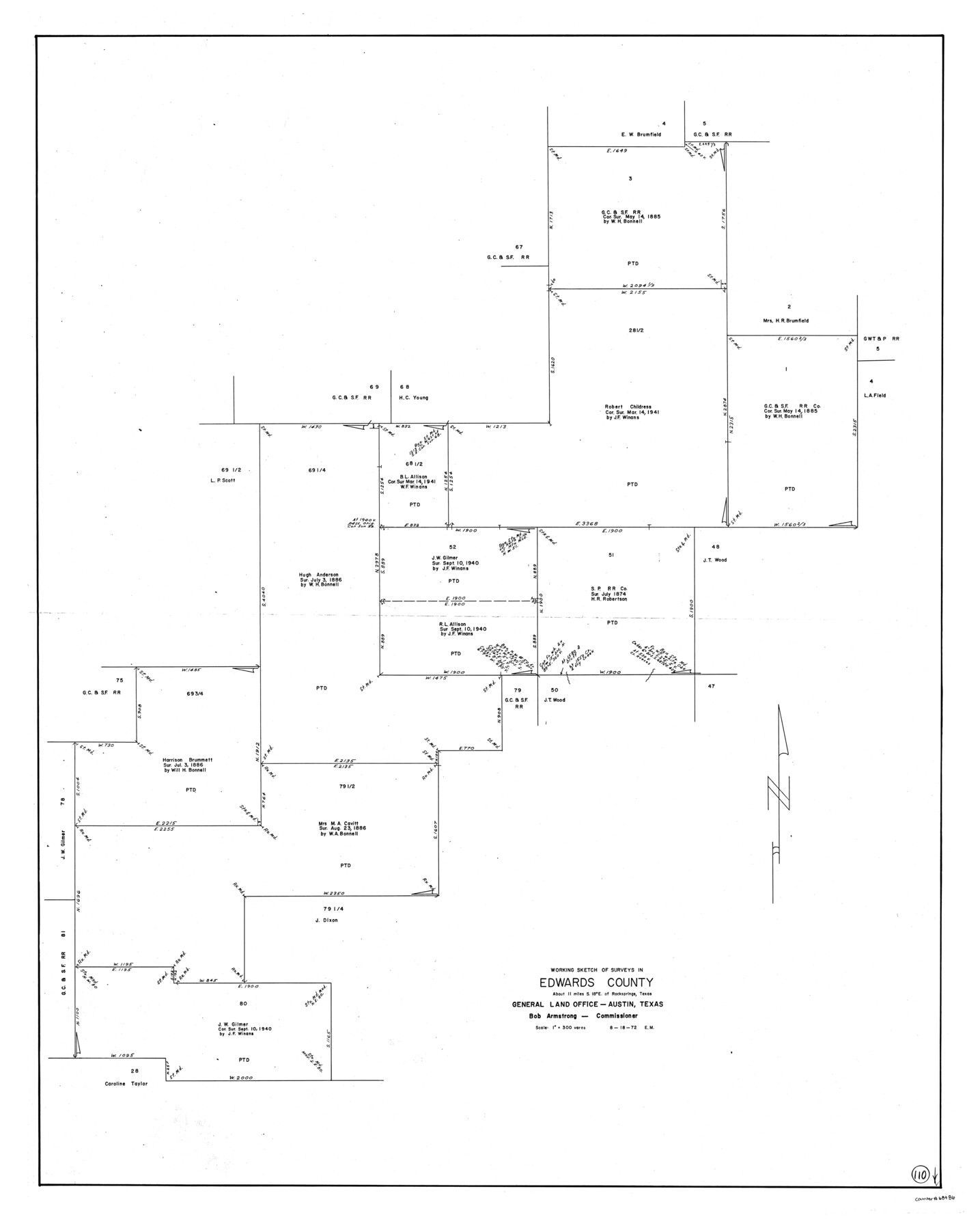
Edwards County Working Sketch 110
-
Map/Doc
68986
-
Collection
General Map Collection
-
Counties
Edwards
-
Subjects
Cadastral Surveying Working Sketch
-
Height x Width
49.7 x 39.6 inches
126.2 x 100.6 cm
Part of: General Map Collection
Texas & Pacific Ry Reserve west of the Pecos River
![3047, Texas & Pacific Ry Reserve west of the Pecos River, General Map Collection](https://historictexasmaps.com/wmedia_w700/maps/3047-GC.tif.jpg)
Print $40.00
- Digital $50.00
Texas & Pacific Ry Reserve west of the Pecos River
1880
Size 43.9 x 90.6 inches
Map/Doc 3047
[Sketch for Mineral Application 24072, San Jacinto River]
![65588, [Sketch for Mineral Application 24072, San Jacinto River], General Map Collection](https://historictexasmaps.com/wmedia_w700/maps/65588.tif.jpg)
Print $20.00
- Digital $50.00
[Sketch for Mineral Application 24072, San Jacinto River]
1929
Size 19.6 x 13.7 inches
Map/Doc 65588
Hardeman County Aerial Photograph Index Sheet 1
![83697, Hardeman County Aerial Photograph Index Sheet 1, General Map Collection](https://historictexasmaps.com/wmedia_w700/pdf_converted_jpg/qi_pdf_thumbnail_30918.jpg)
Print $20.00
- Digital $50.00
Hardeman County Aerial Photograph Index Sheet 1
1950
Size 19.8 x 17.0 inches
Map/Doc 83697
[Map of Block 97, Borden and Scurry Co (Exhibit A); Map of Southeastern part of Young Territory; Map of part of of Borden, Fisher, Kent, Mitchell, Scurry and Garza Cos. Showing the north boundary line of the T&P 80 mile reservation]
![65692, [Map of Block 97, Borden and Scurry Co (Exhibit A); Map of Southeastern part of Young Territory; Map of part of of Borden, Fisher, Kent, Mitchell, Scurry and Garza Cos. Showing the north boundary line of the T&P 80 mile reservation], General Map Collection](https://historictexasmaps.com/wmedia_w700/maps/65692.tif.jpg)
Print $20.00
- Digital $50.00
[Map of Block 97, Borden and Scurry Co (Exhibit A); Map of Southeastern part of Young Territory; Map of part of of Borden, Fisher, Kent, Mitchell, Scurry and Garza Cos. Showing the north boundary line of the T&P 80 mile reservation]
1873
Size 33.4 x 29.6 inches
Map/Doc 65692
Map of Jefferson County
![3725, Map of Jefferson County, General Map Collection](https://historictexasmaps.com/wmedia_w700/maps/3725.tif.jpg)
Print $20.00
- Digital $50.00
Map of Jefferson County
1840
Size 32.7 x 23.4 inches
Map/Doc 3725
Haskell County Boundary File 4
![54542, Haskell County Boundary File 4, General Map Collection](https://historictexasmaps.com/wmedia_w700/pdf_converted_jpg/qi_pdf_thumbnail_16195.jpg)
Print $6.00
- Digital $50.00
Haskell County Boundary File 4
Size 11.2 x 8.9 inches
Map/Doc 54542
Current Miscellaneous File 3
![73706, Current Miscellaneous File 3, General Map Collection](https://historictexasmaps.com/wmedia_w700/pdf_converted_jpg/qi_pdf_thumbnail_27650.jpg)
Print $34.00
- Digital $50.00
Current Miscellaneous File 3
1947
Size 9.0 x 6.2 inches
Map/Doc 73706
Galveston County NRC Article 33.136 Sketch 48
![88611, Galveston County NRC Article 33.136 Sketch 48, General Map Collection](https://historictexasmaps.com/wmedia_w700/pdf_converted_jpg/qi_pdf_thumbnail_34357.jpg)
Print $22.00
- Digital $50.00
Galveston County NRC Article 33.136 Sketch 48
2006
Size 24.4 x 36.7 inches
Map/Doc 88611
Crockett County Working Sketch 87
![68420, Crockett County Working Sketch 87, General Map Collection](https://historictexasmaps.com/wmedia_w700/maps/68420.tif.jpg)
Print $20.00
- Digital $50.00
Crockett County Working Sketch 87
Size 35.5 x 43.8 inches
Map/Doc 68420
Travis County Working Sketch 9
![69393, Travis County Working Sketch 9, General Map Collection](https://historictexasmaps.com/wmedia_w700/maps/69393.tif.jpg)
Print $20.00
- Digital $50.00
Travis County Working Sketch 9
Size 21.9 x 28.9 inches
Map/Doc 69393
Navigation Maps of Gulf Intracoastal Waterway, Port Arthur to Brownsville, Texas
![65440, Navigation Maps of Gulf Intracoastal Waterway, Port Arthur to Brownsville, Texas, General Map Collection](https://historictexasmaps.com/wmedia_w700/maps/65440.tif.jpg)
Print $4.00
- Digital $50.00
Navigation Maps of Gulf Intracoastal Waterway, Port Arthur to Brownsville, Texas
1951
Size 16.6 x 21.5 inches
Map/Doc 65440
You may also like
Jefferson County NRC Article 33.136 Sketch 7
![94711, Jefferson County NRC Article 33.136 Sketch 7, General Map Collection](https://historictexasmaps.com/wmedia_w700/pdf_converted_jpg/qi_pdf_thumbnail_39189.jpg)
Print $24.00
- Digital $50.00
Jefferson County NRC Article 33.136 Sketch 7
2009
Size 30.8 x 43.0 inches
Map/Doc 94711
Gray County Sketch File 5
![24418, Gray County Sketch File 5, General Map Collection](https://historictexasmaps.com/wmedia_w700/pdf_converted_jpg/qi_pdf_thumbnail_11448.jpg)
Print $16.00
- Digital $50.00
Gray County Sketch File 5
1882
Size 12.8 x 8.3 inches
Map/Doc 24418
Parker County Sketch File 40
![33585, Parker County Sketch File 40, General Map Collection](https://historictexasmaps.com/wmedia_w700/pdf_converted_jpg/qi_pdf_thumbnail_13531.jpg)
Print $4.00
- Digital $50.00
Parker County Sketch File 40
Size 8.1 x 12.7 inches
Map/Doc 33585
Hall County Working Sketch Graphic Index
![76563, Hall County Working Sketch Graphic Index, General Map Collection](https://historictexasmaps.com/wmedia_w700/maps/76563.tif.jpg)
Print $20.00
- Digital $50.00
Hall County Working Sketch Graphic Index
1972
Size 41.7 x 33.7 inches
Map/Doc 76563
General Highway Map, Coleman County, Texas
![79051, General Highway Map, Coleman County, Texas, Texas State Library and Archives](https://historictexasmaps.com/wmedia_w700/maps/79051.tif.jpg)
Print $20.00
General Highway Map, Coleman County, Texas
1940
Size 18.4 x 25.2 inches
Map/Doc 79051
Hood County Sketch File 9
![26586, Hood County Sketch File 9, General Map Collection](https://historictexasmaps.com/wmedia_w700/pdf_converted_jpg/qi_pdf_thumbnail_11930.jpg)
Print $26.00
- Digital $50.00
Hood County Sketch File 9
1859
Size 9.6 x 4.5 inches
Map/Doc 26586
Cochran County Rolled Sketch 4
![5501, Cochran County Rolled Sketch 4, General Map Collection](https://historictexasmaps.com/wmedia_w700/maps/5501.tif.jpg)
Print $20.00
- Digital $50.00
Cochran County Rolled Sketch 4
1945
Size 16.8 x 23.7 inches
Map/Doc 5501
Rusk County Rolled Sketch 7
![9876, Rusk County Rolled Sketch 7, General Map Collection](https://historictexasmaps.com/wmedia_w700/maps/9876.tif.jpg)
Print $20.00
- Digital $50.00
Rusk County Rolled Sketch 7
Size 43.0 x 37.3 inches
Map/Doc 9876
Midland County Working Sketch 24
![71005, Midland County Working Sketch 24, General Map Collection](https://historictexasmaps.com/wmedia_w700/maps/71005.tif.jpg)
Print $40.00
- Digital $50.00
Midland County Working Sketch 24
Size 42.9 x 80.9 inches
Map/Doc 71005
Brown County Sketch File 11
![16597, Brown County Sketch File 11, General Map Collection](https://historictexasmaps.com/wmedia_w700/pdf_converted_jpg/qi_pdf_thumbnail_9705.jpg)
Print $4.00
- Digital $50.00
Brown County Sketch File 11
1859
Size 7.7 x 9.9 inches
Map/Doc 16597
Harris County NRC Article 33.136 Sketch 1
![61595, Harris County NRC Article 33.136 Sketch 1, General Map Collection](https://historictexasmaps.com/wmedia_w700/pdf_converted_jpg/qi_pdf_thumbnail_17176.jpg)
Print $26.00
- Digital $50.00
Harris County NRC Article 33.136 Sketch 1
2000
Size 24.3 x 36.3 inches
Map/Doc 61595
Louisiana and Texas Intracoastal Waterway
![83347, Louisiana and Texas Intracoastal Waterway, General Map Collection](https://historictexasmaps.com/wmedia_w700/maps/83347.tif.jpg)
Print $20.00
- Digital $50.00
Louisiana and Texas Intracoastal Waterway
Size 13.9 x 19.0 inches
Map/Doc 83347