Hale County Sketch File 5-5a
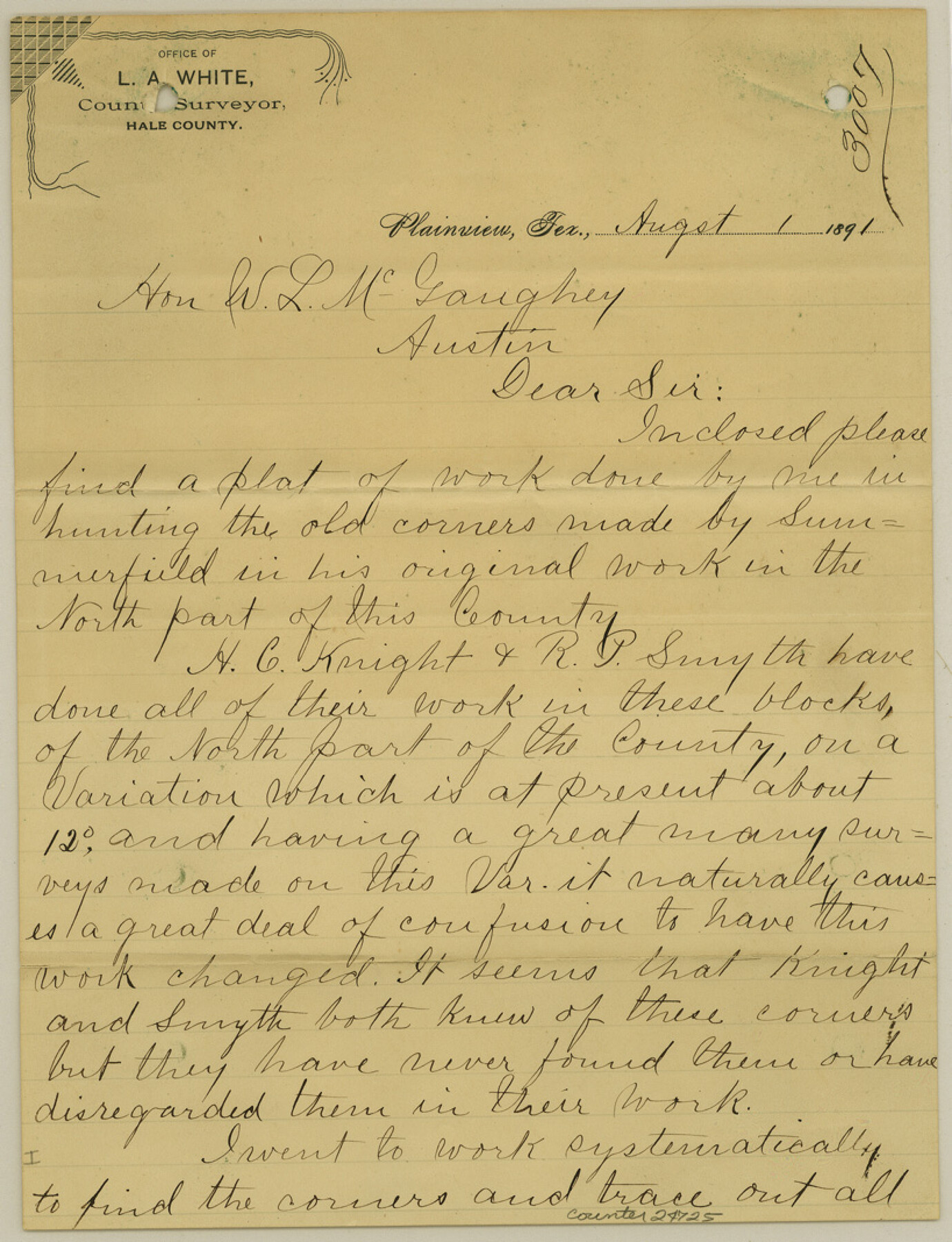
[Field notes and report of Block lines for Blocks JK, O6 and S4]
-
Map/Doc
10467
-
Collection
General Map Collection
-
Object Dates
1891/4/9 (Creation Date)
1891/8/5 (File Date)
1891/8/1 (Creation Date)
1891 (Survey Date)
-
People and Organizations
L.A. White (Surveyor/Engineer)
Jonathan Summerfield (Surveyor/Engineer)
H.C. Knight (Surveyor/Engineer)
R.P. Smyth (Surveyor/Engineer)
A.L. King (Chainman)
W.J. Adz (Chainman)
-
Counties
Hale
-
Subjects
Surveying Sketch File
-
Height x Width
17.7 x 38.3 inches
45.0 x 97.3 cm
-
Medium
multi-page, multi-format
-
Features
White River Draw
Brazos River
Part of: General Map Collection
Val Verde County Working Sketch 66

Print $20.00
- Digital $50.00
Val Verde County Working Sketch 66
1964
Size 42.1 x 46.9 inches
Map/Doc 72201
Bandera County Sketch File 30

Print $40.00
- Digital $50.00
Bandera County Sketch File 30
Size 16.8 x 13.4 inches
Map/Doc 14021
Medina County Rolled Sketch 17

Print $20.00
- Digital $50.00
Medina County Rolled Sketch 17
1979
Size 32.3 x 18.9 inches
Map/Doc 6750
Map of Runnels County

Print $20.00
- Digital $50.00
Map of Runnels County
1867
Size 27.3 x 19.3 inches
Map/Doc 4003
Brewster County Working Sketch 95

Print $40.00
- Digital $50.00
Brewster County Working Sketch 95
1975
Size 55.5 x 38.6 inches
Map/Doc 67695

Castro County Sketch File 6

Print $20.00
- Digital $50.00
Castro County Sketch File 6
Size 20.8 x 15.6 inches
Map/Doc 11059
Madison County Working Sketch 6

Print $2.00
- Digital $50.00
Madison County Working Sketch 6
1982
Size 10.5 x 7.7 inches
Map/Doc 70768

Flight Mission No. BRA-16M, Frame 175, Jefferson County

Print $20.00
- Digital $50.00
Flight Mission No. BRA-16M, Frame 175, Jefferson County
1953
Size 18.6 x 22.4 inches
Map/Doc 85773
Corrected Map of T&P Ry. surveys in counties Pecos-Presidio-El Paso

Print $20.00
- Digital $50.00
Corrected Map of T&P Ry. surveys in counties Pecos-Presidio-El Paso
1884
Size 27.9 x 39.0 inches
Map/Doc 2301
Erath County Working Sketch 50b

Print $20.00
- Digital $50.00
Erath County Working Sketch 50b
Size 43.4 x 25.8 inches
Map/Doc 69132
You may also like
Burnet County Sketch File 15

Print $4.00
- Digital $50.00
Burnet County Sketch File 15
Size 8.3 x 10.3 inches
Map/Doc 16702
Dallam County

Print $20.00
- Digital $50.00
Dallam County
1901
Size 43.8 x 29.3 inches
Map/Doc 93458
Jeff Davis County Working Sketch 8

Print $20.00
- Digital $50.00
Jeff Davis County Working Sketch 8
1940
Size 45.4 x 42.9 inches
Map/Doc 66503

[Surveys in Austin's Colony along New Year's Creek]
![204, [Surveys in Austin's Colony along New Year's Creek], General Map Collection](https://historictexasmaps.com/wmedia_w700/maps/204.tif.jpg)
Print $20.00
- Digital $50.00
[Surveys in Austin's Colony along New Year's Creek]
1828
Size 12.9 x 15.5 inches
Map/Doc 204
Rusk County Sketch File 17a

Print $4.00
Rusk County Sketch File 17a
Size 8.4 x 7.8 inches
Map/Doc 35522
Flight Mission No. CUG-1P, Frame 53, Kleberg County

Print $20.00
- Digital $50.00
Flight Mission No. CUG-1P, Frame 53, Kleberg County
1956
Size 18.6 x 22.4 inches
Map/Doc 86131
Plat of 83.94 acre vacant tract of land showing connections to adjoining surveys

Print $20.00
- Digital $50.00
Plat of 83.94 acre vacant tract of land showing connections to adjoining surveys
1918
Size 17.7 x 21.1 inches
Map/Doc 90823
Laguna Madre, T-9210

Print $20.00
- Digital $50.00
Laguna Madre, T-9210
Size 34.6 x 31.9 inches
Map/Doc 73601
Lubbock County Sketch File 3

Print $4.00
- Digital $50.00
Lubbock County Sketch File 3
1901
Size 13.0 x 8.2 inches
Map/Doc 30420
Baylor County Sketch File Z2

Print $40.00
- Digital $50.00
Baylor County Sketch File Z2
Size 28.5 x 31.3 inches
Map/Doc 10913
Nacogdoches County Sketch File 9

Print $20.00
- Digital $50.00
Nacogdoches County Sketch File 9
Size 8.3 x 26.9 inches
Map/Doc 32252