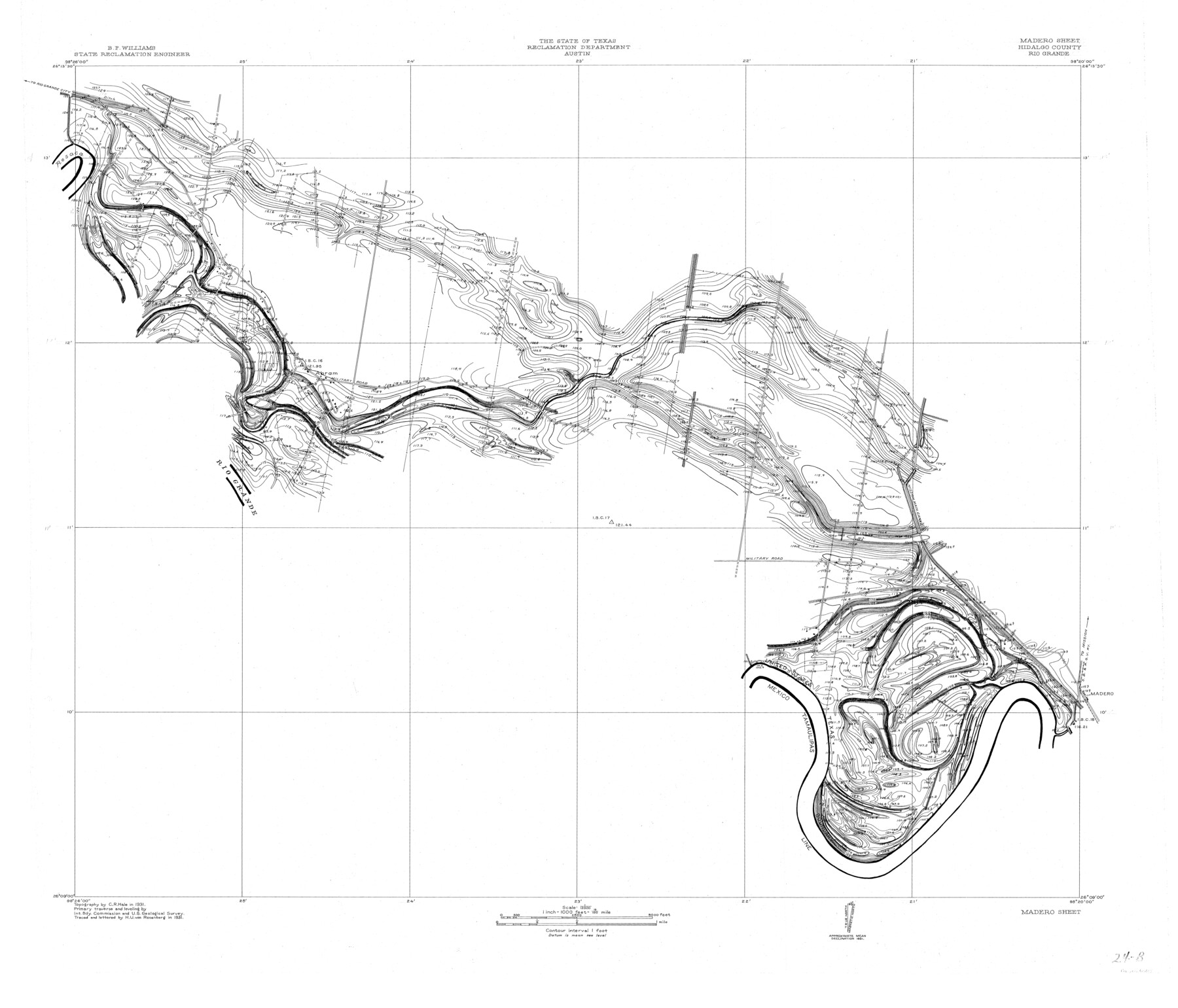
Rio Grande, Madero Sheet
-
Map/Doc
65124
-
Collection
General Map Collection
-
Object Dates
1931 (Creation Date)
-
People and Organizations
Texas State Reclamation Department (Publisher)
H.U. von Rosenberg (Draftsman)
H.U. von Rosenberg (Compiler)
C.R. Hale (Surveyor/Engineer)
-
Counties
Hidalgo
-
Subjects
River Surveys Topographic
-
Height x Width
33.0 x 38.5 inches
83.8 x 97.8 cm
Part of: General Map Collection
Texas Coordinate File 6

Print $40.00
- Digital $50.00
Texas Coordinate File 6
1946
Size 23.7 x 49.0 inches
Map/Doc 75314
Flight Mission No. DQO-8K, Frame 134, Galveston County

Print $20.00
- Digital $50.00
Flight Mission No. DQO-8K, Frame 134, Galveston County
1952
Size 18.7 x 22.3 inches
Map/Doc 85199
La Salle County Working Sketch 56

Print $20.00
- Digital $50.00
La Salle County Working Sketch 56
2012
Size 25.5 x 23.0 inches
Map/Doc 93277
Concho County Working Sketch 20

Print $20.00
- Digital $50.00
Concho County Working Sketch 20
1957
Size 40.0 x 38.1 inches
Map/Doc 68202

Travis County Working Sketch 56

Print $20.00
- Digital $50.00
Travis County Working Sketch 56
1989
Size 19.7 x 20.4 inches
Map/Doc 69440
Aransas County Rolled Sketch 27B

Print $2.00
- Digital $50.00
Aransas County Rolled Sketch 27B
1958
Size 9.1 x 9.1 inches
Map/Doc 5057
Brazoria County Working Sketch 16

Print $20.00
- Digital $50.00
Brazoria County Working Sketch 16
1943
Size 35.3 x 32.3 inches
Map/Doc 67501
Bexar County Boundary File 2a

Print $12.00
- Digital $50.00
Bexar County Boundary File 2a
Size 10.0 x 8.1 inches
Map/Doc 50530
Montgomery County Sketch File 39

Print $4.00
- Digital $50.00
Montgomery County Sketch File 39
1941
Size 14.6 x 8.6 inches
Map/Doc 31923
Presidio County Rolled Sketch 131A

Print $20.00
- Digital $50.00
Presidio County Rolled Sketch 131A
Size 17.7 x 11.9 inches
Map/Doc 10710
Pecos County Rolled Sketch 16

Print $40.00
- Digital $50.00
Pecos County Rolled Sketch 16
1882
Size 42.0 x 65.9 inches
Map/Doc 9682
You may also like
Hudspeth County Rolled Sketch 66

Print $20.00
- Digital $50.00
Hudspeth County Rolled Sketch 66
1973
Size 12.1 x 18.7 inches
Map/Doc 6261
Map of Adrian, the New Town in the Panhandle, Oldham County, Texas (verso - Adrian promotional text)

Print $20.00
- Digital $50.00
Map of Adrian, the New Town in the Panhandle, Oldham County, Texas (verso - Adrian promotional text)
Size 26.0 x 21.5 inches
Map/Doc 92136
Wheelock Second Addition

Print $20.00
- Digital $50.00
Wheelock Second Addition
1952
Size 9.3 x 24.3 inches
Map/Doc 92308
Hudspeth County Working Sketch 34

Print $40.00
- Digital $50.00
Hudspeth County Working Sketch 34
1977
Size 63.1 x 37.3 inches
Map/Doc 66319
Map of Hill County

Print $20.00
- Digital $50.00
Map of Hill County
1857
Size 21.5 x 25.6 inches
Map/Doc 3672
Lubbock County Sketch File 1

Print $20.00
- Digital $50.00
Lubbock County Sketch File 1
1884
Size 22.5 x 27.6 inches
Map/Doc 12015
The Republic County of Refugio. December 29, 1845

Print $20.00
The Republic County of Refugio. December 29, 1845
2020
Size 22.3 x 21.6 inches
Map/Doc 96258

Hood County Working Sketch 14

Print $20.00
- Digital $50.00
Hood County Working Sketch 14
1980
Size 24.1 x 24.6 inches
Map/Doc 66208
Map of Encinal County

Print $20.00
- Digital $50.00
Map of Encinal County
1872
Size 30.5 x 20.3 inches
Map/Doc 3513
Terre Nove (verso)

Print $20.00
- Digital $50.00
Terre Nove (verso)
1522
Size 12.2 x 7.8 inches
Map/Doc 93802
Uvalde County Rolled Sketch 18

Print $20.00
- Digital $50.00
Uvalde County Rolled Sketch 18
Size 33.2 x 24.8 inches
Map/Doc 8102