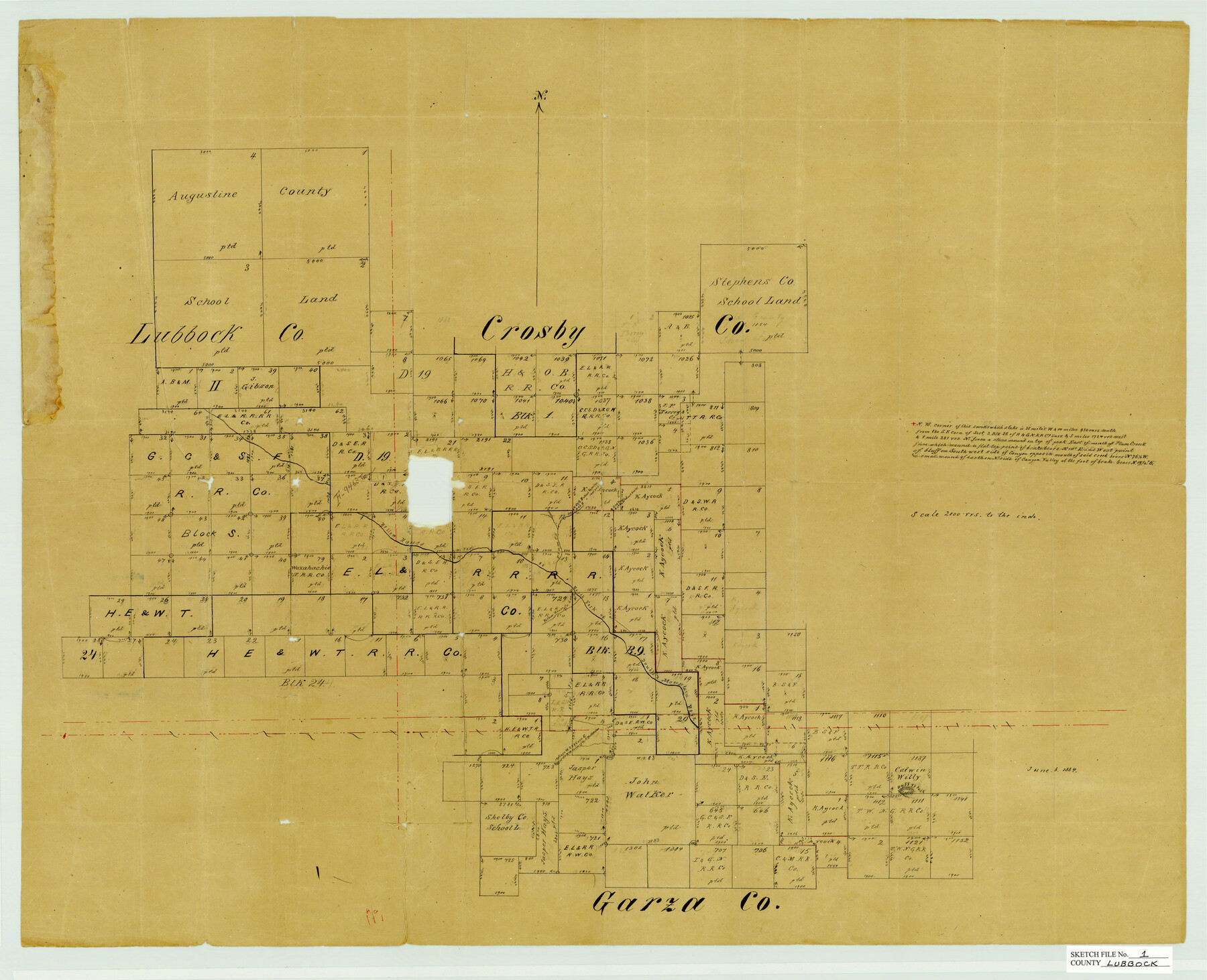
Lubbock County Sketch File 1
Large Sketch of Parts of Lubbock, Crosby & Garza Counties, Texas
-
Map/Doc
12015
-
Collection
General Map Collection
-
Object Dates
6/6/1884 (Creation Date)
-
Counties
Lubbock Crosby Garza
-
Subjects
Surveying Sketch File
-
Height x Width
22.5 x 27.6 inches
57.2 x 70.1 cm
-
Medium
paper, manuscript
-
Scale
1" = 2000 varas
-
Features
Plum Creek
Yellow House Creek
North Fork of Double Mountain Fork
Duffy Peak
Part of: General Map Collection
Flight Mission No. DIX-7P, Frame 14, Aransas County

Print $20.00
- Digital $50.00
Flight Mission No. DIX-7P, Frame 14, Aransas County
1956
Size 18.8 x 22.6 inches
Map/Doc 83866
Hartley County Working Sketch 3

Print $20.00
- Digital $50.00
Hartley County Working Sketch 3
1928
Size 24.6 x 24.0 inches
Map/Doc 66053
McMullen County Working Sketch 4

Print $20.00
- Digital $50.00
McMullen County Working Sketch 4
1922
Size 36.2 x 36.6 inches
Map/Doc 70705
Red River County Rolled Sketch 7A

Print $20.00
- Digital $50.00
Red River County Rolled Sketch 7A
Size 28.3 x 33.1 inches
Map/Doc 7472
Parker County Working Sketch 9

Print $20.00
- Digital $50.00
Parker County Working Sketch 9
1958
Map/Doc 71459
Controlled Mosaic by Jack Amman Photogrammetric Engineers, Inc - Sheet 32

Print $20.00
- Digital $50.00
Controlled Mosaic by Jack Amman Photogrammetric Engineers, Inc - Sheet 32
1954
Size 20.0 x 24.0 inches
Map/Doc 83485
Outer Continental Shelf Leasing Maps (Louisiana Offshore Operations)

Print $20.00
- Digital $50.00
Outer Continental Shelf Leasing Maps (Louisiana Offshore Operations)
1955
Size 14.0 x 12.8 inches
Map/Doc 76085
Rusk County Working Sketch 2

Print $40.00
- Digital $50.00
Rusk County Working Sketch 2
Size 36.4 x 58.2 inches
Map/Doc 63637
Val Verde County Rolled Sketch 77

Print $20.00
- Digital $50.00
Val Verde County Rolled Sketch 77
1981
Size 36.2 x 37.4 inches
Map/Doc 10087
Washington County

Print $40.00
- Digital $50.00
Washington County
1920
Size 33.4 x 48.6 inches
Map/Doc 63112
Loving County Sketch File 4

Print $40.00
- Digital $50.00
Loving County Sketch File 4
1961
Size 20.6 x 24.7 inches
Map/Doc 12014
Bandera County Working Sketch 13

Print $20.00
- Digital $50.00
Bandera County Working Sketch 13
1932
Size 29.1 x 25.3 inches
Map/Doc 67606
You may also like
[H. & T. C. , Block 47, Sections 26- 38]
![91255, [H. & T. C. , Block 47, Sections 26- 38], Twichell Survey Records](https://historictexasmaps.com/wmedia_w700/maps/91255-1.tif.jpg)
Print $2.00
- Digital $50.00
[H. & T. C. , Block 47, Sections 26- 38]
Size 14.5 x 9.2 inches
Map/Doc 91255
Sutton County Rolled Sketch F

Print $20.00
- Digital $50.00
Sutton County Rolled Sketch F
Size 12.7 x 38.9 inches
Map/Doc 7903
Grayson County Sketch File 18

Print $6.00
- Digital $50.00
Grayson County Sketch File 18
1859
Size 12.2 x 7.9 inches
Map/Doc 24487
Brewster Co[unty]
![16947, Brewster Co[unty], General Map Collection](https://historictexasmaps.com/wmedia_w700/maps/16947.tif.jpg)
Print $40.00
- Digital $50.00
Brewster Co[unty]
1904
Size 63.5 x 48.0 inches
Map/Doc 16947
Lampasas County Sketch File 5

Print $8.00
- Digital $50.00
Lampasas County Sketch File 5
1869
Size 12.8 x 7.9 inches
Map/Doc 29396
Galveston County Working Sketch 13

Print $20.00
- Digital $50.00
Galveston County Working Sketch 13
1975
Size 23.1 x 16.7 inches
Map/Doc 69350
Robertson County Sketch File 6

Print $4.00
Robertson County Sketch File 6
1870
Size 8.9 x 7.6 inches
Map/Doc 35362
Hidalgo County Sketch File 18

Print $4.00
- Digital $50.00
Hidalgo County Sketch File 18
Size 12.0 x 8.1 inches
Map/Doc 26446
University Lands Blocks 34 to 37, Terrell County, Isogonic Chart & Meridian Changes

Print $20.00
- Digital $50.00
University Lands Blocks 34 to 37, Terrell County, Isogonic Chart & Meridian Changes
Size 23.2 x 22.4 inches
Map/Doc 62940
United States Atlantic and Gulf Coasts Including Puerto Rico and the Virgin Islands

Print $40.00
- Digital $50.00
United States Atlantic and Gulf Coasts Including Puerto Rico and the Virgin Islands
1973
Size 21.9 x 60.6 inches
Map/Doc 76125
Andrews County Sketch File 8

Print $36.00
- Digital $50.00
Andrews County Sketch File 8
1943
Size 11.2 x 8.9 inches
Map/Doc 12831
Map of Coryell County

Print $20.00
- Digital $50.00
Map of Coryell County
1874
Size 22.4 x 26.8 inches
Map/Doc 3445