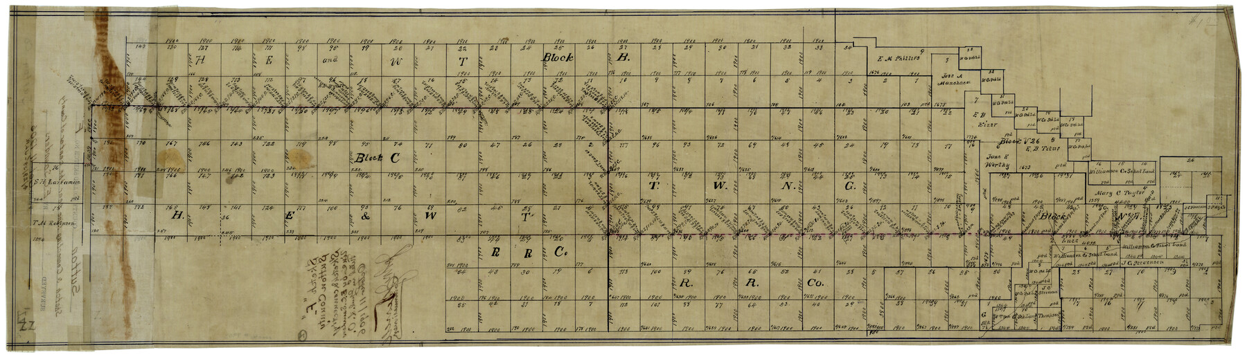
Sutton County Rolled Sketch F
[Sketch of part of H. E. & W. T. R.R. Co. Blocks B and C and area to the west]
-
Map/Doc
7903
-
Collection
General Map Collection
-
Object Dates
10/11/1906 (File Date)
-
People and Organizations
E.C. Saunders (Surveyor/Engineer)
-
Counties
Sutton
-
Subjects
Surveying Rolled Sketch
-
Height x Width
12.7 x 38.9 inches
32.3 x 98.8 cm
-
Medium
linen, manuscript
Part of: General Map Collection
Terrell County Rolled Sketch 58

Print $40.00
- Digital $50.00
Terrell County Rolled Sketch 58
1931
Size 49.1 x 41.8 inches
Map/Doc 9993
Kerr County Working Sketch 27

Print $20.00
- Digital $50.00
Kerr County Working Sketch 27
1970
Size 25.4 x 20.8 inches
Map/Doc 70058
Reeves County Working Sketch 52
Print $40.00
- Digital $50.00
Reeves County Working Sketch 52
1977
Size 60.3 x 41.9 inches
Map/Doc 63495
Jefferson County Rolled Sketch 67

Print $20.00
- Digital $50.00
Jefferson County Rolled Sketch 67
2007
Size 21.1 x 23.6 inches
Map/Doc 93426
Kleberg County Rolled Sketch 11

Print $20.00
- Digital $50.00
Kleberg County Rolled Sketch 11
1915
Size 21.0 x 26.5 inches
Map/Doc 6552
Map of Atascosa Co.

Print $40.00
- Digital $50.00
Map of Atascosa Co.
1894
Size 48.3 x 46.6 inches
Map/Doc 4877
Starr County Sketch File 20a

Print $12.00
- Digital $50.00
Starr County Sketch File 20a
1892
Size 14.3 x 8.8 inches
Map/Doc 36883
Map Showing Proposed System of State Highways

Print $5.00
- Digital $50.00
Map Showing Proposed System of State Highways
1917
Size 26.2 x 27.2 inches
Map/Doc 93717
Zavala County Sketch File A

Print $10.00
- Digital $50.00
Zavala County Sketch File A
1893
Size 8.7 x 7.9 inches
Map/Doc 41433
Brewster County Rolled Sketch 122

Print $20.00
- Digital $50.00
Brewster County Rolled Sketch 122
1974
Size 33.4 x 24.8 inches
Map/Doc 5296

Montgomery County Texas Historical Map

Montgomery County Texas Historical Map
Size 23.2 x 35.3 inches
Map/Doc 94404
You may also like
Carte Nouvelle de la Mer du Sud

Print $20.00
- Digital $50.00
Carte Nouvelle de la Mer du Sud
1730
Size 25.8 x 39.6 inches
Map/Doc 93824
Flight Mission No. BRA-16M, Frame 139, Jefferson County

Print $20.00
- Digital $50.00
Flight Mission No. BRA-16M, Frame 139, Jefferson County
1953
Size 18.6 x 22.2 inches
Map/Doc 85745
Van Zandt County Sketch File 2

Print $9.00
- Digital $50.00
Van Zandt County Sketch File 2
1852
Size 12.9 x 4.9 inches
Map/Doc 39359
Flight Mission No. BRA-8M, Frame 125, Jefferson County

Print $20.00
- Digital $50.00
Flight Mission No. BRA-8M, Frame 125, Jefferson County
1953
Size 15.9 x 15.7 inches
Map/Doc 85621
Culberson County Rolled Sketch X1

Print $20.00
- Digital $50.00
Culberson County Rolled Sketch X1
1896
Size 20.1 x 20.1 inches
Map/Doc 5684
Waller County Sketch File 2

Print $52.00
- Digital $50.00
Waller County Sketch File 2
Size 13.3 x 9.0 inches
Map/Doc 39570
Flight Mission No. BQR-9K, Frame 14, Brazoria County

Print $20.00
- Digital $50.00
Flight Mission No. BQR-9K, Frame 14, Brazoria County
1952
Size 18.7 x 22.3 inches
Map/Doc 84043
[Rusk, Sutton, Garza, and Atascosa County School Lands]
![91219, [Rusk, Sutton, Garza, and Atascosa County School Lands], Twichell Survey Records](https://historictexasmaps.com/wmedia_w700/maps/91219-1.tif.jpg)
Print $20.00
- Digital $50.00
[Rusk, Sutton, Garza, and Atascosa County School Lands]
1913
Size 18.8 x 14.5 inches
Map/Doc 91219
The Republic County of Goliad. December 29, 1845

Print $20.00
The Republic County of Goliad. December 29, 1845
2020
Size 17.5 x 21.7 inches
Map/Doc 96152
Flight Mission No. CRC-4R, Frame 96, Chambers County

Print $20.00
- Digital $50.00
Flight Mission No. CRC-4R, Frame 96, Chambers County
1956
Size 18.4 x 22.2 inches
Map/Doc 84893
Hamilton County Working Sketch 36

Print $40.00
- Digital $50.00
Hamilton County Working Sketch 36
2008
Size 36.9 x 57.3 inches
Map/Doc 88996
Sketch of Colorado Co. presented by Mr. Mason

Print $2.00
- Digital $50.00
Sketch of Colorado Co. presented by Mr. Mason
1845
Size 14.3 x 8.2 inches
Map/Doc 69736