Duval County Sketch File 49
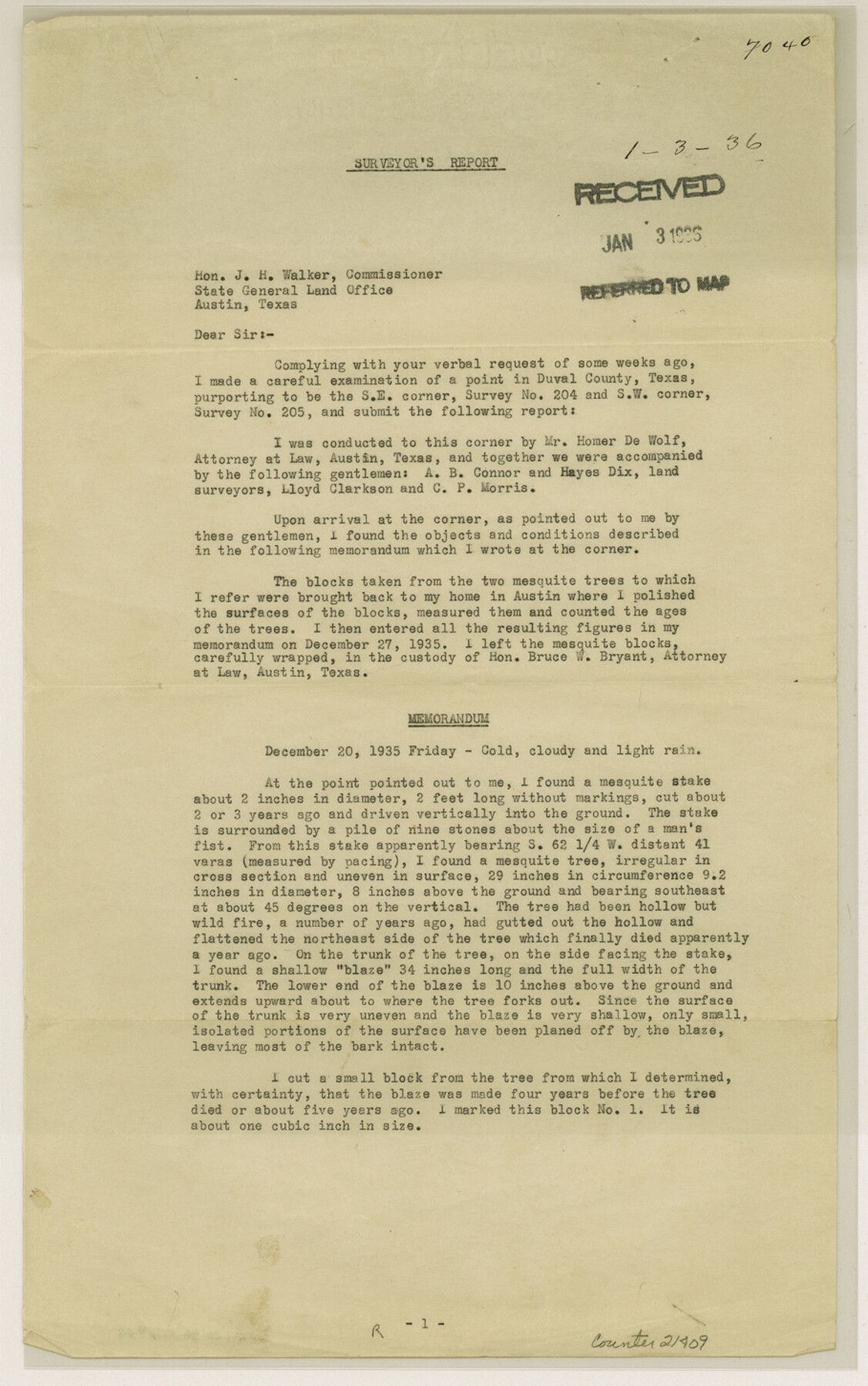
[Report on bearing tree at southeast corner of survey 204, J. Poitevent]
-
Map/Doc
21409
-
Collection
General Map Collection
-
Object Dates
1936/1/3 (File Date)
-
People and Organizations
Arthur A. Stiles (Surveyor/Engineer)
-
Counties
Duval
-
Subjects
Surveying Sketch File
-
Height x Width
14.5 x 9.1 inches
36.8 x 23.1 cm
-
Medium
paper, print
Part of: General Map Collection
Tyler County Rolled Sketch 12

Print $20.00
- Digital $50.00
Tyler County Rolled Sketch 12
1988
Size 25.2 x 19.3 inches
Map/Doc 8060
Brewster County Sketch File 37

Print $88.00
- Digital $50.00
Brewster County Sketch File 37
1967
Size 11.4 x 8.0 inches
Map/Doc 15903
Wichita County Working Sketch 13

Print $20.00
- Digital $50.00
Wichita County Working Sketch 13
1921
Size 16.5 x 32.8 inches
Map/Doc 72523
Cass County Rolled Sketch 6

Print $40.00
- Digital $50.00
Cass County Rolled Sketch 6
1957
Size 40.0 x 61.9 inches
Map/Doc 8586
El Paso County Rolled Sketch 47

Print $40.00
- Digital $50.00
El Paso County Rolled Sketch 47
1885
Size 41.3 x 90.4 inches
Map/Doc 8874
Flight Mission No. CLL-3N, Frame 5, Willacy County

Print $20.00
- Digital $50.00
Flight Mission No. CLL-3N, Frame 5, Willacy County
1954
Size 18.4 x 22.1 inches
Map/Doc 87071
Hutchinson County Sketch File 37

Print $10.00
- Digital $50.00
Hutchinson County Sketch File 37
Size 11.3 x 8.8 inches
Map/Doc 27275
Padre Island National Seashore

Print $4.00
- Digital $50.00
Padre Island National Seashore
Size 16.1 x 22.4 inches
Map/Doc 60541
Wilson County Sketch File 4

Print $28.00
- Digital $50.00
Wilson County Sketch File 4
1851
Size 8.4 x 7.7 inches
Map/Doc 40404
Smith County Rolled Sketch 6E1

Print $20.00
- Digital $50.00
Smith County Rolled Sketch 6E1
1966
Size 27.4 x 22.7 inches
Map/Doc 10612
San Patricio County Rolled Sketch 29

Print $20.00
- Digital $50.00
San Patricio County Rolled Sketch 29
Size 39.2 x 45.5 inches
Map/Doc 9893
Runnels County Working Sketch 31

Print $20.00
- Digital $50.00
Runnels County Working Sketch 31
1959
Size 28.3 x 31.3 inches
Map/Doc 63629
You may also like
The Republic County of Washington. Spring 1842

Print $20.00
The Republic County of Washington. Spring 1842
2020
Size 11.8 x 21.7 inches
Map/Doc 96308
Sutton County Sketch File 50

Print $20.00
- Digital $50.00
Sutton County Sketch File 50
1941
Size 18.6 x 18.4 inches
Map/Doc 12392
Guadalupe County Sketch File 22

Print $20.00
- Digital $50.00
Guadalupe County Sketch File 22
1957
Size 16.2 x 16.5 inches
Map/Doc 11591
Right of Way and Track Map, the Missouri, Kansas & Texas Ry. Of Texas operated by the Missouri, Kansas & Texas Ry. Of Texas, Houston Division

Print $40.00
- Digital $50.00
Right of Way and Track Map, the Missouri, Kansas & Texas Ry. Of Texas operated by the Missouri, Kansas & Texas Ry. Of Texas, Houston Division
1918
Size 26.0 x 62.1 inches
Map/Doc 64785
Baylor County

Print $40.00
- Digital $50.00
Baylor County
1917
Size 48.1 x 40.2 inches
Map/Doc 66714
Amistad International Reservoir on Rio Grande 83

Print $20.00
- Digital $50.00
Amistad International Reservoir on Rio Grande 83
1949
Size 28.5 x 40.3 inches
Map/Doc 75512
United States, 1956 Revised Edition

Print $20.00
- Digital $50.00
United States, 1956 Revised Edition
1946
Size 47.9 x 35.9 inches
Map/Doc 78630
Map of Lake Travis with detailed maps of Lakeway, Briarcliff, Lago Vista, Highland Lake Estates

Map of Lake Travis with detailed maps of Lakeway, Briarcliff, Lago Vista, Highland Lake Estates
Size 23.0 x 35.3 inches
Map/Doc 94374
Sutton County Working Sketch 10

Print $40.00
- Digital $50.00
Sutton County Working Sketch 10
1972
Size 71.0 x 42.9 inches
Map/Doc 62353
San Jacinto County Sketch File 18

Print $20.00
San Jacinto County Sketch File 18
1934
Size 43.6 x 18.1 inches
Map/Doc 10599
Nueces County Sketch File 11

Print $40.00
- Digital $50.00
Nueces County Sketch File 11
1859
Size 11.2 x 8.6 inches
Map/Doc 32518
Edwards County Sketch File 9

Print $20.00
- Digital $50.00
Edwards County Sketch File 9
Size 16.9 x 37.8 inches
Map/Doc 10443