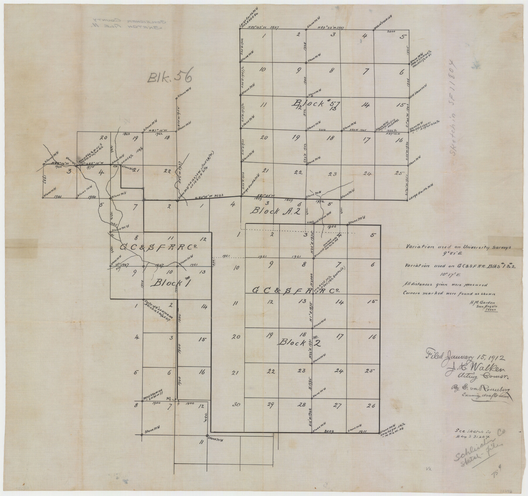
Schleicher County Sketch File 11
[Sketch showing University Land Block 57 and area to the south and west in Schleicher and Crockett Counties]
-
Map/Doc
12298
-
Collection
General Map Collection
-
Object Dates
1/12/1912 (Creation Date)
1/15/1912 (File Date)
-
People and Organizations
H.M. Garden (Surveyor/Engineer)
-
Counties
Schleicher Crockett
-
Subjects
Surveying Sketch File
-
Height x Width
21.5 x 30.5 inches
54.6 x 77.5 cm
-
Medium
paper, manuscript
Part of: General Map Collection
Coast Chart No. 106 - Oyster Bay to Matagorda Bay, Texas

Print $20.00
- Digital $50.00
Coast Chart No. 106 - Oyster Bay to Matagorda Bay, Texas
1878
Size 24.7 x 30.0 inches
Map/Doc 69928
Gonzales County Working Sketch 4b

Print $20.00
- Digital $50.00
Gonzales County Working Sketch 4b
1979
Size 21.2 x 27.3 inches
Map/Doc 63220
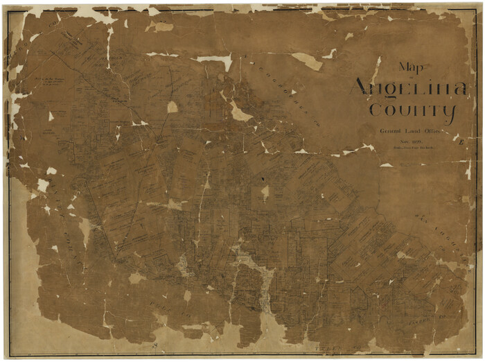
Map of Angelina County
Print $40.00
- Digital $50.00
Map of Angelina County
1899
Size 39.1 x 52.3 inches
Map/Doc 4777
United States - Gulf Coast - Galveston to Rio Grande

Print $20.00
- Digital $50.00
United States - Gulf Coast - Galveston to Rio Grande
1941
Size 26.7 x 18.5 inches
Map/Doc 72751
Palo Pinto County Sketch File 22

Print $20.00
- Digital $50.00
Palo Pinto County Sketch File 22
1939
Size 19.6 x 15.0 inches
Map/Doc 12134
Rusk County Working Sketch 28

Print $20.00
- Digital $50.00
Rusk County Working Sketch 28
1934
Size 24.2 x 18.3 inches
Map/Doc 63664
Flight Mission No. DCL-6C, Frame 180, Kenedy County

Print $20.00
- Digital $50.00
Flight Mission No. DCL-6C, Frame 180, Kenedy County
1943
Size 18.5 x 22.4 inches
Map/Doc 85992
Eastland County Rolled Sketch 25

Print $20.00
- Digital $50.00
Eastland County Rolled Sketch 25
1990
Size 36.9 x 47.7 inches
Map/Doc 8831

Jack County Sketch File 18c

Print $60.00
- Digital $50.00
Jack County Sketch File 18c
Size 20.0 x 30.7 inches
Map/Doc 11828
Flight Mission No. DCL-6C, Frame 79, Kenedy County

Print $20.00
- Digital $50.00
Flight Mission No. DCL-6C, Frame 79, Kenedy County
1943
Size 18.6 x 22.4 inches
Map/Doc 85921
Leon County Sketch File 3

Print $4.00
- Digital $50.00
Leon County Sketch File 3
Size 12.4 x 7.9 inches
Map/Doc 29713
You may also like
Navasota River, Grayson Crossing Sheet

Print $20.00
- Digital $50.00
Navasota River, Grayson Crossing Sheet
1937
Size 42.8 x 21.1 inches
Map/Doc 65071
Maps of Gulf Intracoastal Waterway, Texas - Sabine River to the Rio Grande and connecting waterways including ship channels

Print $20.00
- Digital $50.00
Maps of Gulf Intracoastal Waterway, Texas - Sabine River to the Rio Grande and connecting waterways including ship channels
1966
Size 14.5 x 22.2 inches
Map/Doc 61931
Medina County Rolled Sketch 8

Print $20.00
- Digital $50.00
Medina County Rolled Sketch 8
1975
Size 24.8 x 25.5 inches
Map/Doc 6742
Zapata County Working Sketch 25

Print $40.00
- Digital $50.00
Zapata County Working Sketch 25
2009
Size 36.9 x 71.8 inches
Map/Doc 89051
Harris County Historic Topographic 24

Print $20.00
- Digital $50.00
Harris County Historic Topographic 24
1916
Size 29.2 x 22.9 inches
Map/Doc 65835
Fisher County Working Sketch 15

Print $20.00
- Digital $50.00
Fisher County Working Sketch 15
1958
Size 22.2 x 22.6 inches
Map/Doc 69149
Concho County Sketch File 37

Print $20.00
- Digital $50.00
Concho County Sketch File 37
1938
Size 18.7 x 29.1 inches
Map/Doc 11162
[Townships 1 & 2, Blocks 53, 54 & 55]
![92952, [Townships 1 & 2, Blocks 53, 54 & 55], Twichell Survey Records](https://historictexasmaps.com/wmedia_w700/maps/92952-1.tif.jpg)
Print $20.00
- Digital $50.00
[Townships 1 & 2, Blocks 53, 54 & 55]
Size 34.3 x 20.0 inches
Map/Doc 92952
Fort Bend County Working Sketch 16

Print $20.00
- Digital $50.00
Fort Bend County Working Sketch 16
1953
Size 42.4 x 46.0 inches
Map/Doc 69222
Crane County Sketch File 20

Print $8.00
- Digital $50.00
Crane County Sketch File 20
1928
Size 11.0 x 8.5 inches
Map/Doc 19586
Wichita County Sketch File A

Print $4.00
- Digital $50.00
Wichita County Sketch File A
1861
Size 7.8 x 10.3 inches
Map/Doc 40036
Upton County Working Sketch 16

Print $20.00
- Digital $50.00
Upton County Working Sketch 16
1941
Size 17.1 x 12.0 inches
Map/Doc 69512