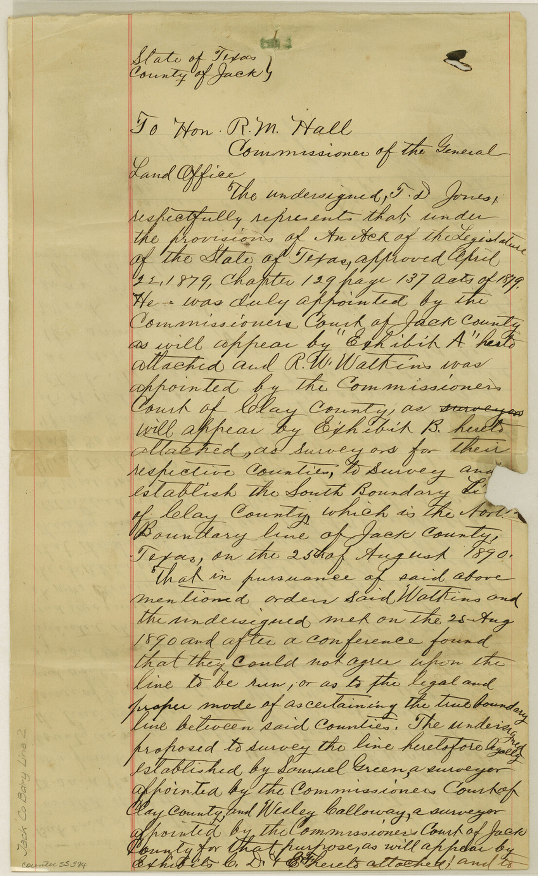
Jack County Boundary File 2
[Court Orders regarding Jack-Clay Boundary lines]
-
Map/Doc
55384
-
Collection
General Map Collection
-
Counties
Jack
-
Subjects
County Boundaries
-
Height x Width
14.3 x 8.8 inches
36.3 x 22.4 cm
Part of: General Map Collection
Harbor Pass and Bar at Brazos Santiago, Texas

Print $20.00
- Digital $50.00
Harbor Pass and Bar at Brazos Santiago, Texas
1879
Size 18.1 x 27.4 inches
Map/Doc 73002
Brewster County Rolled Sketch 125

Print $179.00
- Digital $50.00
Brewster County Rolled Sketch 125
1889
Map/Doc 43141
Kimble County

Print $40.00
- Digital $50.00
Kimble County
1930
Size 41.0 x 49.0 inches
Map/Doc 77340
Angelina County Working Sketch 1

Print $20.00
- Digital $50.00
Angelina County Working Sketch 1
Size 17.3 x 17.8 inches
Map/Doc 67081
Map of Washburn, Armstrong County, Texas junction of Pan-Handle (Southern Kansas) and Fort Worth & Denver City R'ys

Print $20.00
- Digital $50.00
Map of Washburn, Armstrong County, Texas junction of Pan-Handle (Southern Kansas) and Fort Worth & Denver City R'ys
1888
Map/Doc 97426
Parmer County

Print $20.00
- Digital $50.00
Parmer County
1926
Size 44.9 x 36.9 inches
Map/Doc 95610
Jefferson County Rolled Sketch 27

Print $20.00
- Digital $50.00
Jefferson County Rolled Sketch 27
1948
Size 24.2 x 46.6 inches
Map/Doc 9292
Concho County Working Sketch 8

Print $20.00
- Digital $50.00
Concho County Working Sketch 8
1948
Size 47.0 x 42.6 inches
Map/Doc 68190
Presidio County Rolled Sketch 53

Print $20.00
- Digital $50.00
Presidio County Rolled Sketch 53
1911
Size 23.9 x 18.2 inches
Map/Doc 7347
Flight Mission No. DQN-1K, Frame 135, Calhoun County

Print $20.00
- Digital $50.00
Flight Mission No. DQN-1K, Frame 135, Calhoun County
1953
Size 18.3 x 22.4 inches
Map/Doc 84198
Walker County Working Sketch 2

Print $20.00
- Digital $50.00
Walker County Working Sketch 2
1918
Size 16.7 x 14.5 inches
Map/Doc 72282
Concho County Sketch File 41

Print $6.00
- Digital $50.00
Concho County Sketch File 41
1948
Size 14.3 x 8.8 inches
Map/Doc 19197
You may also like
Map of Runnels County

Print $20.00
- Digital $50.00
Map of Runnels County
1867
Size 27.3 x 19.3 inches
Map/Doc 4003
Duval County Sketch File 53

Print $4.00
- Digital $50.00
Duval County Sketch File 53
1937
Size 11.6 x 7.3 inches
Map/Doc 21416
Zavala County Working Sketch 28

Print $20.00
- Digital $50.00
Zavala County Working Sketch 28
1994
Size 34.0 x 43.5 inches
Map/Doc 62103
Block 39 of the Brown Subdivision being a part of the Northeast Quarter Section 4, Block O

Print $20.00
- Digital $50.00
Block 39 of the Brown Subdivision being a part of the Northeast Quarter Section 4, Block O
1954
Size 14.8 x 14.2 inches
Map/Doc 92822
Goliad County Sketch File 22

Print $12.00
- Digital $50.00
Goliad County Sketch File 22
1855
Size 12.8 x 8.1 inches
Map/Doc 24289
Township 2 North Range 11 West, North Western District, Louisiana

Print $20.00
- Digital $50.00
Township 2 North Range 11 West, North Western District, Louisiana
1884
Size 19.7 x 24.7 inches
Map/Doc 65876
Flight Mission No. CRK-3P, Frame 132, Refugio County

Print $20.00
- Digital $50.00
Flight Mission No. CRK-3P, Frame 132, Refugio County
1956
Size 18.6 x 22.6 inches
Map/Doc 86920
Starr County Working Sketch 11

Print $20.00
- Digital $50.00
Starr County Working Sketch 11
1944
Size 18.1 x 17.7 inches
Map/Doc 63927
Foard County, Texas

Print $20.00
- Digital $50.00
Foard County, Texas
1891
Size 20.6 x 24.5 inches
Map/Doc 4338
General Highway Map. Detail of Cities and Towns in Jefferson County, Texas. City Map of Port Arthur and vicinity, Jefferson County, Texas

Print $20.00
General Highway Map. Detail of Cities and Towns in Jefferson County, Texas. City Map of Port Arthur and vicinity, Jefferson County, Texas
1961
Size 18.0 x 24.7 inches
Map/Doc 79540
Pecos County Sketch File 49c

Print $10.00
- Digital $50.00
Pecos County Sketch File 49c
Size 5.9 x 8.7 inches
Map/Doc 33768
Fort Bend County Boundary File 4

Print $40.00
- Digital $50.00
Fort Bend County Boundary File 4
Size 18.5 x 26.2 inches
Map/Doc 53567