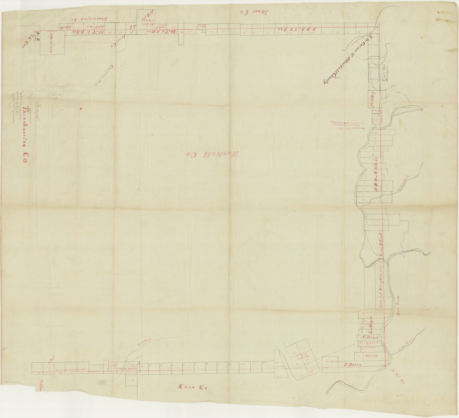
Haskell County Boundary File 1a
-
Map/Doc
54536
-
Collection
General Map Collection
-
Counties
Haskell
-
Subjects
County Boundaries
-
Height x Width
34.9 x 38.3 inches
88.6 x 97.3 cm
Part of: General Map Collection
Atascosa County Rolled Sketch 27

Print $20.00
- Digital $50.00
Atascosa County Rolled Sketch 27
2012
Size 25.9 x 34.1 inches
Map/Doc 95410
Young County Rolled Sketch 2

Print $20.00
- Digital $50.00
Young County Rolled Sketch 2
Size 26.2 x 25.0 inches
Map/Doc 8292
Polk County Sketch File 9

Print $28.00
- Digital $50.00
Polk County Sketch File 9
1861
Size 11.9 x 7.7 inches
Map/Doc 34136
[Sketch with field note calls of the boundaries of Webb, Duval, Jim Wells,Nueces, Kleberg, Zapata, Jim Hogg, Brooks, Willacy, Starr, Hidalgo and Cameron Counties]
![1689, [Sketch with field note calls of the boundaries of Webb, Duval, Jim Wells,Nueces, Kleberg, Zapata, Jim Hogg, Brooks, Willacy, Starr, Hidalgo and Cameron Counties], General Map Collection](https://historictexasmaps.com/wmedia_w700/pdf_converted_jpg/qi_pdf_thumbnail_720.jpg)
Print $20.00
- Digital $50.00
[Sketch with field note calls of the boundaries of Webb, Duval, Jim Wells,Nueces, Kleberg, Zapata, Jim Hogg, Brooks, Willacy, Starr, Hidalgo and Cameron Counties]
1915
Size 21.9 x 26.2 inches
Map/Doc 1689
San Augustine County Sketch File 12

Print $4.00
San Augustine County Sketch File 12
Size 12.2 x 7.9 inches
Map/Doc 35656
Winkler County

Print $20.00
- Digital $50.00
Winkler County
1932
Size 39.7 x 38.5 inches
Map/Doc 95678
Zavalla [sic] County
![16938, Zavalla [sic] County, General Map Collection](https://historictexasmaps.com/wmedia_w700/maps/16938-1.tif.jpg)
Print $20.00
- Digital $50.00
Zavalla [sic] County
1894
Size 42.3 x 44.6 inches
Map/Doc 16938
Matagorda County Working Sketch Graphic Index, Sheet 2 (Sketches 17 to Most Recent)

Print $40.00
- Digital $50.00
Matagorda County Working Sketch Graphic Index, Sheet 2 (Sketches 17 to Most Recent)
1920
Size 40.1 x 48.6 inches
Map/Doc 76634
United States - Gulf Coast - Galveston to Rio Grande

Print $20.00
- Digital $50.00
United States - Gulf Coast - Galveston to Rio Grande
1941
Size 27.0 x 18.2 inches
Map/Doc 72754
Oldham County Sketch File 3

Print $12.00
- Digital $50.00
Oldham County Sketch File 3
1883
Size 8.2 x 7.8 inches
Map/Doc 33228
Flight Mission No. BRA-8M, Frame 72, Jefferson County

Print $20.00
- Digital $50.00
Flight Mission No. BRA-8M, Frame 72, Jefferson County
1953
Size 18.6 x 22.2 inches
Map/Doc 85592
Reeves County Rolled Sketch 22

Print $20.00
- Digital $50.00
Reeves County Rolled Sketch 22
1960
Size 40.8 x 20.9 inches
Map/Doc 7490
You may also like
Castro County Sketch File 3a

Print $4.00
- Digital $50.00
Castro County Sketch File 3a
1888
Size 14.1 x 8.4 inches
Map/Doc 17460
Caldwell County Sketch File 3

Print $4.00
- Digital $50.00
Caldwell County Sketch File 3
1872
Size 12.7 x 8.1 inches
Map/Doc 35827
Lipscomb County Boundary File 14a

Print $4.00
- Digital $50.00
Lipscomb County Boundary File 14a
Size 11.3 x 8.7 inches
Map/Doc 56368
Motley County Sketch File 14 (N)

Print $8.00
- Digital $50.00
Motley County Sketch File 14 (N)
Size 13.6 x 8.7 inches
Map/Doc 32048
Coast Chart No. 212 - From Latitude 26° 33' to the Rio Grande Texas

Print $20.00
- Digital $50.00
Coast Chart No. 212 - From Latitude 26° 33' to the Rio Grande Texas
1886
Size 27.2 x 18.2 inches
Map/Doc 72830
Hays County Rolled Sketch 25

Print $20.00
- Digital $50.00
Hays County Rolled Sketch 25
1925
Size 17.5 x 40.0 inches
Map/Doc 6181
Brewster County Sketch File FN-32

Print $8.00
- Digital $50.00
Brewster County Sketch File FN-32
Size 11.1 x 8.7 inches
Map/Doc 15854
O'Neall Terrace, a Re-Subdivision of Blocks 37-38-39-40-43-44-45-46-110-112-113-114 and Parts of Blocks 111 and 115, McCrummens Second Addition to the City of Lubbock, Texas

Print $20.00
- Digital $50.00
O'Neall Terrace, a Re-Subdivision of Blocks 37-38-39-40-43-44-45-46-110-112-113-114 and Parts of Blocks 111 and 115, McCrummens Second Addition to the City of Lubbock, Texas
Size 22.6 x 27.5 inches
Map/Doc 92743
McMullen County Sketch File 7

Print $40.00
- Digital $50.00
McMullen County Sketch File 7
1859
Size 19.1 x 11.6 inches
Map/Doc 31347
Mitchell County

Print $20.00
- Digital $50.00
Mitchell County
1922
Size 42.6 x 38.3 inches
Map/Doc 2309
Williamson County Boundary File 1

Print $66.00
- Digital $50.00
Williamson County Boundary File 1
Size 8.4 x 6.0 inches
Map/Doc 59974
Zapata County Rolled Sketch 27

Print $40.00
- Digital $50.00
Zapata County Rolled Sketch 27
1988
Size 48.5 x 36.4 inches
Map/Doc 10173